
30.5
PDI
14.7 mi
DISTANCE
4,684 ft
GAINED
5.9 %
AVG. GRADE
FULL CLIMB STATS
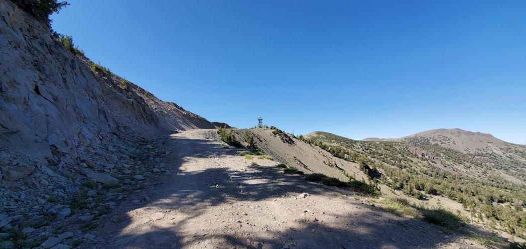
Page Contributor(s): Louis Ridgeway, Carson City, NV; Robert Barry, Reno, NV; Joey Galloway, Exeter, CA [featured image]
INTRO
Old Mt Rose Hwy - NF Dev Road 051 is a 14.7-mile, 4,684-foot climb in the Carson Range above Reno and Lake Tahoe, Nevada, rising from about 5,490 feet near Galena to just over 10,000 feet at a radio relay station a few hundred feet below Relay Peak (10,336') and Mt. Rose (10,785'), Washoe County's highest summit. We currently rank it the 45th-hardest climb in our database.
The character of the ride changes completely partway up.
The first roughly 10.5 miles follow Old Mt Rose Highway itself - the abandoned original alignment of NV-431 - a quiet, lightly-trafficked paved road since the modern highway was rerouted. The final stretch switches to NF Development Road 051, also known as Relay Peak Road, a rougher Forest Service dirt-and-gravel road that gains roughly 1,300 feet in under 4 miles, with loose rock increasing the higher you climb and a rough final switchback that most riders find easier on a mountain bike than a road-oriented gravel bike.
Relay Peak Road also marks the finish of a past local mountain bike race, The Bloody Rose, and it's a popular winter snowmobile and snowshoe route once the snow flies. Multiple PJAMM contributors have ridden the full route on gravel bikes and describe it as tough but rideable - "a great view from the relay station" is the consistent takeaway once you reach the top.
PLAN YOUR ROUTE
 We've partnered with Sherpa-Map.com to bring you the best route planning tool. With a PRO Membership you can use this climb as a reference when creating your route.
 The climb starts out as its steepest: the opening quarter-mile out of Galena kicks up to nearly 12%, and the first half-mile averages 11.4% - by far the hardest sustained pitch on the route. From there, Old Mt Rose Highway settles into a much more manageable rhythm, averaging under 8% through the middle miles as it winds through Carson Range forest.
The final miles on NF Development Road 051 (Relay Peak Road) ramp back up, averaging in the 6-7% range on loose dirt and rock, with several tight switchbacks near the top that are steeper and rougher than the numbers alone suggest. Overall the climb averages 5.9% over 14.7 miles and 4,684 feet of gain.
Roadway: Old Mt Rose Highway is paved and in decent shape for its first roughly 10.5 miles - it's the abandoned original alignment of NV-431, so it carries only local and recreational traffic rather than through-traffic. Around mile 10.5 the pavement ends and the route continues on NF Development Road 051 (Relay Peak Road), a Forest Service dirt-and-gravel road. The U.S. Forest Service's own travel map rates NFD 051 as a "dirt road suitable for passenger cars," but PJAMM contributors who've ridden it put the surface at roughly a 3 out of 5 for roughness, with loose rock that increases the higher you climb and a rough final switchback near the relay towers that's better suited to a mountain bike or wide-tire gravel setup than a standard gravel bike. Snow can linger on the upper road into early summer most years.
Traffic: Traffic on the paved lower section is light - it's a quiet, scenic Carson Range road well off the current Mt Rose Highway (NV-431). NF Development Road 051 sees even less: it's shared mainly with hikers and occasional Forest Service vehicles in summer, and with snowmobiles and snowshoers in winter, but almost no vehicle traffic once the pavement ends.
Parking: Roadside parking is available at the base of Old Mt Rose Highway in the Galena/Montreux area on the south edge of Reno. Riders can also start from the paved Mt Rose Summit trailhead lot on NV-431 and pick up Relay Peak Road (NFD 051) directly for a shorter, all-gravel version of the upper climb.
A road or gravel bike handles the paved lower 10.5 miles without issue, but the final gravel stretch up NF Development Road 051 rewards wider tires - 32-40mm gravel tires are comfortable for most of it, and riders who want to clean the rough final switchback below the relay towers without walking should consider a mountain bike instead.
Bring more water than you think you'll need: there are no water sources or services anywhere on the route once you leave Galena, and the climb gains nearly 4,700 feet into thin air above 9,000 feet, where sun and wind are both stronger than they feel at the bottom.
A spare tube or two and a pump or CO2 capable of handling a flat on loose gravel are worth carrying given how remote the upper section is. Dress in layers - temperatures at the 10,000-foot relay station can run 15-20°F cooler than in Reno, even in summer.
Before heading out on any cycling adventure check out our Things to Bring on a Cycling Trip and use our interactive check list to ensure you don't forget anything.
Reno-Tahoe International Airport is about 25 minutes from the base of the climb in Galena, making this an easy add-on to a Reno or Lake Tahoe cycling trip.
The route climbs into the Mount Rose Wilderness of the Humboldt-Toiyabe National Forest, and the payoff at the top is one of the best panoramic views in the Tahoe Basin - Lake Tahoe, Washoe Lake, and the Carson Range are all visible from near the relay towers on a clear day.
Because much of the route sits above 9,000 feet, plan a summer visit - snow can linger on the upper gravel into June, and afternoon thunderstorms are common in July and August, so an early start is worth it.
Riders looking for a bigger day in the same range can pair this with nearby Mt. Rose East, which climbs NV-431 itself up to Mt Rose Summit.
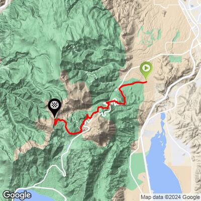
ROUTE MAP
MEMBER RATING
CURRENT WEATHER
PJAMM TRIPS ADVENTURE STARTER BUNDLES
Check out PJAMM Adventure's prepackaged (self-guided) cycling trips. They will help you plan, document and conquer your next adventure.
NEARBY CLIMBS (0) RADIAL PROXIMITY
FROM No Climbs Found
MEMBER REVIEWS & COMMENTS
Let us know what you thought of this climb. Signup for our FREE membership to write a review or post a comment.
Already have an account?
LOG IN HERE
