
24.2
PDI
8.4 mi
DISTANCE
3,413 ft
GAINED
7.7 %
AVG. GRADE
FULL CLIMB STATS
Page Contributor(s): Spencer Fawley, Scottsdale, AZ
INTRO
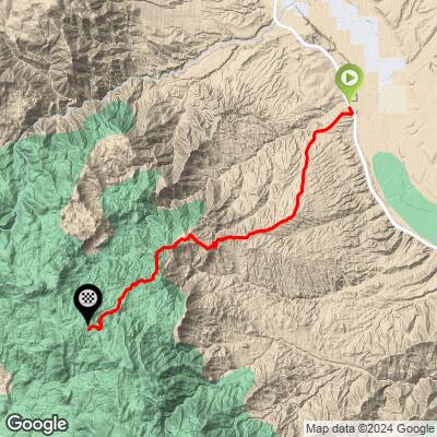
El Oso Road is an 8.4-mile gravel climb that leaves AZ-188 near Tonto Basin, Arizona, and climbs west into the Tonto National Forest toward the Four Peaks Wilderness, gaining 3,413 feet at an average grade of 7.7% - from a valley floor around 2,230 feet up to roughly 5,640 feet, where this climb's stats end and the road continues higher into rougher, high-clearance terrain toward Four Peaks itself.
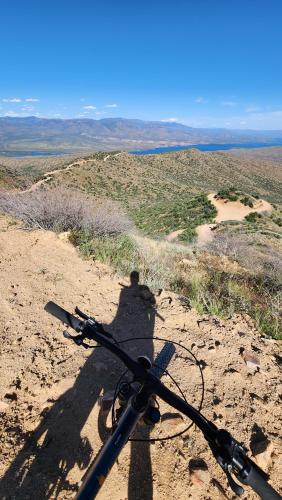
The road is graded dirt and gravel, generally smooth for a road this remote, but narrow in stretches along the mountainside with real exposure and drop-offs. It has become a popular gravel and bikepacking route out of the Phoenix area - showing up in Arizona Trail bike-route variations and Four Peaks bikepacking loops - because it delivers a long, honest dirt climb through saguaro and chaparral country with wide-open views back across Roosevelt Lake and the Mazatzal Mountains.
There is no shade and no water anywhere on the climb, and this is Sonoran Desert country inside a national forest that regularly runs at high fire danger - come prepared for heat and carry more water than you think you'll need. As one rider who has climbed it put it: "It's a pretty smooth dirt road the entire way. Pretty much uphill the whole way but going down was fun!"
PLAN YOUR ROUTE
 We've partnered with Sherpa-Map.com to bring you the best route planning tool. With a PRO Membership you can use this climb as a reference when creating your route.
 El Oso Road climbs a steady 7.7% average over its 8.4 miles, gaining 3,413 feet from about 2,230 feet at AZ-188 to roughly 5,640 feet at this climb's endpoint (the road itself keeps climbing beyond that, into rougher terrain, if you continue toward Four Peaks). Riders and hikers who have covered the road describe a consistent, unrelenting grade rather than a series of distinct pitches - there is no meaningful flat or descending section to recover on anywhere in the 8.4 miles.
If you want to preview exactly where the effort concentrates before you go, our Profile tool lets you scan the whole route pitch by pitch.
Roadway: El Oso Road is a maintained dirt-and-gravel Forest Service road (part of Forest Road 143, also known as Four Peaks Road) with a graded surface that's generally smooth for how remote it is, though it narrows in places along the mountainside with real exposure and drop-offs. A standard gravel or adventure bike handles the climb itself fine. The road gets progressively rougher and more technical above this climb's endpoint, where high-clearance 4x4 becomes necessary to continue toward Four Peaks.
Traffic: Light. This is a Forest Service road well off the state highway, used mainly by hikers and hunters headed into the Four Peaks Wilderness, occasional OHV riders, and ranchers - not commuter or through-traffic. Expect it quieter on weekdays and busier during hunting season and cooler-weather weekends.
Parking: There's room to pull off near where El Oso Road meets AZ-188 outside Tonto Basin. The Four Peaks OHV Staging Area, a few miles up Forest Road 143, is a maintained lot if you'd rather stage a little higher.
Bring a gravel or adventure bike with tires in the 40-45mm range - the surface is mostly smooth hardpack and gravel, but washboarding and loose sections show up seasonally, especially after summer monsoon rains cut ruts into the grade.
This is remote, shadeless Sonoran Desert terrain with no water sources anywhere on the climb, so carry more water than you would for a paved climb of the same length, plus real sun protection and the means to fix a flat well outside cell coverage. Check the Tonto National Forest's current fire-danger status before you go - this area regularly sits under seasonal fire restrictions that can affect camping and open flames nearby.
Before heading out on any cycling adventure check out our Things to Bring on a Cycling Trip and use our interactive check list to ensure you don't forget anything.
The nearest services are back down in Tonto Basin, where the Tonto Basin Marketplace on AZ-188 has gas, a small grocery and hardware store, and a deli - your last real stop for food and water before heading up into the forest. Lodging is thin in the immediate area; most riders base out of Payson, about 30 miles north, or camp at one of the Forest Service campgrounds near Theodore Roosevelt Lake.
Four Peaks Road continues well past this climb's endpoint into wilder, 4x4-only terrain, worth exploring further on foot or by bike if you have the legs and the daylight for it.
ROUTE MAP
MEMBER RATING
CURRENT WEATHER
PJAMM TRIPS ADVENTURE STARTER BUNDLES
Check out PJAMM Adventure's prepackaged (self-guided) cycling trips. They will help you plan, document and conquer your next adventure.
NEARBY CLIMBS (0) RADIAL PROXIMITY
FROM No Climbs Found
MEMBER REVIEWS & COMMENTS
Let us know what you thought of this climb. Signup for our FREE membership to write a review or post a comment.
Already have an account?
LOG IN HERE
