
26.9
PDI
35.5 mi
DISTANCE
6,028 ft
GAINED
2.9 %
AVG. GRADE
FULL CLIMB STATS
INTRO
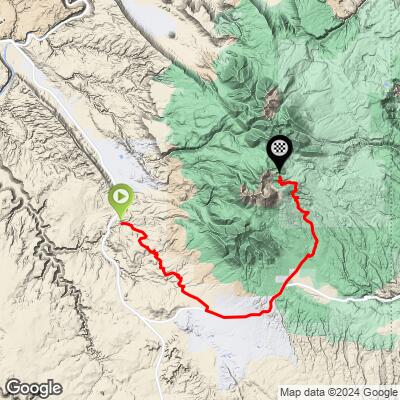
Dark Canyon is a long, remote gravel climb that leaves the paved outskirts of Moab, Utah and works its way into the La Sal Mountains - Utah's second-highest range - gaining just over 6,000 feet across 35.5 miles to a high point of 10,705 feet near Mount Peale, the range's tallest summit. The average grade is a modest 2.87%, but that hides a rolling profile: a paved climb up the La Sal Mountain Loop Road, a long gravel grind up and over 10,528-foot Geyser Pass, then a drop into Dark Canyon before one final push to the high point.
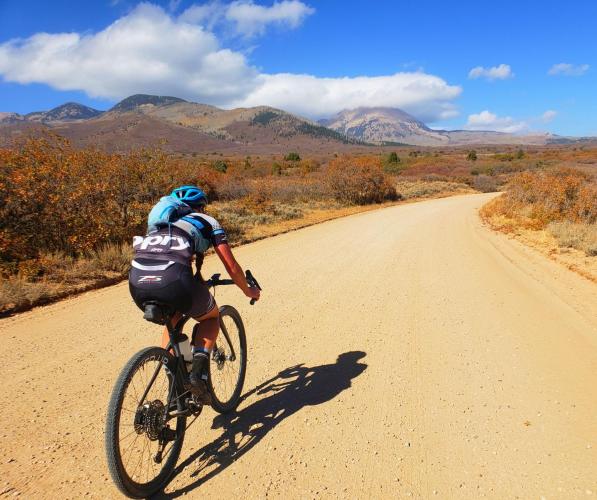
Dark Canyon itself is unmistakable - framed by the massive north-facing rock wall of Mount Peale (12,721 ft, the La Sals' highest summit), with the road threading a tight switchback beneath it before climbing toward the alpine basins below Mount Mellenthin and Mount Tukuhnikivatz. This is high-desert-meets-alpine terrain: red rock and sagebrush give way to aspen, spruce, and open meadows, with a newly repaved Loop Road down low and well-graded, unmaintained Forest Service gravel on the Geyser Pass side.
Topping out near 10,700 feet makes this a summer-only ride - snow closes the high country roughly November through May - and the remoteness past Geyser Pass means riders should be self-sufficient for the better part of a day.
PLAN YOUR ROUTE
 We've partnered with Sherpa-Map.com to bring you the best route planning tool. With a PRO Membership you can use this climb as a reference when creating your route.
 See more details and tools regarding this climb's grade via our interactive Profile Tool.
Roadway: The first roughly 18 miles, out to and over the La Sal Mountain Loop Road (FR 046), are paved - a multi-year Federal Highway Administration project widened, repaved, and improved drainage on this stretch, and by 2026 it's back in excellent condition (smooth enough that it's the centerpiece descent of the annual Gran Fondo Moab). At the signed Geyser Pass turnoff the pavement ends and Geyser Pass Road (FS 71) becomes well-graded Forest Service gravel - manageable on a standard gravel bike - the rest of the way over the pass and into Dark Canyon.
Traffic: Light. The paved Loop Road sees weekend scenic-drive and seasonal race traffic; the gravel beyond Geyser Pass is quiet, shared mainly with mountain bikers, hikers, and the occasional high-clearance vehicle headed for the Geyser Pass trailhead.
Parking: There's no dedicated trailhead for this specific climb - most riders start from town in Moab or a pullout along US-191/Old Airport Road at the base of the Loop Road. The Geyser Pass Trailhead, about 8 miles up Geyser Pass Road, has a parking area for staging partway up, though it has no potable water.
Once you leave Moab there's nothing - no water, food, or repair services anywhere on this climb, and the Geyser Pass Trailhead partway up has no potable water either, so carry everything you'll need for a full day out.
Standard gravel tires (35-40mm) are enough for the graded Geyser Pass Road surface, but pack layers - the route climbs from red-rock desert at roughly 5,300 feet to alpine terrain near 10,700 feet, and afternoon thunderstorms build quickly over the La Sals in summer.
Moab, at the base of the climb, has every bike shop, gear store, and grocery you'd need to stock up before you go.
Before heading out on any cycling adventure check out our Things to Bring on a Cycling Trip and use our interactive check list to ensure you don't forget anything.
This is a summer-only climb - the high country around Geyser Pass and Dark Canyon holds snow into late spring and gets it back by fall, so plan to ride roughly June through September.
The La Sal Mountain Loop Road finished a multi-year repaving and widening project heading into 2026, so the paved lower half is in the best shape it's been in years; the gravel beyond Geyser Pass remains unmaintained but well-graded.
Moab is one of the best-stocked cycling towns in the region - stage there for lodging, food, and bike shop support, and check current Manti-La Sal National Forest road conditions before heading up if you're riding early or late season.
ROUTE MAP
MEMBER RATING
CURRENT WEATHER
PJAMM TRIPS ADVENTURE STARTER BUNDLES
Check out PJAMM Adventure's prepackaged (self-guided) cycling trips. They will help you plan, document and conquer your next adventure.
NEARBY CLIMBS (0) RADIAL PROXIMITY
FROM No Climbs Found
MEMBER REVIEWS & COMMENTS
Let us know what you thought of this climb. Signup for our FREE membership to write a review or post a comment.
Already have an account?
LOG IN HERE
