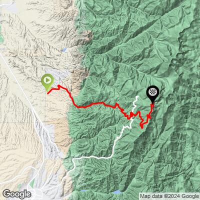
Tesuque Peak Bike Climb - PJAMM Cycling

36.6
PDI
17.2 mi
DISTANCE
5,163 ft
GAINED
5.7 %
AVG. GRADE

FULL CLIMB STATS

Page Contributor(s): Todd Anderson, Santa Fe, NM; Grant Soelhnel, Albuerque, NM; Elliot McKinney, Amarillo, TX; Reed Soehnel,

INTRO

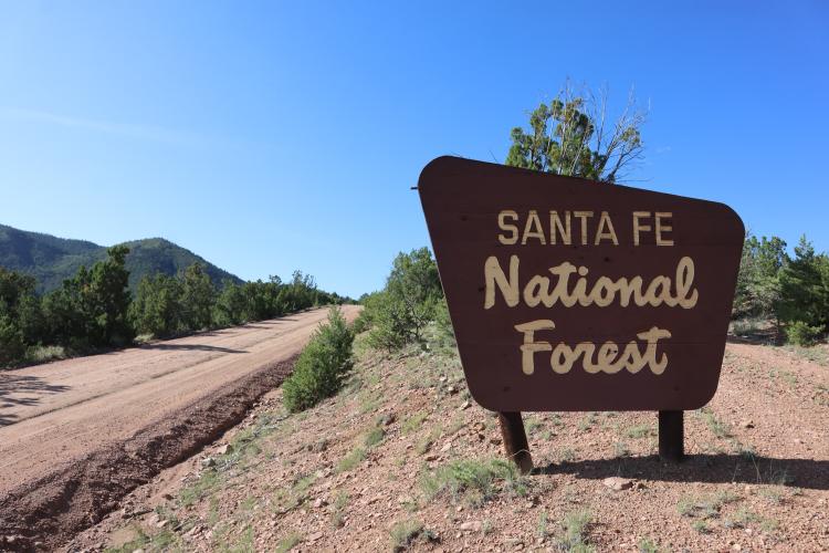
The Tesuque Peak climb is a challenging and scenic gravel route in the Sangre de Cristo Range, just north of Santa Fe, New Mexico and is the hardest gravel climb in New Mexico and ranked in the US Top 25. Spanning 17.2 miles and gaining 5,163 feet at an average grade of 5.7%, the climb begins on a paved road before transitioning to gravel as it enters the Santa Fe National Forest at mile 3.1. Cyclists will navigate through dense Aspen and Ponderosa pine forests, which obscure many potential views but provide a serene and shaded ride. The route features two gated sections and a brief stretch on a paved highway before the final ascent on a dirt road that begins very smooth and ends fairly rough. The climb tops out at the radio towers above Ski Santa Fe, at an elevation of 11,994 feet, offering excellent panoramic views of the Rio Grande Valley to the west and the Pecos Wilderness to the east.
Pro Members can see photos of road conditions on the interactive map in the profile section 

PLAN YOUR ROUTE

We've partnered with Sherpa-Map.com to bring you the best route planning tool. With a PRO Membership you can use this climb as a reference when creating your route.

See more details and tools regarding this climb's grade via our interactive Profile Tool.
Information Not Available

If you have any information regarding this climb, we'd like to hear from you. Click the CONTRIBUTE button to share your thoughts with us.

Information Not Available

If you have any information regarding this climb, we'd like to hear from you. Click the CONTRIBUTE button to share your thoughts with us.

Before heading out on any cycling adventure check out our Things to Bring on a Cycling Trip and use our interactive check list to ensure you don't forget anything.
Information Not Available

If you have any information regarding this climb, we'd like to hear from you. Click the CONTRIBUTE button to share your thoughts with us.

ROUTE MAP

MEMBER RATING

Not Yet Rated
-
Road
-
Traffic
-
Scenery

CURRENT WEATHER

PJAMM TRIPS ADVENTURE STARTER BUNDLES

Check out PJAMM Adventure's prepackaged (self-guided) cycling trips. They will help you plan, document and conquer your next adventure.
ALL TRIPS
Browse all of our prepackaged trips and find your next adventure!

NEARBY CLIMBS (0) RADIAL PROXIMITY

FROM
No Climbs Found

MEMBER REVIEWS & COMMENTS

Let us know what you thought of this climb. Signup for our FREE membership to write a review or post a comment.
Already have an account?
ROUTE MAP
PROFILE TOOL
Route Data
S.G. (%)
hide
Segment Data
hide
CLIMB SUMMARY

Cycling Teuque Peak - gravel route

Ride 17.2 miles gaining 5,163’ at 5.7% average grade to elevation 11,994’

This exceptional gravel bike climb is in the Sangre de Cristo Range in north central New Mexico, just north of Santa Fe.

Climb summary by PJAMM’s Brad Butterfield:

The climb begins just outside of Sante Fe on a paved road leading to the Sante Fe National Forest. The forest service road quickly turns to gravel as the climb pitches up. Summer monsoons soaked this road the day before PJAMM rode the climb and many sections of the road were still flooded. Unlike the Colorado gravel climbs which are defined by rocky roads and mountains, this climb in NM is memorable for the thick Aspen forests which line most of the climb. These forests block most of the views that would otherwise be available. There are a few very rough sections of the road, but nothing which a gravel bike can’t handle. About halfway up, there is a gated ‘Pueblo’. The 2 gates are not locked, but have signage asking to keep the gate closed. Bikes and vehicles are permitted through these gates. With a little over 6 miles to go, the road intersects with the main paved road up this mountain. You’ll ride the paved road for less than a mile, then cross one last gate (locked and prohibiting cars from continuing) to the summit. The final 6 miles of climbing are on a well maintained dirt road. I saw many hikers and runners on this portion of the road. A ski resort and radio/cell towers mark the summit of the climb.

Climb begins by riding northeast up NM 592

The first 1.5 miles of the climb are on a two lane state highway which felt safe to ride on.  This portion of the ride is comfortable, albeit brief.  After the two hairpins beginning at mile 1.1, stay straight at mile 1.6 onto the gravel and Hwy 76.  If you turn left, you will stay on NM 592 which is paved (on some maps, this is County Road 78).  The gravel begins at mile 1.5 by continuing straight, onto Hwy 76 - there is a road sign verifying you are on the correct route (see bottom left photo of collage above).

Start the gravel at mile 1.5

The road surface on this climb varies from smooth to fairly rough.

The photos above appear on the map at their location along the climb in the Profile Section. 

We enter Santa Fe National Forest at mile 3.1.

Santa Fe National Forest was established in 1915 during Woodrow Wilson’s presidency.  The forest is made up of 1.6 million acres, and is home to the Valles Caldera, a dormant volcano with a 15-mile wide crater.  

We encounter our first of two gates at mile 6.9

We ride by and through stands of ponderosa pine and aspen trees.

Ride on paved highway 457 from mile 10.6 to 11.3

We exit the brief paved segment at Aspen Vista picnic ground.

Our second and final gate on the climb is just after exiting the second stretch of pavement.


Many of the views are blocked by forest as we climb.

Stands of aspen trees can be seen along the climb.

You are 7/10’s of a mile from the finish when you see this sign on your right.

Pass Ski Santa Fe resort just before the finish of the climb.

We finish at a set of radio towers 2/10’s of a mile past the top of Tesuque Peak ski lift.

The climb tops out at elevation 11,994’ with 35% less oxygen than at sea level. At this location, there are panoramic views to the west of the Rio Grande Valley and Pecos Wilderness to the east.

That’s a wrap!!