![Cycling Mt. Mansfield, Vermont Cycling Mt. Mansfield, Vermont - looking down hillside toward town, hills covered in bright fall foliage]()
Cycling Mt. Mansfield (one day per year)
Ride 4.2 miles gaining 2,511’ at 11.5% average grade.
Mt. Mansfield is the highest point in Vermont (4,395’) and is located in the Green Mountains subrange of the Appalachian Mountains. The road is fully within Mount Mansfield State Forest (44,444 acres, established 2002).
This is an unbelievably scenic and challenging climb. The two drawbacks to cycling Mt. Mansfield are (a) it is open only one day per year for an annual bike race to the top -- otherwise, no bikes allowed, and (b) it is gravel. The gravel is the lesser of the two drawbacks -- at least you can ride on it!
![]()
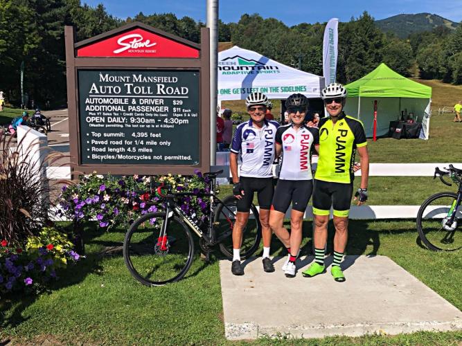
Bruce Pauly, Stacy Topping and Bruce Hamilton chalking up another PJAMM Top 100
As of August 30, 2022, Bruce 97 Top 100’s; Team Stacy and Bruce are at 86.
Climb summary by PJAMM good friend and contributor Bruce Hamilton.
This climb is located in a beautiful area of Northwest Vermont just north of Stowe at the base of Stowe Mountain Resort. It winds up to the top of Mt Mansfield – highest point in Vermont and it’s a private toll road that is open to cars in summer but open for bikes only one day each year. This is usually on the fourth Sunday in August and in order to ride this road you must enter the Race to the top of Vermont event held each year.
![Cycling Mt. Mansfield, Vermont Cycling Mt. Mansfield, Vermont - photo collage, toll road, PJAMM Cycling logo in corner]()
Climb’s Start.
The first ¼ mile of this road is paved and this results in the unusual situation of not being able to see the condition of the dirt from the beginning of the road. The event website states that gravel tires are required – it even says that they will turn back any entrants trying to ride on road tires. However, we showed up with only 30mm road tires and nobody pulled us out to say we could not ride. If we’d been able to see the dirt section before the day of the event, we would definitely not have tried this on road tires. Shady spots were slick from moisture and some sections exposed to sun were slippery from lack of grip on the dusty surface. If we’d been riding in either wetter or drier conditions we would not have been able to complete the ride. Wide tires are not really needed, but knobbies definitely are recommended. There is no shuttle down so you have to ride your bike down the hill as well - knobbies and disc brakes would definitely be desirable.
![Cycling Mt. Mansfield, Vermont Cycling Mt. Mansfield, Vermont - photo collage, fall foliage, ski signs, PJAMM Cycling logo in corner]()
The road is through Stowe Mountain Resort, Vermont.
This is a small event compared to Mt Washington (also a private road open only one day each year) and this event is usually conducted the weekend after the Mt Washington race. We did both of these as bookends of a New England trip. This is also not as difficult or as long as Mt Washington – there are several places along the way where the grade relaxes and there is an opportunity for recovery. It’s made more difficult by the rough surface, however, and would be very difficult in bad weather. An unusual PJAMM climb (dirt road and private road) but a fun event and a very pretty climb.
![Cycling Mt. Mansfield, Vermont Cycling Mt. Mansfield, Vermont - visitor center and informational signs at ride's end]()
End of the road.
FALL COLORS
![Cycling Mt. Mansfield, Vermont Cycling Mt. Mansfield, Vermont - photo collage, fall foliage, one-lane gravel road, PJAMM Cycling logo in corner]()
![Cycling Mt. Mansfield, Vermont Cycling Mt. Mansfield, Vermont - photo collage, fall foliage, one-lane gravel road, PJAMM Cycling logo in corner]()
![]() RACE TO THE TOP OF VERMONT
RACE TO THE TOP OF VERMONT ![]()
![]()
The annual cycling ride on Mount Mansfield, Race to the Top of Vermont (RTTTOVT) is held annually on the fourth Sunday in August.
![]()
Bruce, Stacy and Bruce at the finish -
Race to the Top of VErmont 2022

 We've partnered with Sherpa-Map.com to bring you the best route planning tool. With a PRO Membership you can use this climb as a reference when creating your route.

