
46.6
PDI
6.5 mi
DISTANCE
4,426 ft
GAINED
13.1 %
AVG. GRADE
FULL CLIMB STATS
Page Contributor(s): Ties Arts, Netherlands; Alex Yale, USA
INTRO
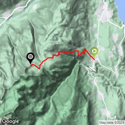
The climb to Rifugio Peller starts near Tuenno in Val di Non, Trentino-Alto Adige, and climbs 6.5 miles (10.4 km) to the mountain hut at 6,511 feet (1,984 m), gaining 4,426 feet (1,349 m) at a brutal 13.1% average grade. Currently ranked #56 in the world by PDI, this is one of the steepest sustained climbs anywhere - not a short, sharp wall, but 10-plus kilometers that essentially never lets up.
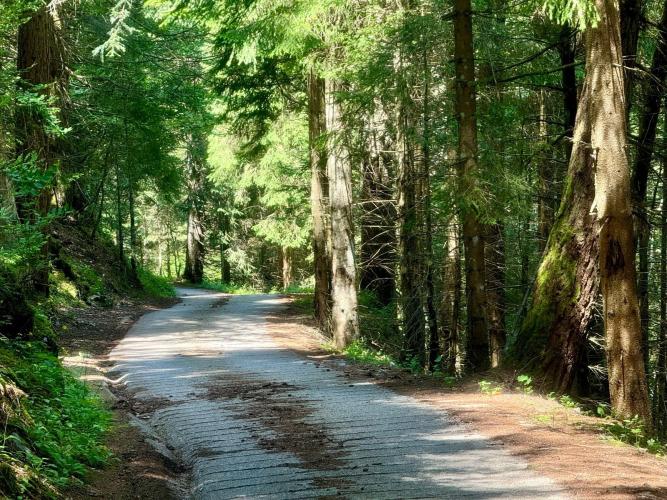
The road climbs out of the orchards around Tuenno into forest, alternating between well-maintained asphalt and steep, corrugated concrete ramps that keep traction manageable on the steepest pitches.
The final stretch to the rifugio turns to gravel - a few hundred meters of loose, very steep surface right at the finish, after your legs have already taken more than an hour of relentless climbing.
Rifugio Peller sits at the edge of the Adamello Brenta Nature Park, home to the Italian Alps' main population of reintroduced brown bears, in the shadow of the Brenta Dolomites. The reward for the effort is a hut with a drink, a snack, and sweeping views over Val di Non and Val di Sole - one of the more satisfying finish lines in Italian cycling for having earned every meter of it.
PLAN YOUR ROUTE
 We've partnered with Sherpa-Map.com to bring you the best route planning tool. With a PRO Membership you can use this climb as a reference when creating your route.
 There's no easy section on this climb - the grade holds in double digits for nearly the entire 10.4 km, occasionally relaxing into single digits before ramping back up on the corrugated-concrete pitches. At 13.1% average over 6.5 miles, this is sustained, not spiky: expect your legs to be under load essentially the whole way, with the final few hundred meters of loose gravel to the rifugio adding one more sting after everything that came before.
Roadway: The surface alternates between well-maintained asphalt and steep, corrugated concrete sections - the concrete shows up specifically on the steepest ramps, where it helps with traction on a grade that would be treacherous on smooth pavement. The final few hundred meters to Rifugio Peller itself are loose gravel, so expect a change in footing right at the finish, after your legs are already spent.
Traffic: This is a quiet mountain road with light traffic - it serves the rifugio and local forestry/agricultural access rather than through-traffic, so expect a peaceful, largely car-free climb.
Parking: There's no dedicated parking area right at the finish - the road effectively ends at the rifugio. Park in Tuenno at the base and ride the entire route; there's no practical way to shorten this climb from a lower starting point.
Bring your lowest gearing - a 13.1% average over 10.4 km means there's no coasting or recovery, and a compact crankset paired with a wide-range cassette (or a 1x setup with a very low bottom gear) will make the difference between surviving this climb and suffering through it on the wrong bike.
The final gravel stretch to the rifugio rewards a bit of tire volume and tread - if you're on narrow slicks, be ready to walk the last steep section rather than risk losing traction.
There are no services along the climb itself; the rifugio at the top has drinks and snacks, but carry your own water and food for the ascent, since this is a long, hard effort with nothing in between.
Before heading out on any cycling adventure check out our Things to Bring on a Cycling Trip and use our interactive check list to ensure you don't forget anything.
Tuenno, in Val di Non, is the obvious base for this climb - a small orchard-country town known for its apples, with basic services and easy access to the climb's start.
This is deep in the Adamello Brenta Nature Park, one of the last strongholds of the Alpine brown bear in Italy - a reminder that this is genuine wilderness, not a groomed tourist road. Give any wildlife you encounter plenty of space.
Ride this one on a clear day - the payoff at Rifugio Peller is the view over Val di Non, Val di Sole, and the Brenta Dolomites, and that's lost entirely in cloud or fog. Given the exposed, high-altitude finish, check current weather before committing, and be prepared for temperatures well below what you'll feel starting out in Tuenno's orchards.
ROUTE MAP
MEMBER RATING
CURRENT WEATHER
PJAMM TRIPS ADVENTURE STARTER BUNDLES
Check out PJAMM Adventure's prepackaged (self-guided) cycling trips. They will help you plan, document and conquer your next adventure.
NEARBY CLIMBS (0) RADIAL PROXIMITY
FROM No Climbs Found
MEMBER REVIEWS & COMMENTS
Let us know what you thought of this climb. Signup for our FREE membership to write a review or post a comment.
Already have an account?
LOG IN HERE
ayale

This is a very steep and peaceful route. You could do it on a road bike but it is nice to have easier climbing gears. The surface alternates between very well-maintained pavement and corrugated concrete for the steeper sections. At the top, there is a few hundred meters of very steep gravel to get to Rifugio Peller, where you can have a drink, a snack, and some nice views.
JohnJohnson
Thank you Alex for finding this World Top 100 for us 👍
