
29.8
PDI
12.9 mi
DISTANCE
4,466 ft
GAINED
6 %
AVG. GRADE
FULL CLIMB STATS
Page Contributor(s): Dave R, Hurricane UT; Nathan Leroy,
INTRO
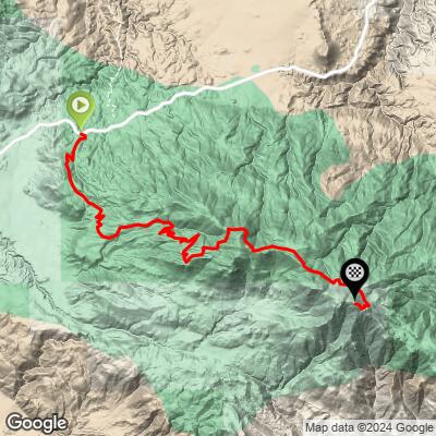
Toro Peak climbs 12.92 miles and gains 4,466 feet at an average grade of 6.04% up Santa Rosa Road (Forest Service road 7S02), a dirt-and-gravel road in the Santa Rosa Mountains above Mountain Center, California. It currently ranks #53 in PJAMM's world database. Toro Peak itself, at roughly 8,700 feet, is the highest point in the Santa Rosa range, about 22 miles south of Palm Springs.
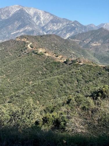
The climb is a steady, moderate dirt-road grind for its first ten miles - good gravel-bike surface, with wide views out over the Coachella Valley - before kicking up hard in the final half-mile, where the grade turns too steep and loose for most riders to stay on the bike all the way to the top. That last stretch also runs into a locked gate: the true, antenna-topped summit of Toro Peak sits on Santa Rosa Band of Cahuilla Indians reservation land, and public access beyond the gate has been inconsistent for years - sometimes open, more often closed. Treat the gate, with its sweeping desert views, as the realistic finish rather than counting on reaching the actual summit.
The road sits within the Santa Rosa and San Jacinto Mountains National Monument and is typically closed by snow and ice in winter, so it's best ridden in the cooler months outside of summer's high-desert heat.
PLAN YOUR ROUTE
 We've partnered with Sherpa-Map.com to bring you the best route planning tool. With a PRO Membership you can use this climb as a reference when creating your route.
 Toro Peak's 6.04% average hides a heavily back-loaded profile. The first ten miles are a steady grind, well under the overall average, before the final stretch spikes hard: the steepest half-mile on the route averages 17.03%, the steepest quarter-mile 18.12%, and the steepest full mile still averages 12.88%. Even measured over the steepest 5 miles the average is just 7.08%, which shows how concentrated the real difficulty is in that last pitch below the gate.
Roadway: Santa Rosa Road (Forest Road 7S02) is unpaved for essentially its entire length - a dirt-and-gravel Forest Service road that's in decent shape for a gravel bike for most of its distance, though washboarding and loose rock increase higher up. The final half-mile below the summit gate turns steep and loose enough that most riders end up walking. The road is typically closed by snow and ice in winter and can also close for fire risk or after storms, so check current Forest Service status before heading out.
Traffic: Traffic is light and almost entirely recreational - OHV riders, 4x4 traffic headed for the Yellow Post campsites, and the occasional hiker. There's no paved-road traffic to worry about once you leave Highway 74.
Parking: Park off Highway 74 near Mountain Center, where a pullout marks the start of the dirt climb up Santa Rosa Road. There's no other formal trailhead along the route.
A gravel bike with wider tires (40mm or up) handles the first ten miles comfortably; plan to walk, or ride a mountain bike, for the final steep, loose half-mile below the gate. Bring your lowest gearing regardless of bike choice for that last pitch.
There's no water, food or services anywhere on the mountain - carry everything you need from Mountain Center or Idyllwild, the nearest towns with services. Cell coverage is unreliable to nonexistent for much of the climb, so let someone know your plans before heading up.
Before heading out, check our Things to Bring on a Cycling Trip checklist to make sure you haven't forgotten anything.
Before heading out on any cycling adventure check out our Things to Bring on a Cycling Trip and use our interactive check list to ensure you don't forget anything.
Santa Rosa Road rides best outside of summer, when high-desert heat on the lower slopes and afternoon thunderstorm risk both increase; it's typically closed by snow and ice in winter, so spring and fall are the most reliable windows. Check current conditions with the San Bernardino National Forest's Santa Rosa Road recreation page or the Idyllwild Ranger District before heading out, since the road can also close for fire restrictions.
The road runs through the Santa Rosa and San Jacinto Mountains National Monument, and the Yellow Post campsites along the way make a reasonable base if you'd rather camp near the start than drive up from the desert floor same-day.
Keep in mind that Toro Peak's true summit sits behind a gate on Santa Rosa Band of Cahuilla Indians reservation land - treat the gate as the practical finish of this climb rather than counting on reaching the actual high point.
ROUTE MAP
MEMBER RATING
CURRENT WEATHER
PJAMM TRIPS ADVENTURE STARTER BUNDLES
Check out PJAMM Adventure's prepackaged (self-guided) cycling trips. They will help you plan, document and conquer your next adventure.
NEARBY CLIMBS (0) RADIAL PROXIMITY
FROM No Climbs Found
MEMBER REVIEWS & COMMENTS
Let us know what you thought of this climb. Signup for our FREE membership to write a review or post a comment.
Already have an account?
LOG IN HERE
