
26.9
PDI
6.4 mi
DISTANCE
2,725 ft
GAINED
8.1 %
AVG. GRADE
FULL CLIMB STATS
Page Contributor(s): Jon DeLacey, Durango, CO; Khalid Abdeleziz, Chandler, AZ; Aaron Lee, Buena Vista, CO
INTRO
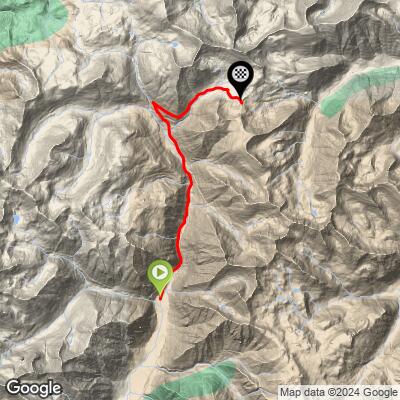
Cinnamon Pass tops out at roughly 12,600 feet in Colorado's San Juan Mountains, one of two high passes (with neighboring Engineer Pass) on the famous Alpine Loop between Silverton and Lake City. This southern approach climbs 2,725 feet over 6.4 miles from the upper Animas River valley near the Animas Forks ghost town. First opened as a wagon road in 1877 linking Lake City's mining camps to the Animas Valley, the route still passes the ruins of the boom that built it.
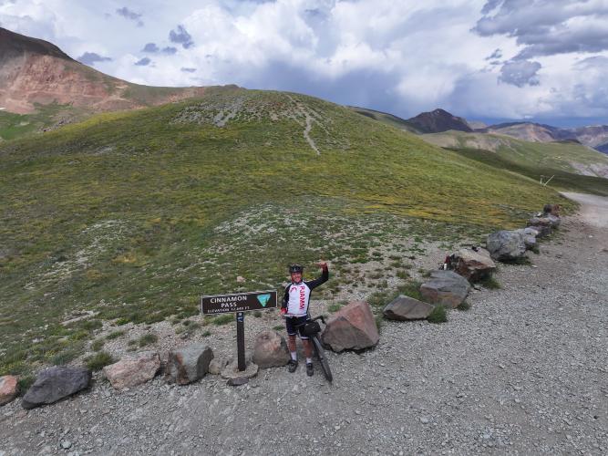
Whether it's genuinely rideable on a gravel bike is a running debate among PJAMM contributors who've done it:
Jon Delacey - Likely a little easier than Engineer Pass, not as rocky, but still very steep at this altitude. I ran 32x52 gearing and needed it - doable on a gravel bike with the right gearing and 40mm+ tires, though it's easier on a mountain bike.
Khalid Abdelaziz - Rideable on a gravel bike, but expect to walk a few spots. I'd definitely prefer a hardtail.
Aaron Lee - I did this on my gravel bike, so it's definitely rideable. Expect rocky, chunky sections where you're picking your line, plus heavy UTV, Jeep, and motorcycle traffic and a lot of dust. Beautiful route overall.
Artec - I would not ride Cinnamon Pass or any part of the Alpine Loop on a gravel bike.
PLAN YOUR ROUTE
 We've partnered with Sherpa-Map.com to bring you the best route planning tool. With a PRO Membership you can use this climb as a reference when creating your route.
 The average grade for the climb is 8.11%, but that number undersells how this one feels at altitude. The steepest point is a short ~100-yard pitch near 14.7%, and steep grinding continues in bursts - the toughest quarter-mile stretch still averages 14.5%, and even the toughest full mile holds just over 12%. It eases somewhat over the back half, with the steepest 5-mile window down around 8.8%, close to the overall course average.
Above 11,000 feet the thinner air makes even moderate pitches feel harder than the raw percentage suggests, and much of this climb sits well above that line - the final push to the 12,586' summit tops out among the highest gravel climbs in the U.S.
Roadway: This is an unpaved county road (San Juan County Road 2, becoming County Road 30 near the summit) - hard-packed dirt and gravel lower down, turning rockier and rutted with loose rock and washboard sections as you approach 12,000 feet. A gravel bike with wide tires (40mm or larger) and low gearing can get you up it, but expect a few short pitches where walking is the sane option, especially if it's been raining. The road is graded periodically by the county, but conditions can change year to year after spring runoff and summer monsoon storms.
Traffic: This is one of the most popular 4x4 routes in Colorado, and it shows - expect a steady stream of Jeeps, UTVs, and dirt bikes, especially on summer weekends, kicking up dust and sharing a narrow roadbed with you. Weekday mornings are noticeably quieter. The road is only open, snow permitting, from around late May/June through October; it's closed and impassable the rest of the year.
Parking: There's no formal trailhead. Most riders start from a pullout along CR 2 near the Animas Forks ghost town site, or drive further up as road conditions allow and park at one of the informal pullouts closer to the base of the steep section. A parking area also exists right at the pass summit for anyone shuttling or finishing a full Alpine Loop crossing.
Come dressed for the terrain, not just the distance. A gravel bike with 40mm+ tires and mountain-bike-low gearing (contributors report needing something like a 32x52 to keep spinning on the steepest pitches) is the minimum setup - anything narrower or more road-oriented will struggle on the loose, rocky sections near the top.
There is no water, food, or services anywhere on the route, so carry everything you need for several hours above treeline. Pack layers regardless of the forecast - afternoon thunderstorms build fast in the San Juans in summer, and temperatures at 12,600 feet can be 20-30 degrees colder than in Silverton. Sun protection matters more than usual at this altitude, and if you're not acclimated, budget extra time - the thin air makes even moderate pitches feel harder than the numbers suggest.
Before heading out on any cycling adventure check out our Things to Bring on a Cycling Trip and use our interactive check list to ensure you don't forget anything.
Silverton is the obvious base - a real (if small) mountain town with lodging, restaurants, and a bike shop, about 12 miles from the start of the climb via the old mining towns of Howardsville and Eureka. Lake City, on the far side of the pass, is the other classic base if you're riding the Alpine Loop as a point-to-point or full loop with Engineer Pass.
Plan around the season - Cinnamon Pass is normally only open, snow permitting, from late May or June into October, and conditions can change quickly after storms, so check current status before you commit to the drive. Cell service is unreliable to nonexistent for most of the route, so let someone know your plan and carry a map or GPX file as backup.
Because the summit sits above 12,500 feet, weather can turn fast even on a clear morning - check current summit conditions before you go with our free Weather tool.
ROUTE MAP
MEMBER RATING
CURRENT WEATHER
PJAMM TRIPS ADVENTURE STARTER BUNDLES
Check out PJAMM Adventure's prepackaged (self-guided) cycling trips. They will help you plan, document and conquer your next adventure.
NEARBY CLIMBS (0) RADIAL PROXIMITY
FROM No Climbs Found
MEMBER REVIEWS & COMMENTS
Let us know what you thought of this climb. Signup for our FREE membership to write a review or post a comment.
Already have an account?
LOG IN HERE
