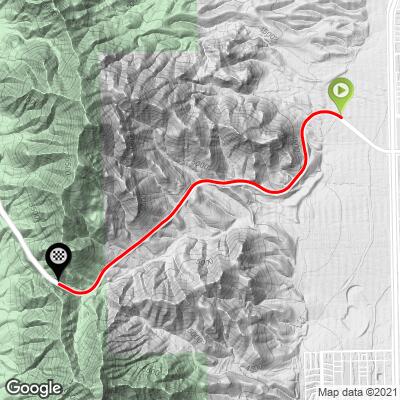
Smugglers Pass / Transmountain
West: 5.6 miles gaining 1,370’ at 4.6%
East: 4.4 miles gaining 1,600’ at 4.6%
This heavily travelled roadway passes over the just north of El Paso travels through and over the Franklin Mountains. The Franklin Mountains and this climb are entirely within the Franklin Mountains State Park which is itself located entirely within the city limits of El Paso making it the largest urban park in the US that is completely within a city limits. El Paso is a large border town with a population of 650,000 and, fittingly, means The Pass in spanish. Smugglers Pass is the PJAMM bike climb closests to a US border with Mexico.
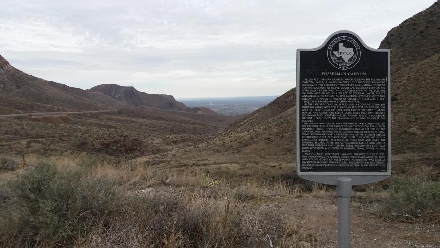
This climb is on Hwy 375 which is also known as Woodrow Bean Transmountain Drive with Smugglers Pass at the top. Hwy 375 is very busy highway (more freeway, actually) and is not the climb for those who are nervous around fast moving traffic. The name “Smugglers Pass” comes from the early frontier days of El Paso when cattle smugglers would drive their stolen goods through Fusselman Canyon (named after a Texas Ranger slain while tracking smugglers in the canyon) and over Smugglers Pass on to Rio Grande Bosque.
El Paso is on the Rio Grande River and is indistinguishable from Ciudad Juarez, Mexico, when viewed on a satellite map.
Thanks much to Dan Razum, Campbell, California, USA for the following climb summaries and all photos for these climbs.
SMUGGLERS PASS WEST

Bike friendly, for what it’s worth . . .
The climb starts where route 375 and Interstate 10 meet. We started on the westbound side of route 375, where
there is a nice bike lane. You could also start on the eastbound side of route 375 but you would ride on the
shoulder instead. However, it's not a bad idea to just start on the eastbound side because the first couple of
miles you ride on the frontage road of 375 and the traffic is light. And the bike lane ends eventually, so you
have no choice but to ride the shoulder of the eastbound side to complete the ride.

Climb begins on a bike path.
Anyway, we started riding on the bike lane along the westbound side. The bike lane is nice and smooth but
unfortunately it ends at the entrance to Franklin Mountains State Park, about half way up the climb. So it seems
that the bike lane is only designed to reach the State Park and if we want to continue the climb then we have
to get to the eastbound side of 375 and carry on. Upon reaching the end of the bike path there is a small
parking lot and an access road leading into the State Park. There is also a trail with a pedestrian underpass
a couple hundred yards away, where we can safely reach the eastbound side of 375. However, it is a little
tedious to actually use the underpass. The trail from the underpass leads to the State Park as well, so
presumably the trail and the access road meet up at some point and we can ride the access road until it reaches
the trail and then ride the trail back under the highway. However, after riding along the access road a few
hundred yards we didn't see where the trail and the access road meet, so we decided to ride back to the parking
lot and just walk to the trail. There isn't a path between the parking lot and the trail, so we just carried our
bikes a couple hundred yards through the desert. Upon reaching the trail, we then crossed under 375. The trail
is paved, but it is a very rough chip-seal and some of the small rocks in the chipseal looked as if they had sharp
edges. It would probably be ok on a mountain bike but we didn't want to risk getting a puncture on our road bike
tires so we walked our bike instead. There were also some large stones just under the highway, limiting access to
pedestrians and narrow items, such as bicycles. The trail wraps around and meets up with the main roadway, where
there are also some posts blocking access to cars and other vehicles, such as ATVs. It is a little puzzling why
there were rocks limiting access under the highway when there were already posts at the entrance of the trail
to limit access.

End of the bike path

Trail from bike path to highway

Connect with the highway after a short hike or ride on gravel path.
Looking back, it would probably have been better to just start on the eastbound side of 375 in the first place.
The bike lane was nice, but it wasn't simple to cross the highway after the bike lane ended. And if we had
ridden up the access road until it eventually met up with the trail, we would have walked the trail back to the
underpass, due to the rough surface.
After we got onto the eastbound side of the highway, we continued riding along the shoulder. The shoulder is
wide and extends the entire length of the climb, along both sides of the highway, and it is also marked as a bike
lane. However, there is significant amounts of debris in some sections and there is a large amount of traffic
along this highway, so you have no choice but to stay in the shoulder. During the ascent you are going slow
enough that the debris isn't much of a problem, but during the descent (on the westbound side) dodging the
debris is a little nerve wracking and it makes you use your brakes a bit more than you might otherwise want to.
The entire climb is along the side of the mountain, up to the pass and you can basically see your destination
right at the start. There aren't any sharp curves and while you do get a chance to look out over the valley as
you climb, the scenery isn't that spectacular and you don't really see much of the beauty of the mountains. The
scenery is better on the other side, coming up Transmountain East.

Nice shoulder.
Just short of the crest there is a u-turn lane and a large picnic area. You can stop at the picnic area to
admire the views and decide if you want to risk a u-turn through 4 lanes of heavy traffic or if you just want
to continue on and descent the other side of the mountain instead. There was a lot of traffic the entire time
we rode 375 so we didn't attempt to cross the road at the summit. So if you only plan to climb one side of the
moutain and descent back down, you should take into account it might be sketchy to cross the road. And we
certainly can't recommend descending against traffic, that could be quite dangerous.

Picnic area and viewpoint near the Smugglers Pass.
Overall, the climb is a good workout and there is a wide shoulder the entire way. But there is a lot of traffic
moving quickly so make sure you are comfortable riding in traffic before you do this climb. A flashing rear
light and mirrors are recommended.
SMUGGLERS PASS EAST

Start
The climb starts at the intersection of route 54 and route 375. Route 375 goes up and over the mountains and
connects with Interstate 10. It is a 4-lane divided highway with heavy traffic. We start along the frontage
road portion which soon merges with the main highway.

Merge onto highway.
There is a wide shoulder the entire way, which is marked as a bike path throughout, but unfortunately there is a lot of gravel and debris in some areas, the shoulder hadn't been cleaned or swept in a while. There was a lot of traffic and at first we thought it was just rush hour traffic, but the traffic did not decrease during the couple of hours we were riding so we assume that traffic is always heavy along this highway. The wide shoulder and bike lane markings are nice, but the high speed of the traffic whizzing by and the debris on the shoulder demand caution and alertness when riding.

Wide bike lane, but fast moving traffic to our left the entire ride.
The rugged mountains provide beautiful scenery. There isn't much opportunity to commune with nature because of
the traffic noise, but the visuals of the mountains and the exposed rocks are still very nice. This section of the Transmountain Drive there are many road cuts in the mountain that expose outcrops of Precambrian rocks which are some of the oldest in Texas.

Precambrian rock exposed by highway contstruction.
It's probably best to take in the sights in the morning or evening; once the sun is high there is no shade and there is also no water along the route.
Just after reaching the crest there is a crossover and a picnic area on the opposite side of the highway.
However, the crossover requires you to cross traffic from both directions, without any lights or signs to slow
the speed of the cars. During our ride, this just wasn't possible and so we continued along 375 and descended
to Interstate 10. If you don't want to go all the way to Interstate 10 there is a pedestrian underpass at the
entrance to Franklin Mountains State Park where you can safely cross the highway, about halfway down the
backside of 375. So just keep in mind that if you only want to climb one side of 375 it may be difficult to
turn around at the top.

Smugglers Pass - a lot of traffic on this climb.

Fusselman Canyon named after Texas Ranger shot and killed tracking smugglers in 1890.
The climb itself is a good workout and the mountain scenery is nice. There is a wide shoulder and no blind
curves so we wouldn't call the road dangerous but we also can't call it safe. If you are not comfortable riding
next to high speed traffic then this may not be appropriate for you.