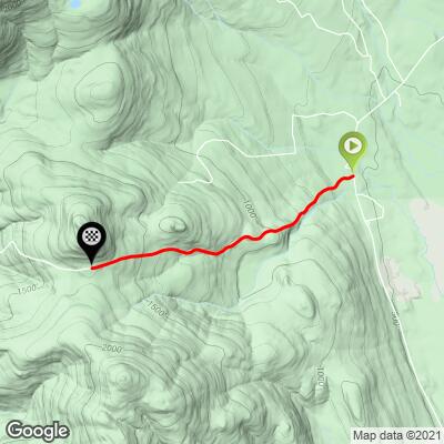
Hurricane Mt. Road East Bike Climb - PJAMM Cycling

3.7
FIETS
2.3 mi
DISTANCE
1,205 ft
GAINED
10 %
AVG. GRADE

FULL CLIMB STATS

Page Contributor(s): John Summerson, The Complete Guide to Climbing (By Bike), 2nd Edition

INTRO

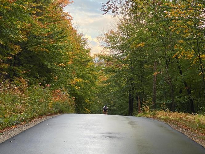
This is a very fun bike climb that will get your attention, not to mention it's quite a beautiful ride during fall colors.  We highly recommend this climb along with Hurricane Mt. Road West if you are visiting or live in the White Mountains of New Hampshire. 

"The east side of Hurricane Mountain Road can also be considered must do for the serious climber. Steep over much of its course, the route is also along a dark in places and always narrow road. A variable grade can make this route difficult bit its relatively short length ensures most will get to its scenic top with its hiking possibilities.” (This quote is provided with the approval of John Summerson from his book, The Complete Guide to Climbing (by Bike) in the Northeast, pg. 96.)
9.9% average grade (10.2% climb only).  35% of the climb is at 10-15% and a sobering 14% is at 15-20% (see Garmin photo at "Full Summary").  Steepest quarter-mile is 15.9%.

See more details and tools regarding this climb's grade via the “Profile Tool” button.
Roadway:  Narrow two lane road with no center striping or shoulder in very good condition. 

Traffic:  Minimal.

Parking:  Near the start of the climb (Map).
Provisions:  None on or near the climb - try Conway 14 miles west (Map). 
Before heading out on any cycling adventure check out our Things to Bring on a Cycling Trip and use our interactive check list to ensure you don't forget anything.
This climb is in the exceptional White Mountains of New Hampshire.  See our White Mountains, NH climb area page.  

Use the “Routes in Area” button on the menu bar to see other bike climbs in this area. 

ROUTE MAP

MEMBER RATING

Not Yet Rated
-
Road
-
Traffic
-
Scenery

CURRENT WEATHER

PJAMM TRIPS ADVENTURE STARTER BUNDLES

Check out PJAMM Adventure's prepackaged (self-guided) cycling trips. They will help you plan, document and conquer your next adventure.
ALL TRIPS
Browse all of our prepackaged trips and find your next adventure!
Mt. Washington Auto Road Race
United States (MA,ME,NH,VT)
3 ROUTES
23 POIs
ROUTE STATS (TOTAL)
7.4
mi
DISTANCE
4,678
ft
ELEV. GAIN
Northeast Fall Colors
United States (MA,ME,NH,NY,VT)
24 ROUTES
37 POIs
ROUTE STATS (TOTAL)
98
mi
DISTANCE
35,116
ft
ELEV. GAIN

NEARBY CLIMBS (0) RADIAL PROXIMITY

FROM
No Climbs Found

MEMBER REVIEWS & COMMENTS

Let us know what you thought of this climb. Signup for our FREE membership to write a review or post a comment.
Already have an account?
ROUTE MAP
PROFILE TOOL
Route Data
S.G. (%)
hide
Segment Data
hide

Climb Profile Not Found
CLIMB SUMMARY

Cycling Hurricane Road East, New Hampshire - cyclist riding on one-lane road surrounded in dense forestation, sunlight coming through forest behind him

Cycling Hurricane Mountain Road East, New Hampshire

Ride 2.3 miles gaining 1,195’ at 10% average grade.

Climb summary by PJAMM’s John Johnson.

This is the harder of the two routes up to the top of Hurricane Mountain Road, although the western approach is also very challenging.  Both climbs are exceptional -- we rank them as nearly epic, actually.  While short, these are brutal bike climbs up very steep grades.  The steepest quarter mile is 16% and steepest half mile is 13.6%.

Cycling Hurricane Road East, New Hampshire - photo collage,  Garmin device reading 19% grade, one-lane, wet roadway surrounded in forestation and fall foliage, PJAMM Cycling logo in corner

“The east side of Hurricane Mountain Road can also be considered must do for the serious climber.  Steep over much of its course, the route is also along a dark in places and always narrow road.  A variable grade can make this route difficult bit its relatively short length ensures most will get to its scenic top with its hiking possibilities.” (This quote is provided with the approval of John Summerson from his book, The Complete Guide to Climbing (by Bike) in the Northeast, pg. 96.)

Cycling Hurricane Road East, New Hampshire - narrow, one-lane, pristinely paved roadway surrounded by tree cover, PJAMM Cycling logo in corner

Roadway surface is excellent and there is minimal traffic on this climb.

Cycling Hurricane Road East, New Hampshire - cyclist riding on one-lane, wet, pristinely paved roadway surrounded by thick forestation, PJAMM Cycling logo in corner

We are surrounded by thick forest the entire climb.

This side of the climb is almost entirely within Conway Common Lands State Forest.

Cycling Hurricane Road East, New Hampshire - PJAMM Adventure App showing climb grade and overview

PJAMM Adventure App.

Purple sections denote 18+% segments of climbing.

Cycling Hurricane Road East, New Hampshire - two cyclists stand on one-lane roadway at climb's finish, surrounded by dense forestation, sunlight peeking through trees

Finish of the eastern and western approaches.

Hurricane Mountain is located in New Hampshire’s amazing White Mountains.  Visit our White Mountains Fall Colors Climb Page for more information on this area.

That’s a wrap!

Access to full Climb Summary requires a PJAMM Cycling PRO Membership!

It takes less than a minute to sign up & with your PRO membership you can:
  • Rate climbs, post comments and share your experiences on any of our climb pages
  • Create bucket lists of climbs & mark the dates you complete them
  • Weather data for all climbs - Start & Finish
  • Upload photos to your member page to customize your PJAMM Cycling experience
  • Utilize all of our interactive tools - Profile & Routes in Area
  • Download climb route .gpx files
LEARN MORE
SIGN UP

Already have an account? LOG IN HERE