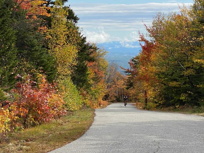
![Cycling Kearsarge Mountain Road, New Hampshire Cycling Kearsarge Mountain Road, New Hampshire - panoramic view looking down hillside covered in fall foliage]()
Cycling Kearsarge Mountain Road, New Hampshire
Ride 3.5 miles gaining 1,470’ at 8% average grade.
This is the third hardest bike climb in New Hampshire and may be the most scenic -- particularly during leaf peeping season. 👍👍 It is said that on a clear day the skyscrapers of Boston can be seen 80 miles away. While we could see Boston from Wachusetts Mountain on our trip there, we could not spot it from Mt. Kearsarge on the October day we rode this beauty. Mt. Kearsarge is the southernmost of New Hampshire’s top bike climbs located in the White Mountains.
![Cycling Kearsarge Mountain Road, New Hampshire Cycling Kearsarge Mountain Road, New Hampshire - photo collage, dense and bright colored fall foliage, Garmin device showing 22% grade, PJAMM Cycling logo in corner]()
There are some brief extremely steep sections (22% is the highest grade I encountered).
The steepest quarter mile (13.6%) and half mile (12.8%) begin about a quarter mile from the start.
“Kearsarge Mountain Road is a solid climb in central New Hampshire within Rollins State Park. Very narrow and twisty, it is also through a dark tunnel of trees over its lower end. It carries a stout and variable grade over much of its route and is double digit in places. Towards the top the trees thin in spots which provide views on clear days. The grade eases a bit as well over the 2nd half and the ascent ends at a parking lot. Because of its characteristics it is a somewhat difficult but fun descent.” (This quote is provided with the approval of John Summerson from his book The Complete Guide to Climbing (By Bike), 2nd Edition, pg. 76.)
![Cycling Kearsarge Mountain Road, New Hampshire Cycling Kearsarge Mountain Road, New Hampshire - historical monument, informational sign regarding Mount Kearsarge and the USS Kearsarge]()
The ride can begin in Kearsarge, five miles from the true start of the climb.
The scenery is very nice on the way to the climb.
![Cycling Kearsarge Mountain Road, New Hampshire Cycling Kearsarge Mountain Road, New Hampshire - toll at climb's start]()
$4.00 entrance fee as of October 2020.
We parked just outside the park, but cyclists and hikers must pay an entry fee.
This bike climb is completely within Mt. Kearsarge State Forest Park, and we begin our climb at the entrance to Rollins State Park, fully within the State Forest. The climb is up Mt. Kearsarge, with a peak of 2,937 feet, although our climb ends at the upper parking lot at just over 2,600 feet.
![Cycling Kearsarge Mountain Road, New Hampshire Cycling Kearsarge Mountain Road, New Hampshire - PJAMM Cyclists riding on bike path through dense bright yellow fall foliage]()
We were fortunate to ride during the peak of fall colors.
The name “Kearsarge” derives from the native Pennacook word Carasarga, which means “mountain.”
![Cycling Kearsarge Mountain Road, New Hampshire Cycling Kearsarge Mountain Road, New Hampshire - bike parked next to a sign for bear crossing on first third of climb, dense fall foliage, PJAMM cycling logo in corner]()
First third of the climb.
![Cycling Kearsarge Mountain Road, New Hampshire Cycling Kearsarge Mountain Road, New Hampshire - bright red and yellow foliage along one-lane roadway in middle of climb]()
Middle of the climb.
![Cycling Kearsarge Mountain Road, New Hampshire Cycling Kearsarge Mountain Road, New Hampshire - photo collage, PJAMM Cyclists climbing on one-lane roadway into hills surrounded by dense fall foliage, PJAMM Cycling logo in corner]()
Last third of this climb.
![Cycling Kearsarge Mountain Road, New Hampshire Cycling Kearsarge Mountain Road, New Hampshire - PJAMM Adventure App showing climb grade and overview]()
PJAMM App shows the grade, with one brief descent along the way.
![Cycling Kearsarge Mountain Road, New Hampshire Cycling Kearsarge Mountain Road, New Hampshire - two PJAMM Cyclists stand with bikes atop finish Kearsarge Mountain Road, views behind them are panoramic of dense and bright fall foliage, mountains in background]()
Climb’s Finish.
![Cycling Kearsarge Mountain Road, New Hampshire Cycling Kearsarge Mountain Road, New Hampshire - bike parked against a large rock overlooking gorgeous panoramic views down hillside covered with dense fall foliage, picnic benches, hiking trails, PJAMM Cycling logo in corner]()
There are a parking lot, picnic benches, and a hiking trail at the top.
![]()
That’s a wrap!

 We've partnered with Sherpa-Map.com to bring you the best route planning tool. With a PRO Membership you can use this climb as a reference when creating your route.


