
54.3
PDI
37.6 mi
DISTANCE
10,119 ft
GAINED
4.7 %
AVG. GRADE
FULL CLIMB STATS
Page Contributor(s): Josue Rodriguez, CO
INTRO
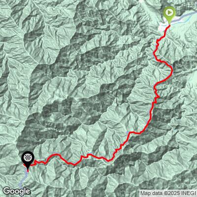
Llano de las Flores is a 37.6-mile, 10,119-foot bike climb in the Sierra Juarez mountains of northern Oaxaca, Mexico. Starting in the humid lowland town of Valle Nacional at just 287 feet of elevation, the road climbs almost continuously along Federal Highway 175 to the high plateau of Llano de las Flores, topping out near 9,599 feet at an average gradient of 4.7%.
It is the hardest bike climb in Mexico in our (admittedly incomplete) database of the country's climbs, and the 31st hardest climb in the world (PDI 54.3). Few climbs anywhere combine this much vertical gain with this much environmental range - riders leave steamy tropical rainforest near Valle Nacional and finish among cool pine-oak forest more typical of a much higher latitude, all in one continuous effort.
Llano de las Flores itself is better known locally as a Sierra Norte ecotourism destination - a high mountain meadow ringed by pine and oak forest, with waterfalls and caves nearby - than as a cycling objective.
Highway 175 here is also prone to seasonal landslide damage; a major slide closed the Valle Nacional-Oaxaca section in October 2025, and a state rehabilitation project for this corridor was announced in early 2026, so check current road conditions before setting out.
PLAN YOUR ROUTE
 We've partnered with Sherpa-Map.com to bring you the best route planning tool. With a PRO Membership you can use this climb as a reference when creating your route.
 This climb's 4.7% average obscures real variation across 37.6 miles. The steepest quarter mile comes in at 14.9%, and the single steepest 100 yards hits 15.4% - short, punchy ramps rather than sustained wall sections. Zoomed out, the steepest 5-mile stretch still averages 8.9%, so parts of this climb hold a genuinely hard grade over a meaningful distance, not just a brief kicker.
Per a rider who completed the full climb in 2025, the toughest test comes late: the first roughly 30 miles are manageable, with the final few miles kicking up noticeably as the road tops out onto the Llano de las Flores plateau. Pace conservatively through the long lower and middle sections so you have something left for the finish.
Roadway: This climb follows Federal Highway 175 (the Oaxaca-Tuxtepec highway), which is paved the entire way. A rider who completed the climb in 2025 described the asphalt as in good condition overall. That said, this stretch of the Sierra Juarez is prone to seasonal landslide damage - a major slide fully closed the Valle Nacional-Oaxaca section of Hwy 175 at kilometer 62 in October 2025 after heavy rains, and Oaxaca's state government announced a 20-kilometer rehabilitation project for this corridor in early 2026. Check current road conditions before riding, especially during rainy season (roughly June through October).
Traffic: Reported as low to moderate, with drivers described as courteous. Highway 175 here is a real transit route between Tuxtepec and Oaxaca City, not a closed backroad, so expect some truck and bus traffic mixed with light local use, particularly closer to the Valle Nacional lowlands.
Parking: There's no dedicated parking area at the base. Riders typically start from the vicinity of Valle Nacional's town plaza, where informal street parking is available. There are no other services or parking areas along the 37 miles to the summit, so plan your logistics, including return transport, before you start.
This climb crosses an unusually wide range of conditions in one ride, so pack for both ends of it. Down at Valle Nacional, expect hot, humid, rainforest-like heat, especially later in the day; a rider who completed this climb in 2025 recommended starting early for exactly this reason.
As the road climbs into the pine-oak forest near the top, temperatures drop noticeably, so carry a real layer (a light jacket or arm/leg warmers) for the upper miles or any extended time at altitude.
Provisions are available in Valle Nacional itself before you start - it's a real town with shops and places to eat - but there's essentially nothing along the climb's 37-plus miles until you reach the top, so carry all the food and water you'll need for a multi-hour effort. A support vehicle is worth considering given how remote and long this climb is.
Before heading out on any cycling adventure check out our Things to Bring on a Cycling Trip and use our interactive check list to ensure you don't forget anything.
Llano de las Flores is a legitimate Oaxacan tourist destination in its own right - a high mountain meadow with pine-oak forest, waterfalls (including the Velo de Novia falls), and caves - so it's worth treating the summit as more than just a turnaround point. Oaxaca City is reached via Highway 175 through Ixtlan de Juarez, roughly 80 km and over 2 hours away by car, so most riders will base out of Oaxaca City, Tuxtepec, or Valle Nacional itself rather than attempting this as a day trip from farther afield.
This is a remote, high-commitment climb - cell service and services are limited for long stretches, and the road shares space with regular highway traffic including buses and trucks. Given the elevation range (near sea level to nearly 9,600 feet) and the length, treat this as a full-day effort and plan hydration, nutrition, and return transportation accordingly.
ROUTE MAP
MEMBER RATING
CURRENT WEATHER
PJAMM TRIPS ADVENTURE STARTER BUNDLES
Check out PJAMM Adventure's prepackaged (self-guided) cycling trips. They will help you plan, document and conquer your next adventure.
NEARBY CLIMBS (0) RADIAL PROXIMITY
FROM No Climbs Found
MEMBER REVIEWS & COMMENTS
Let us know what you thought of this climb. Signup for our FREE membership to write a review or post a comment.
Already have an account?
LOG IN HERE
JosueR
Wow!! What a fantastic climb. Not too steep except for the last few miles which after climbing for about 30 miles are a bit challenging. Asphalt is in overall good condition with low to moderate traffic. All vehicles were very courteous and most even provided encouragement. This climb starts in a rainforest environment which can be quite hot later in the day, starting early is key. Bring layers for the top as it turns into a heavily vegetated pine forest and can be a lot cooler than the start.
