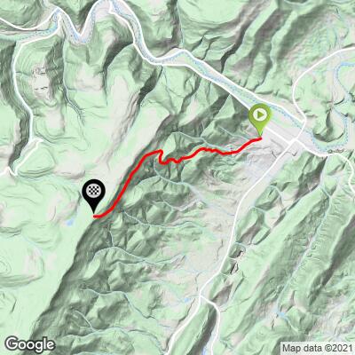
Woodland Lane (Parkview) Bike Climb - PJAMM Cycling

3.9
FIETS
4.7 mi
DISTANCE
1,803 ft
GAINED
7.2 %
AVG. GRADE

FULL CLIMB STATS

Page Contributor(s): John Summerson, The Complete Guide to Climbing (by Bike), 2nd Edition.

INTRO

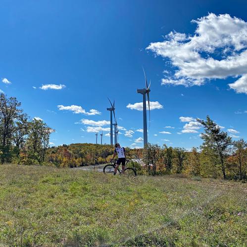
"Woodland Lane is a very solid climb...In town to start, you begin over shallow grade which gradually steepens as you head west. Just over a half mile into the ascent the road leaves town and dives into the thick woods and you ride through a tunnel of trees for much of the remainder of the hill. The grade at this point also changes as it becomes quite stout and close to double digit on average. The road swings through graceful curves on this section as well which you may not fully appreciate...The tight roadway and tree cover makes for an interesting ride but the road carries little traffic most of the time. The grade eases over the last mile or so before you finish at an unmarked summit. (This quote is provided with the approval of John Summerson from his book, The Complete Guide to Climbing (by Bike), 2nd Edition, pg. 100.)

See more details and tools regarding this climb's grade via our interactive Profile Tool.
Information Not Available

If you have any information regarding this climb, we'd like to hear from you. Click the CONTRIBUTE button to share your thoughts with us.

Information Not Available

If you have any information regarding this climb, we'd like to hear from you. Click the CONTRIBUTE button to share your thoughts with us.

Before heading out on any cycling adventure check out our Things to Bring on a Cycling Trip and use our interactive check list to ensure you don't forget anything.
Information Not Available

If you have any information regarding this climb, we'd like to hear from you. Click the CONTRIBUTE button to share your thoughts with us.

ROUTE MAP

MEMBER RATING

Not Yet Rated
-
Road
-
Traffic
-
Scenery

CURRENT WEATHER

PJAMM TRIPS ADVENTURE STARTER BUNDLES

Check out PJAMM Adventure's prepackaged (self-guided) cycling trips. They will help you plan, document and conquer your next adventure.
ALL TRIPS
Browse all of our prepackaged trips and find your next adventure!
Smoky Mountain National Park
United States (NC,TN)
17 ROUTES
31 POIs
ROUTE STATS (TOTAL)
181.8
mi
DISTANCE
34,253
ft
ELEV. GAIN
The Blue Ridge Parkway (North)
United States (NC,TN,VA)
38 ROUTES
70 POIs
ROUTE STATS (TOTAL)
716.5
mi
DISTANCE
75,697
ft
ELEV. GAIN
The Blue Ridge Parkway (South)
United States (NC,TN,VA)
30 ROUTES
63 POIs
ROUTE STATS (TOTAL)
690.7
mi
DISTANCE
74,180
ft
ELEV. GAIN

NEARBY CLIMBS (0) RADIAL PROXIMITY

FROM
No Climbs Found

MEMBER REVIEWS & COMMENTS

Let us know what you thought of this climb. Signup for our FREE membership to write a review or post a comment.
Already have an account?
ROUTE MAP
PROFILE TOOL
Route Data
S.G. (%)
hide
Segment Data
hide

Climb Profile Not Found
CLIMB SUMMARY

Cycling Woodland Lane, West Virginia - cyclist rides on two-lane roadway surrounded by fall foliage, tall windmill in distance peaks over the trees

Cycling Woodland Lane, West Virginia

Ride 4.7 miles gaining 1,756’ at 7% average grade.

This was our favorite West Virginia climb and one of our favorites of our 12 state fall colors 2020 trip.  The climb is very challenging, extraordinarily beautiful (at least during fall colors), and boasts a super cool finish in the heart of a windmill farm.  A word to the wise: be ready from the start!  After a very brief shallow entry, we hit 2.4 miles at 10.2% average, briefly exceeding 20%.

Cycling Woodland Lane, West Virginia - cyclist climbs on two-lane roadway surrounded by fall foliage, Garmin device reads 22% grade, windmill seen in distance, PJAMM cycling logo in corner

STEEEEEEP!

Road is a narrow two-laner with mild traffic.

“Woodland Lane is a very solid climb away from Keyser, West Virginia in the far northern part of the state.  In town to start, you begin over shallow grade which gradually steepens as you head west.  Just over a half mile into the ascent the road leaves town and dives into the thick woods and you ride through a tunnel of trees for much of the remainder of the hill.  The grade at this point also changes as it becomes quite stout and close to double digit on average.  The road swings through graceful curves on this section as well which you may not fully appreciate unless you also descend the route.  The tight roadway and tree cover makes for an interesting ride but the road carries little traffic most of the time.  The grade eases over the last mile or so before you finish at an unmarked summit.  Its sweeping turns and stout grade also create a quick an somewhat technical descent in spots. There is other interesting riding/climbing in this scenic area.”  (This quote is provided with the approval of John Summerson from his book, The Complete Guide to Climbing (by Bike), 2nd Edition, pg. 100.)

Cycling Woodland Lane, West Virginia - climb start in Keyser, West Virginia, PJAMM Cycling logo in corner

Don’t judge a book by a cover -- this one is extremely scenic and epic.

Cycling Woodland Lane, West Virginia - PJAMM Adventure App shows climb grade and profile

PJAMM Adventure App with stats at the start.

Cycling Woodland Lane, West Virginia - fall foliage, bright blue skies, and windmills on center part of climb

Middle part of the climb.

Cycling Woodland Lane, West Virginia - fall foliage, bright blue skies, and windmills on last half of bike climb

Last half of the climb.

Cycling Woodland Lane, West Virginia - climb finish at Mount Storm Wind Farm, huge, white windmills everywhere

Mount Storm Wind Farm -- 132 wind turbines constructed in 2006.