
24.6
PDI
8.1 mi
DISTANCE
3,478 ft
GAINED
8.1 %
AVG. GRADE
FULL CLIMB STATS
INTRO
PLAN YOUR ROUTE
 We've partnered with Sherpa-Map.com to bring you the best route planning tool. With a PRO Membership you can use this climb as a reference when creating your route.
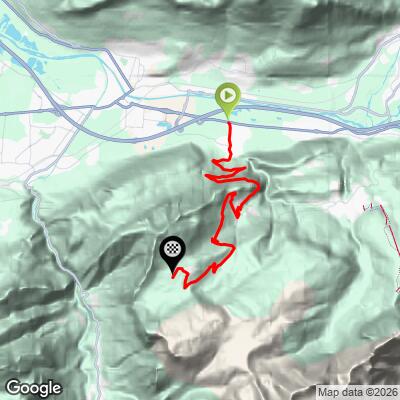
 From Thuet to the Plateau de Solaison, the route covers 13.1 km (8.1 mi) and climbs 1,060 m (3,478 ft) at an average grade of 8.1%.
The road starts gently for the first kilometer or so out of the valley before pitching up hard - the steepest kilometer averages 10.7%, and the steepest 100 yards spikes to 12.7%. From there the climb holds a sustained, punishing rhythm: the hardest 5 km average just over 10%, and even the hardest 10 km - most of the route - still averages 9.2%. There's essentially no flat or downhill relief anywhere on the way up.
Roadway: Despite the relentless gradient, the pavement is in good condition the whole way up - it's narrow but well maintained, kept smooth enough that even the steepest pitches don't feel rough underneath you. There's no vehicle through-traffic to justify constant repaving, but the road doubles as access for hikers and cross-country skiers heading to the plateau, so it's kept in reasonable shape year-round.
Traffic: This is a dead-end road with no through-route over the mountain, so traffic is minimal - mostly a handful of cars headed up to the restaurants and trailheads on the plateau. Expect calm, quiet riding for essentially the entire climb.
Parking: There's space to park in Thuet at the base of the climb, right where the road pitches up out of the valley. At the top, the plateau itself has a parking area near the restaurants and the trailheads that continue on foot.
There's a fountain at the base of the climb in Thuet and another at the top, directly across from the summit marker, so you can top off water at both ends even though there's nothing in between. A handful of restaurants sit on the plateau at the finish if you want food after the effort, but bring what you need for the climb itself - there's nothing on the mountain in between.
This is a climbing day, not a spinning one: gear low, since the road holds double-digit grades for long stretches with essentially no flat sections to recover on. The upper mountain is shaded and north-facing, so it can run noticeably colder than the valley floor even in summer - worth a light jacket for the descent.
Before heading out on any cycling adventure check out our Things to Bring on a Cycling Trip and use our interactive check list to ensure you don't forget anything.
Bonneville sits in the Arve valley at the foot of the climb, with hotels, restaurants, and bike shops for anything you need before or after.
Solaison shares the broader Massif des Bornes with the Col de la Colombière and the Col des Aravis, both a short drive away - if you're basing yourself in the Bonneville/Cluses area for a few days, they pair naturally with Solaison for a varied block of Alpine climbing. The mountain is also popular with hikers and, in winter, cross-country skiers, who share the same plateau at the top.
Riders looking to string together a longer day can check our Routes in the Area tool to see what else is nearby.
ROUTE MAP
MEMBER RATING
CURRENT WEATHER
PJAMM TRIPS ADVENTURE STARTER BUNDLES
Check out PJAMM Adventure's prepackaged (self-guided) cycling trips. They will help you plan, document and conquer your next adventure.
NEARBY CLIMBS (0) RADIAL PROXIMITY
FROM No Climbs Found
MEMBER REVIEWS & COMMENTS
Let us know what you thought of this climb. Signup for our FREE membership to write a review or post a comment.
Already have an account?
LOG IN HERE
