
21.5
PDI
1.5 mi
DISTANCE
1,471 ft
GAINED
19.1 %
AVG. GRADE
FULL CLIMB STATS
INTRO
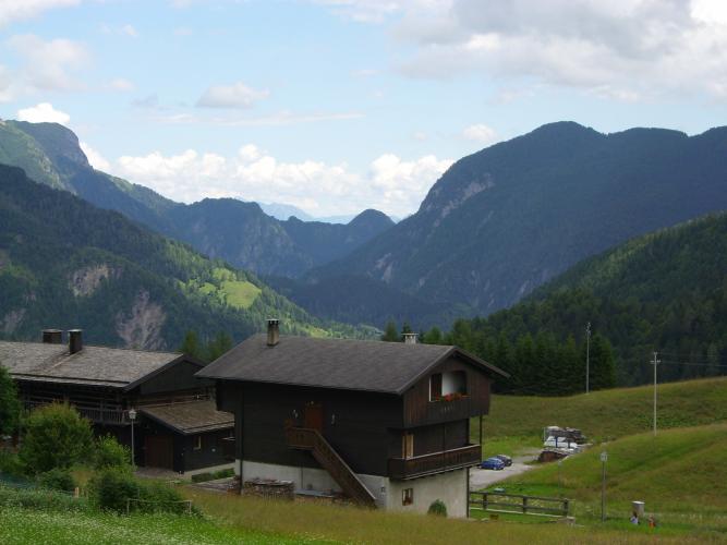
Sella Festons is a short, savage climb out of Sauris di Sopra: 2.4 km (1.5 mi) gaining 448 m (1,471 ft) at a 19.1% average grade, up to the saddle where Malga Festons sits at 1830 m (6,004 ft), between the Sauris valley and Val Pesarina. There is no flat section anywhere on it.
We'd call it a steep goat path with unpredictable pavement. There isn't a lot to say in its favor other than the setting, which is the Carnic Alps with Dolomite views opening up above the village. If you want to cook your legs before the second half of Sella di Rioda, go for it.
The road is only partly paved and, according to the Sauris tourist board, is closed to tourist vehicles, so it is quiet. It climbs through mountain pastures to the saddle, close to the Festons ponds, a high plateau at around 1880 m (6,168 ft) that is a surprise at this altitude.
PLAN YOUR ROUTE
 We've partnered with Sherpa-Map.com to bring you the best route planning tool. With a PRO Membership you can use this climb as a reference when creating your route.
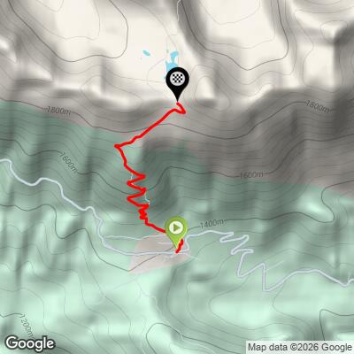
Our route covers 2.4 km (1.5 mi) from 1,399 m (4,590 ft) to 1,847 m (6,061 ft), a gain of 448 m (1,471 ft) at 19.1% on average. The first 1.5 km (0.9 mi) run at 20.6-21.8% with no break, then it eases to about 15% before a final ramp of about 16%.
The steepest 100 yards (91 m) reach 25.0%, the steepest quarter-mile (0.4 km) averages 22.7%, the steepest half-kilometer (0.3 mi) averages 22.2%, and the steepest 1 km (0.6 mi) averages 21.8%. Even the full 2 km (1.2 mi) averages 19.5%, so this is a climb about gearing and pacing.
Roadway: The road is only partly paved, with broken pavement and gravel patches, though it is rideable on a road bike. The Sauris tourist board lists it as closed to tourist vehicles, so check the signs at the start for any restriction before riding.
Traffic: Traffic is minimal, mostly local farm and alpine hut vehicles, since the road is closed to tourist vehicles.
Parking: The road starts from the village of Sauris di Sopra, around the central square at roughly 1400 m (4,590 ft), so park in the village and keep driveways and farm access clear. A small parking area at the western end of Sauris di Sopra is the usual trailhead for hikers heading up toward the saddle.
Bring the lowest gearing you own: a compact crankset with a 34-tooth rear cog is a sensible minimum for 19.1% on average, and wider tires help on the gravel patches. Brakes should be in good shape for the descent, which is steep and can be loose where the pavement breaks up.
There is no shop on the climb. Malga Festons at the saddle, a mountain hut at 1830 m (6,004 ft) offering local alpine products (contact it before riding, since it keeps seasonal hours), is the only stop. Carry a bottle and a snack from Sauris di Sopra.
Before heading out on any cycling adventure check out our Things to Bring on a Cycling Trip and use our interactive check list to ensure you don't forget anything.
Sauris is known for prosciutto di Sauris, traditionally smoked over beech wood, including the Wolf smokehouse, operating since 1862, and for Zahre beer, named after the village's German name and served at the Casera Festons hut. Those two are the best reasons to stay for a meal after the climb.
The village is built in the historic blockbau style, stone foundations under timber upper floors, and the albergo diffuso spreads its rooms through the village houses. The Festons ponds just past the saddle, at about 1880 m (6,168 ft), are worth a short walk to see.
Our Sella di Rioda page covers the long climb from Lago di Sauris through Sauris di Sotto and Sopra, and our Routes in the Area tool shows how the two fit together as a day.
ROUTE MAP
MEMBER RATING
CURRENT WEATHER
PJAMM TRIPS ADVENTURE STARTER BUNDLES
Check out PJAMM Adventure's prepackaged (self-guided) cycling trips. They will help you plan, document and conquer your next adventure.
NEARBY CLIMBS (0) RADIAL PROXIMITY
FROM No Climbs Found
MEMBER REVIEWS & COMMENTS
Let us know what you thought of this climb. Signup for our FREE membership to write a review or post a comment.
Already have an account?
LOG IN HERE
