
30.4
PDI
17.6 mi
DISTANCE
5,312 ft
GAINED
5.7 %
AVG. GRADE
FULL CLIMB STATS
INTRO
PLAN YOUR ROUTE
 We've partnered with Sherpa-Map.com to bring you the best route planning tool. With a PRO Membership you can use this climb as a reference when creating your route.
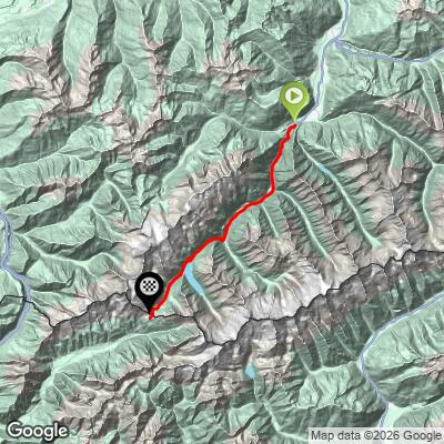
 Passo di Vizze (West) covers 28.3 km (17.6 mi) from 674 m (2,211 ft) to 2,273 m (7,458 ft), gaining 1,619 m (5,312 ft) at an average grade of 5.7%.
That average hides a very uneven profile. The first 13.7 km (8.5 mi) up the valley gain 559 m (1,834 ft) at about 4.1%. The steepest section follows, 2.8 km (1.7 mi) at 9.1% that gains 253 m (830 ft). The road then eases to about 5.2% over the next 5.9 km (3.7 mi) to the reservoir, before the unpaved track above the dam climbs 484 m (1,588 ft) in 5.8 km at roughly 8.3%.
The steepest 100 yards (91 m) average 16.2%, the steepest half-kilometer 15.0%, the steepest kilometer 12.9%, the steepest 5 km 8.9% and the steepest 10 km 7.0%.
Roadway: The valley section is paved. From Ginzling the road becomes the Schlegeis Alpenstraße, a toll road with eight hairpins, four natural stone tunnels and a single-lane stretch controlled by traffic lights. It is open roughly from late May to late October, weather permitting. Rules for bikes on the Alpenstraße itself have varied, and the operator currently points cyclists to a separate forest path, so check before you go. Beyond the dam the surface is an unpaved track.
Traffic: Below Ginzling it is an ordinary valley road with local and tourist traffic. On the Alpenstraße, cars and buses queue for the toll and the single-lane stretch on busy summer days, and on peak days the toll station can reach capacity, so an early start is calmer. The track above the reservoir carries only hikers and the occasional mountain biker.
Parking: Mayrhofen, next door, is the practical place to park or arrive by Zillertalbahn train. If you would like a lift back from the reservoir, bus line 4102 runs from Mayrhofen to the reservoir from June to September.
Provisions: Mountain huts and restaurants line the valley route from roughly 900 m to 1,800 m (2,953 to 5,906 ft), and the Pfitscher-Joch-Haus at the top offers refreshments and a beer garden. Carry water for the unpaved final section.
Gear: Bring bright front and rear lights, since the tunnels range from short to a few hundred meters long. For the last 5.8 km (3.6 mi) a mountain bike and shoes you can walk in are far better than road gear, because you will be carrying the bike in places. The pass is about 1,600 m (5,250 ft) above the start, so typically 10 C (18 F) cooler, and a warm layer is essential.
Before heading out on any cycling adventure check out our Things to Bring on a Cycling Trip and use our interactive check list to ensure you don't forget anything.
Ginzling, the last village before the toll road, is a mountaineering village that serves as the trailhead for the surrounding Zillertal Alps. The Schlegeis dam holds back the reservoir and stands 131 m (430 ft) high, and the reservoir is the starting point for many hikes into the high peaks. The pass itself has carried travelers for thousands of years, and the Pfitscher-Joch-Haus has a view toward the 3,510 m (11,516 ft) Hochfeiler.
The pass is typically rideable July through September. From the Italian side it is climbed from Prati on our Passo di Vizze (Val de Vizze) page. Conditions at the reservoir and pass can differ sharply from Mayrhofen, so check the forecast at the top with our Weather tool before you go.
ROUTE MAP
MEMBER RATING
CURRENT WEATHER
PJAMM TRIPS ADVENTURE STARTER BUNDLES
Check out PJAMM Adventure's prepackaged (self-guided) cycling trips. They will help you plan, document and conquer your next adventure.
NEARBY CLIMBS (0) RADIAL PROXIMITY
FROM No Climbs Found
MEMBER REVIEWS & COMMENTS
Let us know what you thought of this climb. Signup for our FREE membership to write a review or post a comment.
Already have an account?
LOG IN HERE
