
37.4
PDI
9.9 mi
DISTANCE
4,746 ft
GAINED
9 %
AVG. GRADE
FULL CLIMB STATS
INTRO
PLAN YOUR ROUTE
 We've partnered with Sherpa-Map.com to bring you the best route planning tool. With a PRO Membership you can use this climb as a reference when creating your route.
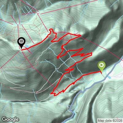
 Penken climbs 16.0 km (9.9 mi) from 645 m (2,117 ft) to 2,081 m (6,827 ft), gaining 1,447 m (4,746 ft) at an average grade of 9.0%.
There is very little rest on the way up. The steepest 100 yards (91 m) average 14.6%, the steepest half-kilometer 14.1%, the steepest kilometer 13.4%, and the steepest 5 km still average 11.5%. Even the steepest 10 km holds 9.6%.
The hardest stretch runs from roughly 7 km to 12 km (4.3 to 7.5 mi), which gains 546 m (1,791 ft) at 10.7%. After the gondola's upper station the closing 3.8 km (2.4 mi) to the Penkenjoch relax to about 7.8% on a gravel road, climbing about 296 m (971 ft).
Roadway: The route uses a mix of paved and gravel surfaces on mountain roads and tracks, and the closing 3.8 km (2.4 mi) above the gondola's upper station is a maintained gravel road. Ride it on a gravel or mountain bike rather than a road bike.
Traffic: There is no through traffic. In summer you share the way with hikers and mountain bikers, including riders coming down from the Mayrhofen Penken bike park, so keep to your side and expect fast descenders on summer weekends.
Parking: Mayrhofen is the Zillertal's main resort village, and the Penkenbahn valley station is in the village. The narrow-gauge Zillertalbahn train terminates in Mayrhofen, which makes arriving by rail an easy way to skip parking altogether.
Provisions: The mountain huts and restaurants near the ridge, including the Penkenjochhaus, Penkentenne and Christa's Schialm, make it easy to travel light on food. Carry your own water and snacks for the lower part of the climb.
Gear: A gravel or mountain bike with wide tires and low gearing is the right choice, since grades reach the mid-teens. The ridge is roughly 1,436 m (4,711 ft) above the start, so typically about 9 C (16 F) cooler, and a wind layer is worth packing. The gravel descent is fast, so wear a helmet and check your brakes before heading down.
Before heading out on any cycling adventure check out our Things to Bring on a Cycling Trip and use our interactive check list to ensure you don't forget anything.
Mayrhofen is the practical base for this climb and for the valley's other long rides. The 3S Penkenbahn carries riders and bikes from the village to about 1,790 m (5,873 ft) in roughly eight minutes, a handy option for a lazy descent or a bad-weather bailout. One rule to know: bikes are not allowed on the Ahornbahn or on Mount Ahorn.
Our Passo di Vizze (West) page covers the long valley ride south from the edge of Mayrhofen to the Schlegeis reservoir. Farther down the valley, the villages of Hippach, Zell am Ziller and Aschau each have steep climbs of their own. See other climbs nearby, or plan a multi-climb day, with our Routes in the Area tool.
ROUTE MAP
MEMBER RATING
CURRENT WEATHER
PJAMM TRIPS ADVENTURE STARTER BUNDLES
Check out PJAMM Adventure's prepackaged (self-guided) cycling trips. They will help you plan, document and conquer your next adventure.
NEARBY CLIMBS (0) RADIAL PROXIMITY
FROM No Climbs Found
MEMBER REVIEWS & COMMENTS
Let us know what you thought of this climb. Signup for our FREE membership to write a review or post a comment.
Already have an account?
LOG IN HERE
