
38.4
PDI
9.2 mi
DISTANCE
4,682 ft
GAINED
9.6 %
AVG. GRADE
FULL CLIMB STATS
INTRO
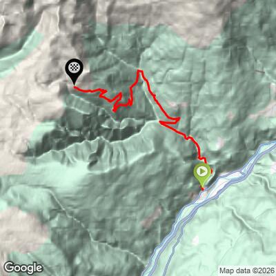
Kaseregg (also spelled Kasereck) is a hard climb from the Isarco Valley town of Chiusa (Klausen) to the Kaseregg car park above the village of Latzfons, the trailhead for the Latzfonser Alm. It covers 14.8 km (9.2 mi) and gains 1,427 m (4,682 ft), from 543 m (1,780 ft) to 1,958 m (6,424 ft), at a 9.6% average grade. That ranks it 123rd on our world difficulty ranking and 13th in Italy.
The climb comes in two parts. The first half winds up through the Latzfons hamlets and eases near km 8 (mi 5.0) at about 1,130 m (3,700 ft). Then the final 6.8 km (4.2 mi) average 12.3%, with the steepest kilometer at 16.6% and a short pitch touching 27.1%.
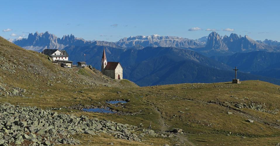
The road ends where the walking begins. Open alpine meadows, the Stöfflhütte and the Latzfonser Kreuz pilgrimage church are all reached on foot from the car park, with Dolomite views opening across the Villanderer Alm to the south.
PLAN YOUR ROUTE
 We've partnered with Sherpa-Map.com to bring you the best route planning tool. With a PRO Membership you can use this climb as a reference when creating your route.
 Kaseregg climbs 1,427 m (4,682 ft) in 14.8 km (9.2 mi), from 543 m (1,780 ft) at the edge of Chiusa to 1,958 m (6,424 ft) at the Kaseregg car park, averaging 9.6%.
The profile is really two climbs. The first 8 km (5.0 mi) rise at 7.3% to about 1,130 m (3,700 ft) near Latzfons, with km 8 the easiest kilometer at 4.3%. The last 6.8 km (4.2 mi) average 12.3% and gain about 830 m (2,730 ft), and every kilometer from km 9 (mi 5.6) to the top runs above 10%.
Steepest stretches: 100 yd (91 m) at 27.1%, 0.5 km (0.3 mi) at 20.0%, 1 km (0.6 mi) at 16.6%, 2 km (1.2 mi) at 13.7%, 5 km (3.1 mi) at 12.8%, and 10 km (6.2 mi) at 10.7%.
Roadway: The route follows the public road from Chiusa through the Latzfons hamlets to the Kaseregg car park, where traffic ends and the hiking trails begin. The finish sits near 1,960 m (6,430 ft), so snow can linger into spring and return early in autumn. From December to March a groomed natural toboggan run of 2.3 km (1.4 mi) operates from the Öberst car park (1,686 m / 5,531 ft) to the Jochalm dairy at about 1,965 m (6,447 ft), so treat the upper slopes as winter terrain outside the summer season.
Traffic: Mostly local: residents of Latzfons and its farms, plus hikers driving up to the Kaseregg trailhead for the Latzfonser Kreuz and Stöfflhütte walks.
Parking: Chiusa has a railway station with the bus terminal beside it, a short ride from the foot of the climb and the same base as our Rifugio Gasser climb. Buses 342 and 343 also link Klausen with Latzfons. At the top, the Kaseregg car park at about 1,940 m to 1,960 m (6,365 ft to 6,430 ft) is where drivers leave their cars for the hikes.
Gear: Go low. A 34-tooth chainring with a 34-tooth rear sprocket, or an even lower ratio, is a sensible choice for 6.8 km (4.2 mi) averaging 12.3% with pitches over 20%. Pack a windproof layer: the finish is roughly 1,400 m (4,600 ft) above Chiusa and the descent is long.
Provisions: Latzfons, about halfway up, has a bakery, a butcher, a grocery store and a pharmacy, so plan your food and water around it. The huts above are reached on foot from the car park (the Stöfflhütte is about 5 km / 3.1 mi along the trail), so don't count on a cafe stop right at the finish.
Before heading out on any cycling adventure check out our Things to Bring on a Cycling Trip and use our interactive check list to ensure you don't forget anything.
Latzfons sits at 1,160 m (3,806 ft) and is first documented in 1050 as Lazefunes. Its Church of Saint Jacob combines a Gothic building from 1523 with an extension from 1999, and 12th-century Gernstein Castle stands in the nearby Tinne valley, privately owned and closed to visitors. Chiusa's Säben Monastery is covered on our Rifugio Gasser page.
From the Kaseregg car park, the Latzfonser Kreuz is a walk of about 3.7 km (2.3 mi) one way and 476 m (1,562 ft) up, roughly two hours. At about 2,300 m (7,550 ft) it is South Tyrol's highest pilgrimage church, with a neo-Gothic church and a seasonal Schutzhaus beside it. Local listings give June to October as the best window, and a Black Christ procession takes place on the second-to-last Saturday in June. Our Kühhof climb reaches a second Latzfons trailhead for the same walk.
Chiusa is the start of several of our climbs, so see what else leaves from town with our Routes in the Area tool.
ROUTE MAP
MEMBER RATING
CURRENT WEATHER
PJAMM TRIPS ADVENTURE STARTER BUNDLES
Check out PJAMM Adventure's prepackaged (self-guided) cycling trips. They will help you plan, document and conquer your next adventure.
NEARBY CLIMBS (0) RADIAL PROXIMITY
FROM No Climbs Found
MEMBER REVIEWS & COMMENTS
Let us know what you thought of this climb. Signup for our FREE membership to write a review or post a comment.
Already have an account?
LOG IN HERE
