Rock St - Westernport Bike Climb - PJAMM Cycling

6
PDI
1.1 mi
DISTANCE
663 ft
GAINED
11.7 %
AVG. GRADE

FULL CLIMB STATS

Page Contributor(s): Dan Razum, San Jose, CA

INTRO

This 1.1 mile bike climb is located in MD, USA. The average gradient is 11.7% and there is a total elevation gain of 663 ft, finishing at 1,608 ft.

Use the profile tool, route map, and weather forecast to conquer this cycling climb.

See more details and tools regarding this climb's grade via our interactive Profile Tool.
Information Not Available

If you have any information regarding this climb, we'd like to hear from you. Click the CONTRIBUTE button to share your thoughts with us.

Information Not Available

If you have any information regarding this climb, we'd like to hear from you. Click the CONTRIBUTE button to share your thoughts with us.

Before heading out on any cycling adventure check out our Things to Bring on a Cycling Trip and use our interactive check list to ensure you don't forget anything.
Information Not Available

If you have any information regarding this climb, we'd like to hear from you. Click the CONTRIBUTE button to share your thoughts with us.

ROUTE MAP

MEMBER RATING

Difficulty: Extreme
2.5
Road
5
Traffic
2.5
Scenery

CURRENT WEATHER

PJAMM TRIPS ADVENTURE STARTER BUNDLES

Check out PJAMM Adventure's prepackaged (self-guided) cycling trips. They will help you plan, document and conquer your next adventure.
ALL TRIPS
Browse all of our prepackaged trips and find your next adventure!
The Blue Ridge Parkway (North)
United States (NC,TN,VA)
38 ROUTES
70 POIs
ROUTE STATS (TOTAL)
716.5
mi
DISTANCE
75,697
ft
ELEV. GAIN
The Blue Ridge Parkway (South)
United States (NC,TN,VA)
30 ROUTES
63 POIs
ROUTE STATS (TOTAL)
690.7
mi
DISTANCE
74,180
ft
ELEV. GAIN

NEARBY CLIMBS (0) RADIAL PROXIMITY

FROM
No Climbs Found

MEMBER REVIEWS & COMMENTS

Let us know what you thought of this climb. Signup for our FREE membership to write a review or post a comment.
Already have an account?

Aug 5, 2024
difficulty: Extreme
scenery: 2
traffic: 5
road: 2
Aug 5, 2024
scenery: 2
traffic: 5
road: 2
The first quarter mile is certainly an experience! Make sure you get a bit of a warmup in before you hit this one. At the top of the closed block (broken concrete in the photo) there is now a guard rail and a blacktop curb on the right hand side. I had to use a foot to get over this, but if you swing into it it might be rideable. And then it doesn't stop there, with the road continuing up the mountain, which is a fun addition. A must-ride if you're in town.
Mar 9, 2022
difficulty: Extreme
scenery: 3
traffic: 5
road: 3
Mar 9, 2022
scenery: 3
traffic: 5
road: 3
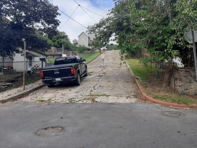
The tough part of the climb is the Westernport Wall. A section of crumbling pavement that hits up to 25% and is closed to vehicular traffic. This section is on the Savageman Tri race, and completing the hill on your pedals earns you a brick in the roadway.
ROUTE MAP
PROFILE TOOL
Route Data
S.G. (%)
hide
Segment Data
hide

Climb Profile Not Found
CLIMB SUMMARY

Cycling Rock Street

Ride 1.1 miles gaining 663’ at 11.7% average grade.

Climb start

Climb summary by PJAMM ambassador Dan Razum.

The climb starts in a residential neighborhood at the junction with Rte 36. We are riding on what is basically the main entrance to the neighborhood on this side of Rte 36 so there are a few cars but  it's not a problem because we are on city streets and speeds are low.

The climbing starts out steep right from the beginning, with houses on either side.  At the steepest section the road is closed to car traffic for one block and this is accomplished by a barrier at the top of the section.  The barrier is such that you cannot ride around it, you have to dismount the bike and walk around it.  This means that after you climb the steepest section, you have to stop and get off your bike before continuing, which maybe is not a bad thing…

In the closed off steep section there are bricks in the roadway with the names of people who conquered this  climb in a local race called Savageman.  The bricks also show the year.  The latest bricks we saw were from 2019 so they probably discontinued the race during the pandemic.  We would imagine that when they had the race the barrier at the top was probably removed because otherwise it would suck to have to stop and get off your bike in the middle of a race!

After the bricks the road continues climbing, a little less steep perhaps, but still a serious gradient. Since we are now out of town there is little traffic.  We wind up the side of the mountain, past a water tank and finally we reach the top, where two big trees indicate that we've arrived.  There are nice views of the mountains beyond and we can appreciate the steepness below.

A little ways beyond the top there is a road to the left which appears to be a way down the mountain but unfortunately it is a private road from a coal company and it turns to dirt halfway down. So the best way  to descent is back the way we came up.

Finish