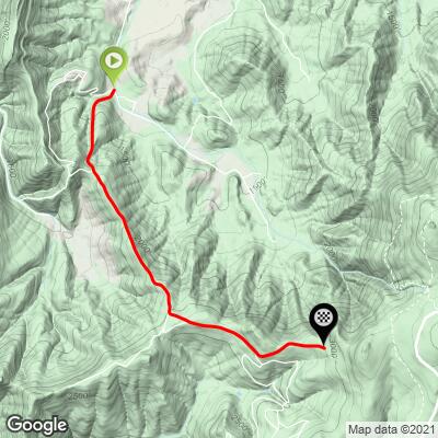
12.7
PDI
3.7 mi
DISTANCE
1,727 ft
GAINED
8.7 %
AVG. GRADE
FULL CLIMB STATS
INTRO
PLAN YOUR ROUTE
8.3% average grade (9.5% climb only). The gradient varies significantly throughout the climb - 11% is descent, 17% of the climb is at 0-5%, 30% is at 5-10%, 31% is at 10-15%, and 11% is at 15-20% grade. The steepest quarter-mile is 17.5%.
Use the “Routes in Area” button on the menu bar to see other bike climbs in this area.
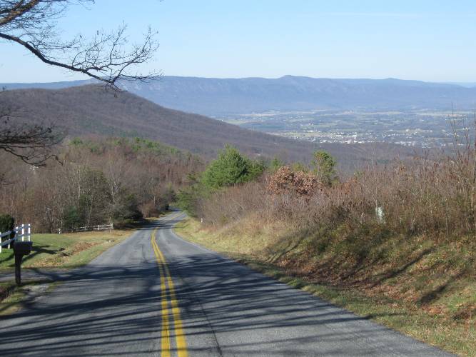
Roadway: Two lane road with no shoulder in good condition - the last 1.4 miles are on a gravel road.
Traffic: Mild.
Parking: On Pine Grove Road just across from the start of the climb - Map; Street View.
Provisions: None along the ride. Closest food and beverages are in Stanley, three miles north - Map.
Before heading out on any cycling adventure check out our Things to Bring on a Cycling Trip and use our interactive check list to ensure you don't forget anything.
This route ends at a gate with a sign that says no bicycles on the gravel path beyond - here is input from a friend from Virginia regarding the segment beyond the gate (about two miles to Blue Ridge Parkway) - "it is manageable on a road bike but we’re not supposed to get caught riding past the gate. Per the sign, you can walk your bike beyond that point, but not ride. Last time we were there we walked the bikes and I’m glad we did so because we were passed by a park ranger vehicle and technically they’re allowed to seize your bike if caught riding it. It wasn’t a terrible walk."
ROUTE MAP
MEMBER RATING
CURRENT WEATHER
PJAMM TRIPS ADVENTURE STARTER BUNDLES
Check out PJAMM Adventure's prepackaged (self-guided) cycling trips. They will help you plan, document and conquer your next adventure.
NEARBY CLIMBS (0) RADIAL PROXIMITY
FROM No Climbs Found
MEMBER REVIEWS & COMMENTS
Let us know what you thought of this climb. Signup for our FREE membership to write a review or post a comment.
Already have an account?
LOG IN HERE
Mango
I live about 10 miles from this road and try to ride it at least once a year. I'm 70 now & wondered if I'd have the juice, but a few days ago I did make it to Skyline Drive--not without a lot of snaking back & forth across the road, though. The dirt section beyond the gate was a pain--not as steep as the pavement, but badly wash boarded and difficult to keep momentum.
Mmatt

The severity of this climb is in the extended sections of road at 12-18% gradient. But the nice thing is there are short breaks on the climb with flatter sections and even a short downhill. Gorgeous views and very minimal traffic. Extend the climb up to Skyline by climbing the gravel road at the end. When I climbed this there was one car that came down the gravel road and an ambulance that went up! Very rideable on a road bike as it's a well maintained and lightly travelled gravel road. This allows you to make a nice loop from Luray or Sperryville.
jsummers
Be ready early on this one as the initial half mile is severe. From there it goes up and down but is solid overall, ending at a dead end. The descent is vicious as well, particularly the very end, just watch it as you spill out onto another road at the bottom.