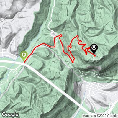
Cumberland Gap Bike Climb - PJAMM Cycling

2.2
FIETS
3.1 mi
DISTANCE
1,070 ft
GAINED
6.6 %
AVG. GRADE

FULL CLIMB STATS

Page Contributor(s): Dan Razum, San Jose, California

INTRO

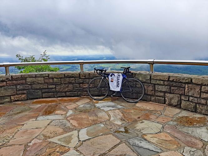
"Historic Cumberland Gap is a gem of an ascent near the TN border in southeast KY.  An easy start leads riders under Route 25E.  Once past you enter thick and scenic woods and soon the grade eases.  After passing the road to Sugar Run (keep straight) the route turns into a classic mountain climb.  Straight stretches in this section are linked together by tight switchbacks, many of which contain double digit grade.  A final switchback leads to decreased grade and the climb finishes at a parking area." (This quote is presented with the approval of John Summerson, from his book, The Complete Guide to Climbing (by Bike), 2nd Edition, pg. 108.)

See more details and tools regarding this climb's grade via our interactive Profile Tool.
Information Not Available

If you have any information regarding this climb, we'd like to hear from you. Click the CONTRIBUTE button to share your thoughts with us.

Information Not Available

If you have any information regarding this climb, we'd like to hear from you. Click the CONTRIBUTE button to share your thoughts with us.

Before heading out on any cycling adventure check out our Things to Bring on a Cycling Trip and use our interactive check list to ensure you don't forget anything.
Information Not Available

If you have any information regarding this climb, we'd like to hear from you. Click the CONTRIBUTE button to share your thoughts with us.

ROUTE MAP

MEMBER RATING

Difficulty: Challenging
5
Road
4
Traffic
4
Scenery

CURRENT WEATHER

PJAMM TRIPS ADVENTURE STARTER BUNDLES

Check out PJAMM Adventure's prepackaged (self-guided) cycling trips. They will help you plan, document and conquer your next adventure.
ALL TRIPS
Browse all of our prepackaged trips and find your next adventure!
Smoky Mountain National Park
United States (NC,TN)
17 ROUTES
31 POIs
ROUTE STATS (TOTAL)
181.8
mi
DISTANCE
34,253
ft
ELEV. GAIN
The Blue Ridge Parkway (North)
United States (NC,TN,VA)
38 ROUTES
70 POIs
ROUTE STATS (TOTAL)
716.5
mi
DISTANCE
75,697
ft
ELEV. GAIN
The Blue Ridge Parkway (South)
United States (NC,TN,VA)
30 ROUTES
63 POIs
ROUTE STATS (TOTAL)
690.7
mi
DISTANCE
74,180
ft
ELEV. GAIN

NEARBY CLIMBS (0) RADIAL PROXIMITY

FROM
No Climbs Found

MEMBER REVIEWS & COMMENTS

Let us know what you thought of this climb. Signup for our FREE membership to write a review or post a comment.
Already have an account?

Nov 6, 2021
difficulty: Challenging
scenery: 4
traffic: 4
road: 5
Nov 6, 2021
scenery: 4
traffic: 4
road: 5
Not an alarmingly steep climb at any point so it’s not that hard to summit as long as you don’t just attack it. Parking is available at the top and bottom and the view is spectacular.
ROUTE MAP
PROFILE TOOL
Route Data
S.G. (%)
hide
Segment Data
hide

Climb Profile Not Found
CLIMB SUMMARY

Cycling Cumberland Gap

Ride 3.2 miles gaining 1,232’ at 7.3% average grade.

Climb summary by PJAMM ambassador Dan Razum, San Jose, California.

This is a nice climb in the Cumberland Gap National Historical Park, with great views at the top. There is a large parking area at the Visitors Center near the base of the climb and it is probably best to start the climb there.  If you come from Middlesboro it is possible to bike to the climb, which would include about a quarter of a mile riding on Route 25E, which is a very busy 4 lane highway with lots of traffic.  From the east it is not possible to bike to the climb because you cannot bike through the Cumberland Gap Tunnel on Rte 25E.

From the Visitors Center parking lot (there is no entrance fee to the park) it is about a quarter mile to the base of the climb, a short little warm up. We ride through a thick forest the entire way.  There are some steep sections and several switchback curves, all which keep the ride varied and interesting.  Partway up there is a nice view towards the west,  which is worth checking out because the overlook view at the top does not show this direction.

When we reach the top there is another large parking lot, but there aren't any views from the parking lot.  On the left side there is a pavilion with restrooms and a trail going to the Pinnacle Overlook but there are stairs on the trail.  If we ride around the parking lot there is another path to the overlook with no stairs and we can ride this path 600 ft to the overlook.  From the overlook there are sweeping views of the tri-state area. It is worth doing the climb just for the views at the overlook.