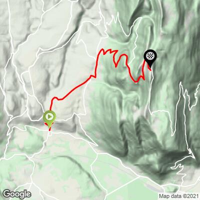
Col du Grand Colombier (Artemare) Bike Climb - PJAMM Cycling

10.3
FIETS
9.6 mi
DISTANCE
4,031 ft
GAINED
8 %
AVG. GRADE

FULL CLIMB STATS

INTRO

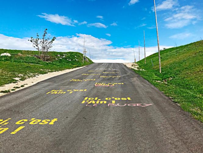
This mountain range is home to some of the most difficult bike climbs in Europe outside of the Pyrenees and Alps. Little known in the U.S., this mountain range is poised to burst onto the climbing scene, if it has not already done so. Col du Grand Colombier initially became well known to cyclists via the Tour de l'Ain (late season professional cycling race held generally in eastern France). From what we can tell from our research, Col du Colombiere has been included in the Tour de France first in 2012 (stage 10) and again 2016 (stage 15).

See more details and tools regarding this climb's grade via our interactive Profile Tool.
Information Not Available

If you have any information regarding this climb, we'd like to hear from you. Click the CONTRIBUTE button to share your thoughts with us.

Information Not Available

If you have any information regarding this climb, we'd like to hear from you. Click the CONTRIBUTE button to share your thoughts with us.

Before heading out on any cycling adventure check out our Things to Bring on a Cycling Trip and use our interactive check list to ensure you don't forget anything.
Information Not Available

If you have any information regarding this climb, we'd like to hear from you. Click the CONTRIBUTE button to share your thoughts with us.

ROUTE MAP

MEMBER RATING

Not Yet Rated
-
Road
-
Traffic
-
Scenery

CURRENT WEATHER

PJAMM TRIPS ADVENTURE STARTER BUNDLES

Check out PJAMM Adventure's prepackaged (self-guided) cycling trips. They will help you plan, document and conquer your next adventure.
ALL TRIPS
Browse all of our prepackaged trips and find your next adventure!

NEARBY CLIMBS (0) RADIAL PROXIMITY

FROM
No Climbs Found

MEMBER REVIEWS & COMMENTS

Let us know what you thought of this climb. Signup for our FREE membership to write a review or post a comment.
Already have an account?
ROUTE MAP
PROFILE TOOL
Route Data
S.G. (%)
hide
Segment Data
hide

Climb Profile Not Found
CLIMB SUMMARY

Cycling Col du Colombier from Artermare

Climb 15.4 kilometers (9.6 miles)  gaining 1,237 meters (4,057’) at 8.1% average grade.

The Jura mountain range is home to some of the most difficult bike climbs in Europe outside of the Pyrenees and Alps.  Little known in the U.S., this mountain range is poised to burst onto the climbing scene, if it has not already done so. Col du Grand Colombier initially became well known to cyclists via the Tour de l'Ain (late season professional cycling race held generally in eastern France).  Col du Colombier has been featured in the Tour de France in 2012 (stage 10), 2016 (stage 15), 2017 (stage 9) and 2020 (stage 15 mountaintop finish; won by Tadej Pogacar, sitting at #2 after this stage).  

The official 2020 Tour de France website writes of Col de Colombier:

“Grand Colombier, a gruelling climb from the Jura that overlooks the Mont Blanc, the Alps, the Bourget lake and the Rhône valley, is a regular inclusion on the map of the Tour de France since 2012. That year, Thomas Voeckler was first at the top before winning the stage at Bellegarde-sur-Valserine. Rafal Majka and Warren Barguil crested it first in 2016 and 2017 respectively. Different versions of the Grand Colombier stage have been experimented with a finish closer to the climb or the climb to be done twice but this is the first time with a Tour de France finish at the top.”  letour.fr

In 2018 we climbed all 4 routes to the Col du Colombiere and felt this was the most difficult of them all. Our subjective opinion is supported by statistics with the approach from Colombiere rating higher on the Fiets Index than the other 3 routes to the top.

There are brutally steep segments on this climb:  ½ kilometer at 16.2% (beginning km 10), 1 kilometer averages 15.3% (also beginning at km 10) and there is a full 2 kilometers averaging a torturous 14% (km 9.1 - 11.1).

The climb begins in the quaint village of Artemare (“Upper Sea”; population 1,237 in 2017).

Climb begins in Artemare, Auvergne-Rhône-Alpes.

Surrounded by wheat fields along much of the first half of the ride

Col sign at Virieu-Le Petit (tiny town of 297 inhabitants).

Views along the climb.

Kilometer markers are placed along the route.

This magnificent col is located in the Jura Mountains:

“The Jura Mountains . . .  French: Massif du Jura, (German: Juragebirge, Italian: Massiccio del Giura) are a sub-alpine mountain range located north of the Western Alps, mainly following the course of the France–Switzerland border. The Jura separates the Rhine and Rhône basins, forming part of the watershed of each.

The name "Jura" is derived from juria, a Latinized form of a Celtic stem jor- "forest". The mountain range gives its name to the French department of Jura, the Swiss Canton of Jura, the Jurassic period of the geologic timescale, and the Montes Jura of the Moon.”  
Wikipedia 

The Jura mountain range runs in an arc along the eastern edge of central France and the western edge of Switzerland.  To orient ourselves very generally, using Lake Geneva as a reference point, the mountain range starts in France to the southwest of Lake Geneva and arcs above Lake Geneva, ending to the northeast of it.  Here is a crude PJAMMCycling effort at marking the mountain range:


Access to full Climb Summary requires a PJAMM Cycling PRO Membership!

It takes less than a minute to sign up & with your PRO membership you can:
  • Rate climbs, post comments and share your experiences on any of our climb pages
  • Create bucket lists of climbs & mark the dates you complete them
  • Weather data for all climbs - Start & Finish
  • Upload photos to your member page to customize your PJAMM Cycling experience
  • Utilize all of our interactive tools - Profile & Routes in Area
  • Download climb route .gpx files
LEARN MORE
SIGN UP

Already have an account? LOG IN HERE