
34.5
PDI
16.7 mi
DISTANCE
5,709 ft
GAINED
6.1 %
AVG. GRADE
FULL CLIMB STATS
Page Contributor(s): Ard Oostra, Montreux, Switzerland
INTRO
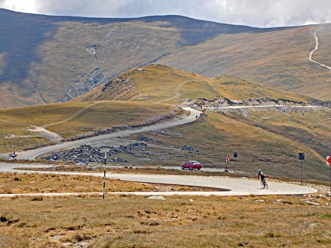
Transalpina South climbs 16.7 miles and 5,709 feet from Novaci, in Romania's Gorj County, to the high alpine plateau below Păpușa Peak at 6,928 feet (2,111 m) on DN67C - the highest paved road in the country. The average grade is 6.1%, but this is the steeper of Transalpina's two approaches: the steepest quarter-mile hits nearly 19% grade, and the steepest 100 yards spikes to 22.4%, noticeably harder than what riders find climbing the same pass from the north.
Transalpina carries the nickname Drumul Regelui, the King's Road - Romanian troops carved the modern route between 1934 and 1939 under King Carol II as a strategic military road connecting Wallachia and Transylvania across the Parâng Mountains, replacing an older track once known as Poteca Dracului, the Devil's Path. The road wasn't fully paved until 2009, and it still closes every winter under snow.
About two-thirds of the way up, the road passes through Rânca, a mountain resort at 1,600 meters with hotels, restaurants, and its own small ski area - a natural rest stop before the final push onto the wide-open high plateau near Păpușa, Urdele Pass, and Gâlcescu Lake. The road reopens seasonally each year (May 29 through a tentative November 1), with a posted 30 km/h speed limit and overnight closures once it's open, so check current conditions before you go.
PLAN YOUR ROUTE
 We've partnered with Sherpa-Map.com to bring you the best route planning tool. With a PRO Membership you can use this climb as a reference when creating your route.
 Transalpina South averages 6.1% over 16.7 miles, gaining 5,709 feet from Novaci (1,546 ft) to 6,928 feet near Păpușa. It's a genuinely uneven climb - the steepest mile averages 10.0%, the steepest half-mile 13.6%, and the steepest quarter-mile 18.7%, with a brief 100-yard ramp hitting 22.4%. Climbing this direction, from Novaci, is meaningfully steeper than the approach from the north side of the pass, so pace the lower slopes conservatively.
Roadway: The DN67C is paved the entire way from Novaci to the high plateau near Păpușa, and has been fully paved since 2009. The road closes every winter under snow and reopened for the 2026 season on May 29, with a posted 30 km/h speed limit and a weight restriction for large vehicles; overnight closures apply once it's open (9 p.m. to 7 a.m. as of July 2026), with a tentative closing date of November 1. Check CNAIR's current status before a late-season visit, since fog, heavy rain, and early snow can trigger temporary closures even within the open season.
Traffic: Traffic is light to moderate for most of the year, picking up on summer weekends and during Rânca's peak season, when day-trippers and motorcyclists use the road for the scenery. It thins out considerably above Rânca toward the high plateau.
Parking: Novaci is a small town with informal free parking near the town center and along DN67C at the southern edge of town, where the climb effectively begins. Riders looking for a shorter effort can also start partway up at Rânca, which has its own parking near the resort's hotels and ski lifts.
Bring low gearing - the steepest quarter-mile hits 18.7% and there's a 100-yard ramp at 22.4%, both well above the 6.1% average. The high plateau near the finish sits above 2,100 meters (6,900 ft), so weather can turn quickly even in summer; pack a wind layer and check the forecast before committing to the full distance. Rânca, about two-thirds of the way up, is the last reliable spot for food and water before the exposed upper section.
Before heading out on any cycling adventure check out our Things to Bring on a Cycling Trip and use our interactive check list to ensure you don't forget anything.
Novaci is a small Gorj County town at the southern foot of the Parâng Mountains, with basic guesthouses and restaurants for a pre-ride night. Many riders base higher up in Rânca instead - a real mountain resort with a wider choice of hotels, pensions, and restaurants (Complex Veverita and Pensiunea Constantin among them), plus its own small ski area in winter. Once past Rânca, the road opens onto the high plateau near Urdele Pass and Gâlcescu Lake, both worth a stop if you have the legs left.
Transalpina North, the gentler approach to the same pass from Obârşia Lotrului, is the natural pairing if you want to ride both sides of Romania's highest road in one trip. Check conditions at the top before you commit to the full climb with our Weather tool.
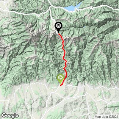
ROUTE MAP
MEMBER RATING
CURRENT WEATHER
PJAMM TRIPS ADVENTURE STARTER BUNDLES
Check out PJAMM Adventure's prepackaged (self-guided) cycling trips. They will help you plan, document and conquer your next adventure.
NEARBY CLIMBS (0) RADIAL PROXIMITY
FROM No Climbs Found
MEMBER REVIEWS & COMMENTS
Let us know what you thought of this climb. Signup for our FREE membership to write a review or post a comment.
Already have an account?
LOG IN HERE
SKCBT
Avoid riding in mid July! Temperatures can reach +40C!
