Cycling the GREAT Dun Fell, England
Ride 7.5 kilometers gaining 625 meters at 8.4% average grade.
![]()
This unique road bike climb is both the second hardest in the UK and the highest paved road in England. The climb takes us from 714 meters, to the radar dome 848 meters (2,782’) above sea level in just 7.5 kilometers! The road ends at an Air Traffic Control facility that services Northern England and Southern Scotland.

Climb begins at the Knock Creek Christian Center on an unnamed road north of Knock. Whether these old stone houses are still lived in, I could not tell. I saw no sign of life on the day that I rode through, but they seem to be in relatively good condition.

You’ll have the road to yourself, almost guaranteed. The road is technically off limits to motor vehicles (and maybe cyclists too - but it’s good to have plausible deniability). I was alone on the pristine road for the entirety of my climb on the day that I rode in early July 2022. Actually, you’re never truly alone in England. The sheep are ever-present and always skittish.

Gate and surrounding area at mile 1.8.

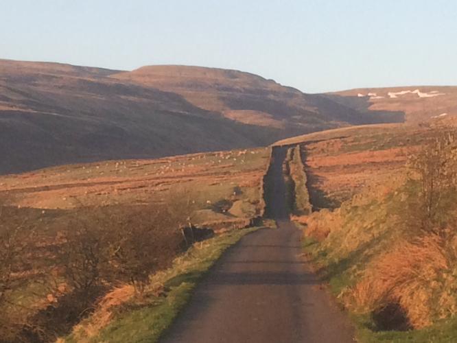
Too many epic viewpoints along this magnificent climb to count.

As I made my way onto the upper slopes of the mountain, imposing clouds began forming and the winds really began howling from my starboard side. I had difficulty riding in a straight line as the gusts came through.

Gate at mile 3.9.
As the ancient saying goes:
If you’re not hopping a fence or scurrying under a gate, then you’re not trying hard enough!

Scree field on our left at mile three. The grade pitches up well into the double digits as the road traces the fast river up to a saddle point of the mountain. One hopes that the summit is in view at this point, but don’t be fooled. The Great Dun Fell is not done yet…

Cow Green Reservoir to the right as seen towards the top of the climb.

End of the steepest quarter-mile at 15.8%.

As the road wraps behind the mountain the winds became gale force -- some of the strongest winds that I have ever experienced. I could easily lean into the wind without falling down (with a belly full of bacon, sausage, and haggis of course).

The end of the road is on the true summit of the mountain and marked by a Radar Station. On a clear day you’ll have some of the best views available of the North Pennine. As the road is closed to motor-vehicles, this is one of the most fun descents in all of England. There are no potholes to contend with, but watch out for those sheep!
PJAMM Cycling’s Brad Butterfield writes after a 2022 summit of the mountain:
Over its steep 4.6 miles of mountain road which take you to a Radar Station, The Great Dun Fell earns its place as the most difficult climb in the United kingdom. This golfball-looking radar station is visible from the lower slopes of the mountain and gives a tough visual of how much more vertical feet of gain there is to be climbed before the summit. The road is in pristine condition throughout the climb. There are signs suggesting the road is private and not to cycle on it, but I had no issues. Not a single car, cyclist, or hiker was out on the road with me on the day that I rode in early July. The Great Dun Fell reaches the summit of the second highest mountain in the Pennines at 2,782 feet above sea level. Views of the surrounding farmlands to the south and the barren lands north are very impressive from the summit point. The Great Dun Fell is one climb every cyclist needs to check off of their UK climbing list. A must-do if there ever was one. Prepare for high winds and cold temps at the summit. I had thermal gear and was glad that I did!
The climb is on the western edge of North Pennines Area of Outstanding Natural Beauty:
“The North Pennines was designated as an Area of Outstanding Natural Beauty (AONB) in 1988 for its moorland scenery, the product of centuries of farming and lead-mining. At almost 770 square miles (2,000 km2) it is the second largest of the 49 AONBs in the United Kingdom. The landscape of the North Pennines AONB is one of open heather moors between deep dales, upland rivers, hay meadows and stone-built villages, some of which contain the legacies of a mining and industrial past. The area has previously been mined and quarried for minerals such as barytes, coal fluorspar, iron, lead, witherite and zinc.In 2013, a Canadian mining company were allowed to test drill for zinc around Allenheads and Nenthead. They said the region was sitting on a "world-class" deposit of zinc and predicted that a new mine in the area could produce 1,000,000 tonnes (980,000 long tons; 1,100,000 short tons) of zinc ore per year” (Wikipedia - North Pennines).
The climb also borders and runs parallel to the southwestern border of North Pennines Area of Outstanding Natural Beauty:
“The North Pennines was designated as an Area of Outstanding Natural Beauty (AONB) in 1988 for its moorland scenery, the product of centuries of farming and lead-mining. At almost 770 square miles (2,000 km2) it is the second largest of the 49 AONBs in the United Kingdom. The landscape of the North Pennines AONB is one of open heather moors between deep dales, upland rivers, hay meadows and stone-built villages, some of which contain the legacies of a mining and industrial past. The area has previously been mined and quarried for minerals such as barytes, coal fluorspar, iron, lead, witherite and zinc.In 2013, a Canadian mining company were allowed to test drill for zinc around Allenheads and Nenthead. They said the region was sitting on a "world-class" deposit of zinc and predicted that a new mine in the area could produce 1,000,000 tonnes (980,000 long tons; 1,100,000 short tons) of zinc ore per year” (Wikipedia - North Pennines)

Thank you Andrew Hartley of Manchester, England.
The roadway is not open to motor vehicles but thankfully is to walkers, cyclists, and horseriders.

Charlie Thackeray (of Essex, UK) Everested the Great Dun Fell July 22-23
Read about Charlie’s Everest at Thoughts on Everesting.
![]()
My Strava comment along with the comment from the founder of Everesting.
The Great Dun Fell climb is considered by Simon Warren (Another Greatest Cycling Climbs, 2012) to be the hardest hill climb in the UK.
Cycling Uphill has a nice summary of this climb by Tejvan (May 6, 2014):
“Another 100 climbs states that Great Dun Fell is the greatest climb in England’ “Our Mont Ventoux’ it has no peers, there is no comparison.” The only surprising thing is that I hadn’t heard of the climb until quite recently. But, since finding out there was a Pyrannean style climb in England, it was definitely on my list of things to do. Since I was up in Kendal for Shap Fell hill climb, I thought it would be good to combine the two.
I’ve spent many years scouring OS maps, looking for the most difficult climbs, but you could quickly scan over Great Dun Fell (on OS 91), assuming it is nothing more than a farmyard track or glorified footpath. Ironically it has a pretty good road surface all the way to the top. The top half is closed to cars, but open to bicycles. It is definitely worth a visit and is a real epic climb.” Read more
![]()