12.8
PDI
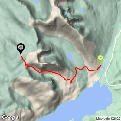
5.1 mi
DISTANCE
1,993 ft
GAINED
7.5 %
AVG. GRADE
FULL CLIMB STATS
Page Contributor(s): Heiko Linnert, Amberg, Germany
INTRO
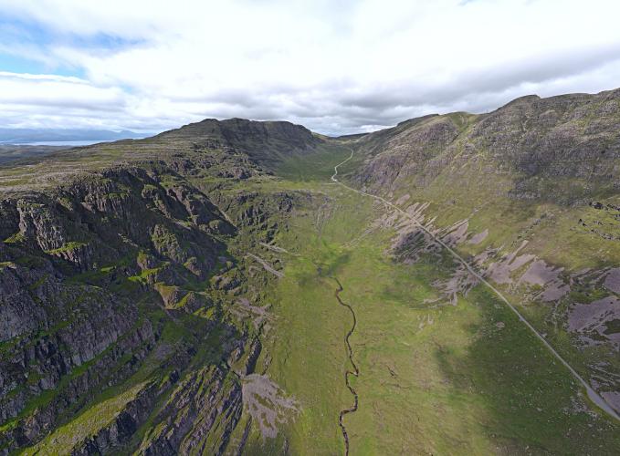
Simon Warren was kind enough to provide us his Top 10 Hardest and Top 10 Most Epic climbs of England, Wales, Scotland and the UK combined. Simon ranks Bealach na Ba as the most epic bike climb in Scotland and the entire United Kingdom - "This is it: The Holy Grail, the toughest and wildest climb in Britain. Anything you have read or been told about this amazing road is likely to be true. For once, you can believe the hype.” (Simon Warren, 100 Greatest Cycling Climbs, A Road Cyclist's Guide to Britain's Hills, p. 121).
Both sides of the pass rank #1 and 2 Scotland and #4 and 5 UK - Bealach na Ba - Both Sides.
Visit our Top UK and also our Top Scottish hill climbs pages for photos, summaries and statistics for their respective top hill climbs. For the Top 10 Most Epic climbs, visit our Scotland Most Epic and our UK Most Epic pages.
PLAN YOUR ROUTE
The average grade of this great climb is 6.8% and the crux of this climb is from kilometer 4 to 8.5 averaging 9.6%. 56% (5.2 km) of the climb is at 5-10% and 16% (1.5 km) 10-15%. The steepest 500 meters is 14% and there is a continuous kilometer at 13%.
See more details and tools regarding this climb's grade via the “Profile Tool” button above.
Roadway: Fully paved and in good condition. The road is very narrow 2 lanes with no center stripe of shoulder although the climb is safe for a cyclist.
Traffic: Mild.
Parking: Climb start - Map; Street View.
Provisions: There are no provisions along this climb.
Gear and Weather: This is Northern Scotland and it is very wet here, averaging 1876 mm (74 inches) per year. Consult the PJAMM "Full Forecast" feature for the time you expect to be riding this climb.
Before heading out on any cycling adventure check out our Things to Bring on a Cycling Trip and use our interactive check list to ensure you don't forget anything.
Consider this climb as an out and back from either side of the summit, taking on Bealach na Ba (Applecross) at 35 kilometers (22 miles) gaining 1,262 meters (4,141'). See map.
If you'd like to stay in the area, there are some historic hotels and inns, along with very lovely cottage rentals as well.
ROUTE MAP
MEMBER RATING
CURRENT WEATHER
PJAMM TRIPS ADVENTURE STARTER BUNDLES
Check out PJAMM Adventure's prepackaged (self-guided) cycling trips. They will help you plan, document and conquer your next adventure.
NEARBY CLIMBS (0) RADIAL PROXIMITY
FROM No Climbs Found
MEMBER REVIEWS & COMMENTS
Let us know what you thought of this climb. Signup for our FREE membership to write a review or post a comment.
Already have an account?
LOG IN HERE


