
21.7
PDI
9.3 mi
DISTANCE
3,441 ft
GAINED
7.1 %
AVG. GRADE
FULL CLIMB STATS
INTRO
PLAN YOUR ROUTE
 We've partnered with Sherpa-Map.com to bring you the best route planning tool. With a PRO Membership you can use this climb as a reference when creating your route.
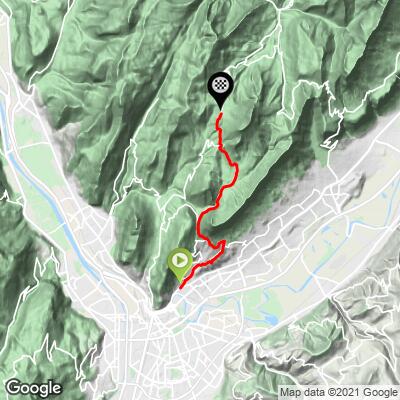
 Col de Porte gains 1,048.8 m (3,441 ft) in 14.9 km (9.3 mi), a 7.1% average, from 246.6 m (809 ft) in La Tronche to 1,295.4 m (4,250 ft) at the top of our route, just below the 1,326 m (4,350 ft) pass sign.
The steepest 10 km average 7.1%, the steepest 5 km 8.3%, the steepest 2 km 8.9% and the steepest 500 m 9.2%. The steepest 91 m (100 yd) reach 9.7%.
The first kilometers run through La Tronche and Corenc, and riders and guides agree the toughest stretch is the early climb to the Col de Vence at about 6.6 km (4.1 mi). After that the grade moderates through the Sappey-en-Chartreuse area to the Col de Palaquit at about 12.5 km (7.8 mi), then through forest to the pass.
Roadway: Paved the entire way on the D512, the Route de Chartreuse. Two recent projects are worth knowing about: La Tronche renovated the road, added sidewalks and traffic-calming features between May and November 2024, and in 2025 the retaining wall at the Corne d'Or hairpin in Corenc was reinforced, with a full road closure from June 30 to August 30 that year. Check Grenoble-Alpes Métropole's road-works notices before you ride.
Traffic: Heavy at the bottom. The first kilometers through La Tronche and Corenc carry commuter and local traffic, and it thins once you are out of town. The D512 is the main road between Grenoble and Saint-Pierre-de-Chartreuse, so it gets busier on weekends. Early starts on weekdays are the quietest.
Parking: There is no dedicated cyclist parking at the start. La Tronche is a dense residential suburb directly beside Grenoble, so most riders simply ride out from wherever they are staying in the city, or use street parking in the neighborhood near the town hall, where the climb begins.
Gear: A compact chainring is plenty here. Bring lights if you plan to combine the col with the rest of the Chartreuse Trilogy, since it makes a long day.
Provisions: Carry enough water for the whole climb and top up in Le Sappey-en-Chartreuse, the village you pass through around two-thirds of the way up.
Before heading out on any cycling adventure check out our Things to Bring on a Cycling Trip and use our interactive check list to ensure you don't forget anything.
The start is by La Tronche's town hall, and the local club, La Tronche Vélo Sport, has organized a mass-start timed ascent of the col from here (the 2021 edition ran on September 5, and its route ran 15 km from La Tronche to the pass). If you are up for more, the classic Chartreuse Trilogy loop from La Tronche links Col de Porte, Col du Cucheron and Col du Granier in about 115 km (71.5 mi) with roughly 2,300 m (7,546 ft) of climbing.
Le Sappey-en-Chartreuse sits at 1,014 m (3,327 ft), about 13 km (8.1 mi) from Grenoble. It has restaurants and shops, and its church has stained glass by the artist Arcabas. In winter the Col de Porte area is a Nordic ski and biathlon venue known for reliable snow. For the route up the back way through Sarcenas, see our Col de Porte (Route de Clémencières) page. Conditions at 1,300 m can differ from Grenoble, so check the forecast at the col with our Weather tool before you go.
ROUTE MAP
MEMBER RATING
CURRENT WEATHER
PJAMM TRIPS ADVENTURE STARTER BUNDLES
Check out PJAMM Adventure's prepackaged (self-guided) cycling trips. They will help you plan, document and conquer your next adventure.
NEARBY CLIMBS (0) RADIAL PROXIMITY
FROM No Climbs Found
MEMBER REVIEWS & COMMENTS
Let us know what you thought of this climb. Signup for our FREE membership to write a review or post a comment.
Already have an account?
LOG IN HERE
