INTRO
PLAN YOUR ROUTE
 We've partnered with Sherpa-Map.com to bring you the best route planning tool. With a PRO Membership you can use this climb as a reference when creating your route.
 ROUTE MAP


 We've partnered with Sherpa-Map.com to bring you the best route planning tool. With a PRO Membership you can use this climb as a reference when creating your route.
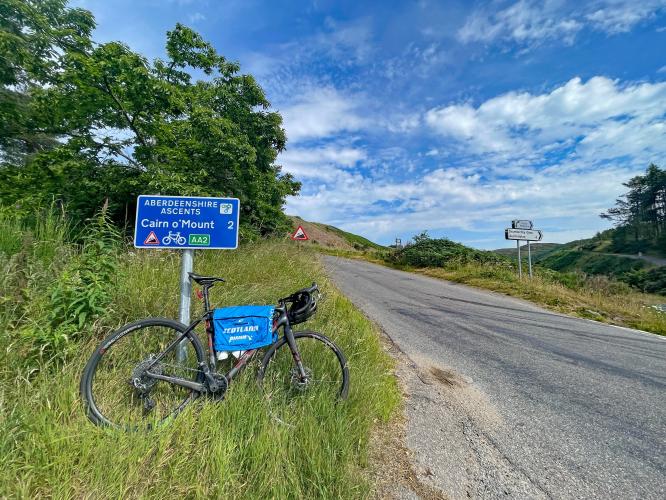
Cycling Cairn O’Mount, Scotland
Ride 2.1 miles gaining 1,038’ at 9.5% average grade (second steepest Scottish climb).
This is a very difficult yet fun climb and is the fifth hardest bike climb in Scotland due primarily to its steep gradient. Its name derives from the ancient cairn located at the summit of the hill.
Just south of the Cairngorm National Park lies the winding narrow road of Cairn O’ Mount. It is immediately clear that this is a cycling destination as there are a number of encouraging spray-paintings written on the road for cyclists. My favorite was one near the summit on a brutally steep corner that simply read “Oh me.” In addition to fellow cyclists, you’ll be sure to see motorcycle tourers and sightseers, making the narrow mountain road pretty hectic on a sunny day. The summit point is marked by an underwhelming “End of Route” signpost. I parked at the base of the climb in the tearoom parking lot and didn’t have an issue.
Climb begins by riding up Old Military Road from Clattering Bridge Restaurant (B974).
Clattering Bridge gets a 4.7 Google Rating on 369 reviews as of November 2022.
The name “Old Military Road” originates from General Wade's Military Roads which were a network on military-serving roads constructed by the British Government to address conflict beginning with the Jacobite rebellion of 1715. This particular military road was a major route from Fettercairn and was maintained by the military from 1761 to 1784 (Wikipedia - Military Roads of Scotland).
The remains of an old stone Scottish cottage are on the left one-half mile from the start.
Plenty of sweeping views along the climb.
Agree 100%!
No question where the climb ends.
The climb ends near a hiking pass to our left and Cairn O’Mount, which is the high point in the area at 455 meters (1,493’). Before the road softens a bit over the last 100 yards, there is a 500-yard segment averaging 13% which is the steepest segment of the entire climb.
Cairn at the summit of the climb which dates back to 2000 BC.
That’s a wrap!
But, a little more of possible interest - This climb is located in Cairngorms National Park in north east Scotland and is the largest park in the British Isles (Wikipedia - Cairngorms National Park).
“Cairn O' Mounth/Cairn O' Mount (Scottish Gaelic: Càrn Mhon) is a high mountain pass in Aberdeenshire, Scotland. The place name is a survival of the ancient name for what are now the Grampian Mountains, earlier called "the Mounth" (in Gaelic: "monadh", meaning mountains). The name change happened from circa 1520 AD. The Ordnance Survey shows the name as Cairn o' Mount.
It has served as an ancient military route at least from Roman times through the 13th century AD. The alignment of the Cairnamounth, Elsick Mounth and Causey Mounth ancient trackways had a strong influence on the medieval siting of many fortifications and other settlements in the area comprised by present-day Aberdeenshire on both sides of the River Dee.
Cairn O' Mounth is at 1493 feet (454 m) above mean sea level,[4] and there are various commanding views of the surrounding landscape which extend as far as the North Sea.
Before the modern A90 road was constructed, the pass served as one of the eight major crossing points for those travelling over the Grampians to Deeside and into Northern Scotland; this entire crossing trackway is historically known as the Cairnamounth. Deriving from this theory, a small village grew up in the pass. The high granite tor of Clachnaben overlooks the road (now called the B974 road) through the pass. The Scottish Tourist Board describes the modern B974 as an "adventurous" road, and it is often impassable due to snow or flooding in winter. In the summer fatalities are commonly reported in the press.
In the 11th century AD, Mac Bethad (commonly known as Macbeth) survived the original English invasion, for he was defeated and mortally wounded or killed by Máel Coluim mac Donnchada on the north side of the Mounth in 1057, after retreating with his men over the Cairnamounth Pass to take his last stand at the battle at Lumphanan.[2] The Prophecy of Berchán has it that he was wounded and died at Scone, sixty miles to the south, some days later.[5] Mac Bethad's stepson Lulach mac Gille Coemgáin was installed as king soon after.
The Cairn O'Mounth pass was used by Edward I's English army in 1296 AD, en route back to England. It was also used twice by Viscount Dundee's army during the first Jacobite rising of 1689. The route over the pass is probably prehistoric: there is a cairn in the pass that has been dated to approximately 2000 BC. It is possible that this cairn is the one named in the name of Cairn O'Mounth, “(Wikipedia - Cairn O’Mounth).