![]()
Cycling The Cairnwell, Aberdeenshire, Scotland.
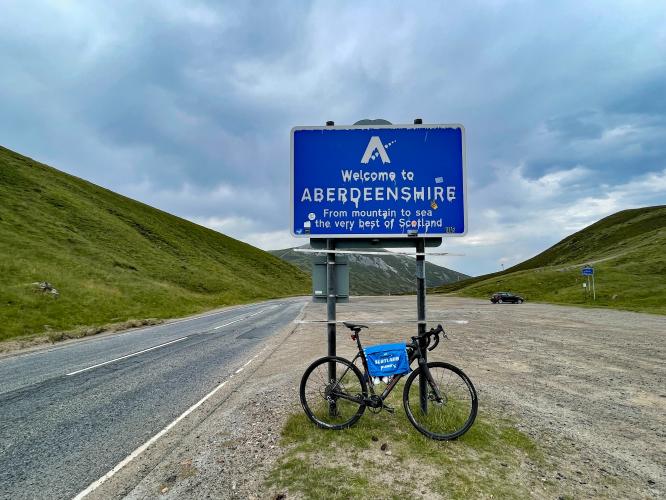
Climb Finish.
The Cairnwell is named after “The Cairnwell” mountain peak (933m) to our left as we approach the finish of the climb. This is the eighth longest of the GCC 100 and is bordered by sloping hills the entire ride. We follow the river Ghlinne Bhig, Allt a' about 6.3 kilometers before it bends east away from our final two kilometers southbound.
![]()
This is a lovely climb and I was lucky to have the sun -mostly- shining when I rode up the Cairnwell and the entire valley was lit up. A twisting river follows the route up to the saddle of the pass. The lower gradients are novice and juxtaposed by a brutal ending mile at 12%. The long climb is on a wide two-lane highway and there will likely be quite a bit of traffic on route. There are a number of large pull outs which provide safe and easy options for parking a vehicle on route. Don't miss out on The Cairnwell!!
The first 3.3 miles kilometers of the climb consist of a series of long rollers that average a very modest 1.6%. The meat of this climb is 1.6 miles at 9% beginning at kilometer 5.5 and not tapering off until the gradual 2% finish over the last 200 yards to Cairnwell Pass. The climb ends at Glenshee Ski Centre.
![]()
Start the climb by riding north up A93 (Old Military Road) at its right hairpin turn as we cross the Shee Water.
The name “Old Military Road” originates from General Wade's Military Roads which were a network on military-serving roads constructed by the British Government to address conflict beginning with the Jacobite rebellion of 1715. This particular military road was from Blairgowrie to Inverness with construction beginning in 1749 as the last of the 11 military roads .Wikipedia - Military Roads of Scotland.
![]()
![]()
![]()
![]()
![Cycling The Cairnwell, Scotland Cycling The Cairnwell, Scotland - stretches of straight, two-lane roadway along green rolling hillsides, craggy creek-bed along hillsides, road sign noting falling rocks in the area, PJAMM Cycling logo in corner]()
Simon Warren’s 100 Greatest Cycling Climbs in Britain #65 travels 8.3 kilometers northerly into Cairngorms National Park: (4,528 square kilometers / 1,748 square miles).
“Cairngorms National Park (Scottish Gaelic Pàirc Nàiseanta a' Mhonaidh Ruaidh) is a national park in north east Scotland, established in 2003. It was the second of two national parks established by the Scottish Parliament, after Loch Lomond and The Trossachs National Park, set up in 2002. The park covers the Cairngorms range of mountains, and surrounding hills. Already the largest national park in the British Isles, in 2010 it expanded into Perth and Kinross.”
![Cycling The Cairnwell, Scotland Cycling The Cairnwell, Scotland - aerial drone views of two-lane roadway winding through green and brown hillsides along very winding creek bed, grey cloudy skies, PJAMM Cycling logo in corner]()
The colors visible along the climb are quite different in September versus July.
Our first 6 week trip to the UK to document climbs was in September and the second (8 weeks, including Ireland) was in July.
![]()
Finish of the climb is at the unmarked pass with a pull out on your right.
Wikipedia refers to The “Devil’s Elbow” as the name given to a steep double hairpin bend on the old road to the east of the new highway that we ascend. We saw the old road, but not the double hairpin (see top photo above):
“A mile south of the summit is the Devil's Elbow, a notorious double-hairpin bend. The often-quoted gradient of 33 percent (1 in 3) is a myth: in reality it is no more than 1 in 6 (17%). The double bend can be seen clearly on Taylor & Skinner's map of 1776, with the 1749 military road already bypassed. The modern road bypasses the hairpin bends, but the old road still exists and its route can be walked, or carefully cycled” (Cairnwell Pass).
A skiing and winter sports industry is concentrated in the Cairngorms, with three of Scotland's five resorts situated here. They are the Cairn Gorm Ski Centre, Glenshee Ski Centre, and The Lecht Ski Centre.
The Frank Bruce Sculpture Trail is located near Feshiebridge. This short trail through the woods features sculptures created by Frank Bruce between 1965 and 2009” (Cairngorms National Park).
![]()
That’s a wrap!!

 We've partnered with Sherpa-Map.com to bring you the best route planning tool. With a PRO Membership you can use this climb as a reference when creating your route.

