Chapel Fell (SW #62) Bike Climb - PJAMM Cycling

2.6
FIETS
2.4 mi
DISTANCE
1,045 ft
GAINED
8.3 %
AVG. GRADE

FULL CLIMB STATS

Page Contributor(s): Charlie Thackeray, Ongar, Essex, England

INTRO

Simon Warren provided us his opinion for England's Top 10 Hardest Hill Climbs - Chapel Fell is #7.  The Top 10 are: 
1. Bamford Clough
 2.Hardnott Pass
3.Great Dun Fell
4. Rosedale Chimney
5. Wrynose Pass
6. Dunkery Beacon
7. Chapel Fell
8. Buschcombe Lane
9. Asterton Bank
10. Trooper Lane

See more details and tools regarding this climb's grade via our interactive Profile Tool.
Information Not Available

If you have any information regarding this climb, we'd like to hear from you. Click the CONTRIBUTE button to share your thoughts with us.

Information Not Available

If you have any information regarding this climb, we'd like to hear from you. Click the CONTRIBUTE button to share your thoughts with us.

Before heading out on any cycling adventure check out our Things to Bring on a Cycling Trip and use our interactive check list to ensure you don't forget anything.
Information Not Available

If you have any information regarding this climb, we'd like to hear from you. Click the CONTRIBUTE button to share your thoughts with us.

ROUTE MAP

MEMBER RATING

Not Yet Rated
-
Road
-
Traffic
-
Scenery

CURRENT WEATHER

PJAMM TRIPS ADVENTURE STARTER BUNDLES

Check out PJAMM Adventure's prepackaged (self-guided) cycling trips. They will help you plan, document and conquer your next adventure.
ALL TRIPS
Browse all of our prepackaged trips and find your next adventure!

NEARBY CLIMBS (0) RADIAL PROXIMITY

FROM
No Climbs Found

MEMBER REVIEWS & COMMENTS

Let us know what you thought of this climb. Signup for our FREE membership to write a review or post a comment.
Already have an account?
ROUTE MAP
PROFILE TOOL
Route Data
S.G. (%)
hide
Segment Data
hide

Climb Profile Not Found
CLIMB SUMMARY

aerial drone view shows road cutting through green hillsides, picture points out Finish and Harthope Head quarries

Cycling Chapel Fell, Durham County, England

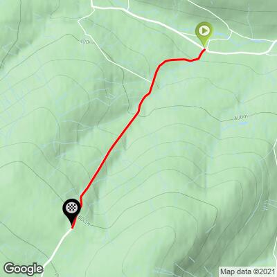
Ride 2.4 miles gaining 1,045’ at 8.3% average grade.

Chapel Fell, also known as Harthope Moss Pass, is tied for the highest paved pass in England with Killhope Cross, nine miles to the north.  Both passes are in the Pennines range - the backbone of England.  Expect high winds and panoramic views of the barren Pennine landscape as you climb.

Cycling Chapel Fell - aerial view of road traveling through pastureland, bike parked against fence post with PJAMM Cycling jersey draped across it, one lane road with stone house alongside it, PJAMM Cycling logo in corner

“Chapel Fell” is a peak to our left as we climb.

Pass through the quaint town of St. John’s Chapel (population 307 as of 2001) and ride up this challenging climb to the secondest-highest paved pass in England (after The Great Dun Fell, located just 20 kilometers to the west).

bike parked against stone wall along Marthope Road, sign for Langdon Beck

Before our second trip to the UK to document its wonderful and epic hill climbs, we contacted Simon Warren to ask him for his opinions regarding the Top 10 Most Epic and Top 10 Hardest Bike Climbs in England, Scotland, Wales, and the UK as a whole.  Simon ranks Chapel Fell as the seventh hardest bike climb in England.

 Cycling Chapel Fell - monument to WWI veterans

WWI Memorial just across from climb start.

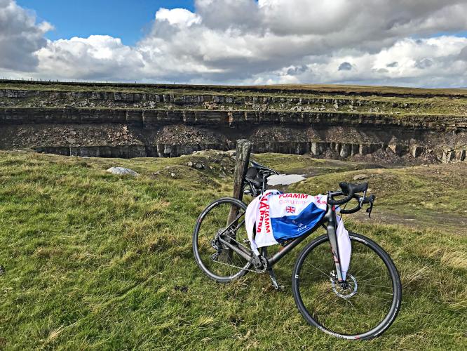
You’ll begin the climb up Chapel Fell from the small village of St. John’s Chapel. There’s a World War One monument in the village center, as well as a small grocery store, but not much else going on in town. The road is narrow as you exit town, but soon widens and even has a marked center line - not a given on many climbs in England! The gradient stairsteps a bit as you make the climb up to the summit point, where there is a now defunct quarry. There is a unique sign about halfway up the climb warning cyclists that foul weather is common on the route. It was windy and frigid on the day that I rode in early July, and I’d assume that is best case scenario -- weather wise -- on this climb. This is rural Northern England, and the climb has a very remote and unique feel to it. The hillside is grassy and the traffic is nearly all farming vehicles.

Cycling Chapel Fell - one lane road with pastureland alongside it, low stone fence, old stone building along side of road, blue sky with large white clouds

Mild grade the first 1300 meters.

photo collage shows sheep grazing in pasture, signs for St. John's Chapel and Langdon Rock, old farm buildings

The first few hundred yards of the climb have some interesting and fun sites.

Yellow street sign reads "Cyclists: This route is liable to poor weather conditions at all times"

Not today. 👍

views of green pasturelands along the climb

View of the same roadway - left photo up the claim and right photo a view back from about halfway up the climb.

aerial drone view shows road cutting through vast green pasturelands

A lot of sweeping views on this climb.

Cycling Chapel Fell - stretches of two-lane road winding uphill, green pastureland with horses and sheep grazing, blue sky, PJAMM Cycling logo in corner

The picturesque country road ahead of us during the calm before the storm!

The climb begins out of Chapel Fell and is also known as Harthope Moss, in the county of Durham in northeast England. The climb’s name originates from the mountain range to the left (east) at the top, which heads southeast towards Pennine Hills.  Chapel Fell Top is the highest point in the area at precisely 700m.  

This climb is only 20 kilometers from another top England climb, The Great Dun Fell, and is in North Pennines Area of Outstanding Natural Beauty:

“The landscape of the North Pennines AONB is one of open heather moors between deep dales, upland rivers, hay meadows and stone-built villages, some of which contain the legacies of a mining and industrial past. The area has previously been mined and quarried for minerals such as barytes, coal fluorspar, iron, lead, witherite and zinc.In 2013, a Canadian mining company were allowed to test drill for zinc around Allenheads and Nenthead. They said the region was sitting on a "world-class" deposit of zinc and predicted that a new mine in the area could produce 1,000,000 tonnes (980,000 long tons; 1,100,000 short tons) of zinc ore per year” (North Pennines).

photo collage shows aerial drone views of the Harthope Moss Quarries

Harthope Moss quarries.

aerial drone view shows PJAMM Cyclist standing with bike atop the abandoned Harthope Moss Quarries

Finish at the abandoned Harthope Moss quarries.

That’s a wrap!

Access to full Climb Summary requires a PJAMM Cycling PRO Membership!

It takes less than a minute to sign up & with your PRO membership you can:
  • Rate climbs, post comments and share your experiences on any of our climb pages
  • Create bucket lists of climbs & mark the dates you complete them
  • Weather data for all climbs - Start & Finish
  • Upload photos to your member page to customize your PJAMM Cycling experience
  • Utilize all of our interactive tools - Profile & Routes in Area
  • Download climb route .gpx files
LEARN MORE
SIGN UP

Already have an account? LOG IN HERE