
19.5
PDI
6.5 mi
DISTANCE
2,793 ft
GAINED
8.1 %
AVG. GRADE
FULL CLIMB STATS
INTRO
PLAN YOUR ROUTE
 We've partnered with Sherpa-Map.com to bring you the best route planning tool. With a PRO Membership you can use this climb as a reference when creating your route.
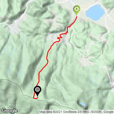
The climb averages 8.1% over 10.5 km (6.5 mi), with 851 m (2,793 ft) of gain. Grade is rarely easy for long: the steepest 100 yards (91 m) average 20.0%, the steepest 500 m (0.3 mi) averages 18.0%, and the steepest kilometer averages 15.4%.
Over the steepest 2 km (1.2 mi) the average is 12.9%, over the steepest 5 km (3.1 mi) it is 10.8%, and over the steepest 10 km (6.2 mi) it is 8.2%. In other words, the toughest part is in the upper half of the climb, where riders report the last 3 km (1.9 mi) averaging roughly 13%.
Roadway: The road is paved, but the surface deteriorates as you climb. Rider reports, including a 2025 one, describe worn asphalt in the second half of the climb, with patches missing entirely. The route enters Karkonosze National Park, so park regulations apply on the upper section. The Polish-side descent is the bigger hazard: riders warn of gutters across the road and recommend descending toward the Czech Republic instead.
Traffic: Traffic is not the main concern on this climb; the surface and the descent are.
Parking: Start in Podgórzyn near the Sosnówka reservoir. Park in the village rather than on the narrow park roads above, or base yourself in nearby Przesieka, Karpacz or Jelenia Góra and ride in.
Gear: A compact crankset is a must. Riders recommend something like a 34-tooth chainring with a 30 to 34-tooth rear cog for the upper kilometers. Bring a windproof layer, since the ridge is noticeably colder and windier than the village, and good brakes for the descent.
Provisions: Fill your bottles in Podgórzyn or Przesieka before the forest section. Little of the upper climb is served, so carry food for a ride that will take most riders well over an hour.
Before heading out on any cycling adventure check out our Things to Bring on a Cycling Trip and use our interactive check list to ensure you don't forget anything.
Podgórzyn sits at the foot of the Karkonosze (Giant Mountains) in the Jelenia Góra valley, and Karpacz, the main resort for the ride to Śnieżka, is next door. Przesieka, which the climb passes through, is known for the Podgórna waterfall and a pleasant walking-trail network.
Because the Polish-side descent is rough, many riders plan the day as a one-way crossing: up from Podgórzyn, then down toward Špindlerův Mlýn on the Czech side. If you do that, arrange your return logistics ahead of time. Other nearby climbs worth pairing: our Śnieżka (Karpacz) climb and Modre Sedlo (Pec pod Sněžkou).
The finish is a ridge crest, where conditions can differ sharply from the valley floor, so check current conditions before you go with our Weather tool.
ROUTE MAP
MEMBER RATING
CURRENT WEATHER
PJAMM TRIPS ADVENTURE STARTER BUNDLES
Check out PJAMM Adventure's prepackaged (self-guided) cycling trips. They will help you plan, document and conquer your next adventure.
NEARBY CLIMBS (0) RADIAL PROXIMITY
FROM No Climbs Found
MEMBER REVIEWS & COMMENTS
Let us know what you thought of this climb. Signup for our FREE membership to write a review or post a comment.
Already have an account?
LOG IN HERE
