
24.2
PDI
15.5 mi
DISTANCE
4,555 ft
GAINED
5 %
AVG. GRADE
FULL CLIMB STATS
Page Contributor(s): Ard Oostra, Switzerland
INTRO
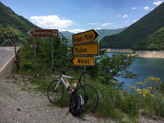
This climb leaves the shore of Piva Lake near Plužine and climbs the R-16 into Durmitor National Park, a UNESCO World Heritage Site since 1980 - 24.9 km (15.5 mi) with 1,388 m (4,555 ft) of gain at a 5.0% average grade, finishing at 1,882 m (6,176 ft) at the Prijespa saddle, the high point of the road's western approach.
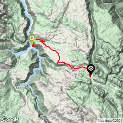
The opening kilometers are the most dramatic and the hardest. The road is carved into the cliffs above the lake and threads through a string of short rock tunnels, with views back down to the bridge and the deep green water. Around km 7 our route leaves the main R-16, which loops north through Trsa, for a quieter paved local road across the Pišče area, rejoining the R-16 around km 11.6. From there it's a long, steady climb across open high pasture and karst plateau past Boričje and Todorov Do, with the limestone peaks of the Durmitor massif rising ever closer.
From Prijespa the road drops roughly 150 m before climbing to Sedlo pass (1,907 m), Montenegro's highest road pass, about 6 km farther on, then descends to Žabljak. Many riders continue over Sedlo to complete the Durmitor Ring. The road is snowbound most of the year and is typically passable only from late May through October.
PLAN YOUR ROUTE
 We've partnered with Sherpa-Map.com to bring you the best route planning tool. With a PRO Membership you can use this climb as a reference when creating your route.
 Ride 24.9 km (15.5 mi) gaining 1,388 m (4,555 ft) at a 5.0% average grade, from 639 m (2,095 ft) at Piva Lake to 1,882 m (6,176 ft) at the Prijespa saddle.
The average hides a front-loaded climb. The first 3 km through the cliff tunnels are by far the steepest part of the route - the steepest kilometer averages 12.6% and the steepest 2 km 12.0%, and the steepest 5 km (8.8%) also starts down low. The grade then settles to 4-7% up to around km 10, where the route flattens and rolls across the Pišče area for a couple of kilometers. The rest is a steady 4-5% grind across the plateau, with one firmer kilometer near km 20 before the last 3 km ease almost to flat on the approach to Prijespa. There's 144 m (474 ft) of descent along the way.
Roadway: Paved the entire way, but narrow - the lower section is essentially a one-car-wide road cut into the cliff, and much of the upper road has few guardrails. The tunnels in the first few kilometers are short but dark, so bring lights. Winter snow closes the road, and it's usually open only from late May through October; rockfall and road damage are possible after the thaw or heavy rain. Check current conditions with the Auto-Moto Association of Montenegro (AMSCG, amscg.org) before you go.
Traffic: Light. The Durmitor Ring is a sightseeing road rather than a through route, so most of what you'll meet is tourist cars, small campervans (vehicles over 7 m aren't recommended) and motorcycles, and cyclists who have ridden it report having the road nearly to themselves even on summer weekends. Take extra care on the narrow cliff section and in the tunnels, where there's little room for vehicles to pass.
Parking: The simplest approach is to base yourself in Plužine, the small municipal center on the lakeshore about 2 km from the start, and ride across the bridge to the junction.
Provisions: Stock up in Plužine - its shops are your last reliable resupply. Water and food are scarce once you leave the lake, and the route skips the village of Trsa, so carry everything you'll need for the full climb and the ride on to Sedlo or back down.
Gear: Front and rear lights for the tunnels are essential. Low gearing helps on the steep opening kilometers, which come before you've had any chance to warm up. You finish at nearly 1,900 m on an open plateau where the weather can turn quickly, so pack a wind layer or jacket for the top and the descent.
Before heading out on any cycling adventure check out our Things to Bring on a Cycling Trip and use our interactive check list to ensure you don't forget anything.
Plužine sits on Piva Lake, a 45 km long reservoir up to 188 m deep, created when the Mratinje Dam was completed in 1975 - at 220 m, one of the highest dams in Europe. The flooding of the Piva Canyon also forced the relocation of the Piva Monastery, built between 1573 and 1586, which was moved stone by stone between 1969 and 1982 to the village of Goransko, about 7 km south of Plužine. It's a remarkable place to visit on a rest day.
Durmitor National Park, established in 1952, protects a limestone massif with dozens of peaks above 2,000 m, glacial lakes and the Tara River Canyon. Žabljak, over Sedlo pass on the far side, is the highest town in the Balkans and the park's main base, with the most accommodation and services in the area.
Conditions at nearly 1,900 m can be very different from the lakeshore - check current conditions before you go with our Weather tool.
ROUTE MAP
MEMBER RATING
CURRENT WEATHER
PJAMM TRIPS ADVENTURE STARTER BUNDLES
Check out PJAMM Adventure's prepackaged (self-guided) cycling trips. They will help you plan, document and conquer your next adventure.
NEARBY CLIMBS (0) RADIAL PROXIMITY
FROM No Climbs Found
MEMBER REVIEWS & COMMENTS
Let us know what you thought of this climb. Signup for our FREE membership to write a review or post a comment.
Already have an account?
LOG IN HERE
