
24.6
PDI
13.4 mi
DISTANCE
4,315 ft
GAINED
6.1 %
AVG. GRADE
FULL CLIMB STATS
Page Contributor(s): Bryant Robbins, Palmer, AK, USA
INTRO
Stinicia Port - Alan Top climbs 21.6 km (13.4 mi) from sea level at the Stinica ferry dock on Croatia's Adriatic coast to about 1,320 m (4,320 ft) on the high pastures of Alan, deep in Northern Velebit National Park. The average grade is 6.1%, with the steepest quarter-mile pitching to roughly 8.2% in the switchbacks near the top.
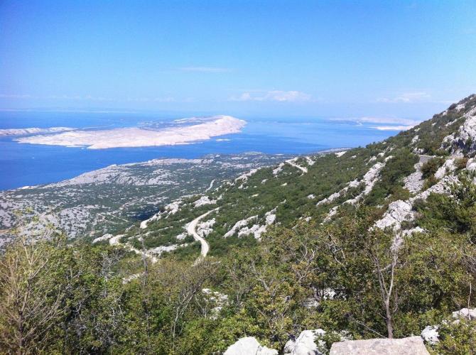
Also known locally as the climb to Alan (or Veliki Alan), it's one of the classic ways cyclists cross the Velebit range - the long limestone wall separating Croatia's Adriatic coast from its interior. Seven hairpins carry the road up through bare, rocky, largely shadeless terrain, opening to sweeping views back over the sea toward the islands of Rab, Krk, Pag, Sveti Grgur, and Goli Otok.
The road carries real history: a cable ropeway once ran from the Alan plateau down to Stinica cove, hauling timber cut on Velebit's slopes, built by political prisoners from the nearby Goli Otok penal colony. Traffic today is sparse to nonexistent - a function of remoteness, not any closure.
There's no water or food on the route until Mountain Hut Alan at the top, which runs on a seasonal schedule (see Gear & Provisions) - plan and pack for a long, exposed, sun-baked climb.
PLAN YOUR ROUTE
 We've partnered with Sherpa-Map.com to bring you the best route planning tool. With a PRO Membership you can use this climb as a reference when creating your route.
 This climb gains 1,315 m (4,315 ft) over 21.6 km (13.4 mi) at an average grade of 6.1%. The steepest quarter-mile averages 8.2%, and the steepest full mile 7.6% - both concentrated in the switchbacks in the upper third, where the road breaks out of the trees onto Velebit's bare karst slopes.
The lower two-thirds, following the old grade rising away from the coast, is comparatively gentle by comparison, so most of the real work on this climb comes late.
Roadway: The road is paved the entire way from Stinica to the Alan plateau, though rider reports describe patchy pavement in spots, particularly on the older switchbacks - expect some rough surface, not gravel. It's narrow with no guardrails and several blind hairpins, so ride the descent conservatively and don't cut corners on the bends.
Traffic: Traffic is minimal to nonexistent. This is a remote secondary road serving Northern Velebit National Park and a scattering of mountain hamlets, not a through route - riders have reported entire ascents without seeing another vehicle. The National Park's Alan entrance, and by extension the upper road, is only officially open roughly May through November; expect snow to close the top outside that window.
Parking: Stinica is a small ferry-port hamlet with a dock serving the island of Rab; there's roadside space near the D8 junction where the climb begins. Services here are minimal, so fuel up in Senj or another larger coastal town before heading out.
There's no water, food, or services anywhere on the climb until Mountain Hut Alan at the very top, and the hut itself only operates seasonally - broadly late May through October, with weekends-only hours in the shoulder months, and it's closed in winter. Carry all the food and water you'll need; the karst terrain has almost no shade and can get very hot in summer.
Because the road is narrow, occasionally rough, and has unguarded drop-offs on some of the steeper pitches, tires with a bit more width and puncture protection than the narrowest road setup are a sensible choice.
Before heading out on any cycling adventure check out our Things to Bring on a Cycling Trip and use our interactive check list to ensure you don't forget anything.
Stinica sits on Croatia's Adriatic Highway (D8), with a car ferry across to the island of Rab - worth combining with this climb if you're island-hopping the Croatian coast. The nearest towns with full services are Senj, about 40 km (25 mi) to the north, and Karlobag to the south, itself the base for Baške Oštarije, another climb over the Velebit massif into the Lika interior.
If you want to sample more than one way across Velebit on the same trip, our Routes in the Area tool can help you find other climbs nearby and plan a route connecting them.
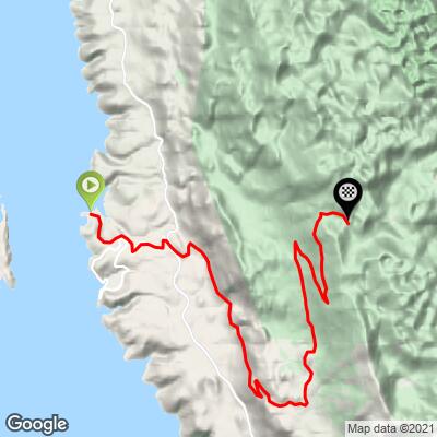
ROUTE MAP
MEMBER RATING
CURRENT WEATHER
PJAMM TRIPS ADVENTURE STARTER BUNDLES
Check out PJAMM Adventure's prepackaged (self-guided) cycling trips. They will help you plan, document and conquer your next adventure.
NEARBY CLIMBS (0) RADIAL PROXIMITY
FROM No Climbs Found
MEMBER REVIEWS & COMMENTS
Let us know what you thought of this climb. Signup for our FREE membership to write a review or post a comment.
Already have an account?
LOG IN HERE
