![]()
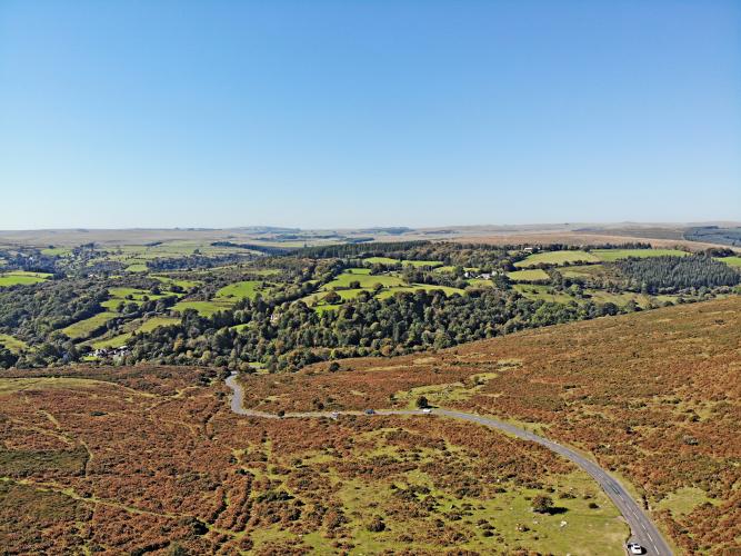
Helllloooooo Dartmeet - greetings at climb’s start!
The start of this climb is just past the bridge over East Dart River near where the Dart River tributaries, both the Rivers Dart East and West, meet - get it - where Rivers Dart Meet (Dartmeet).
This is a short but steep climb at 1 kilometer at 11.4%. We quickly climb out of the wooded area at the beginning of the climb into open space with unobstructed views of rolling hills surrounding the roadway.
![]()
East Dartmeet River from Dartmeet bridge at start of climb.
![]()
For the most part, unobstructed views on this climb.
![]()
We don’t mind that sign on the “back” part of our climb. 😊😊
Simon Warren writes of this climb:
“Tucked away in the south-east corner of Dartmoor, amidst a labyrinth of valleys lies the tiny village of Dartmeet, home to Badger’s Holt, the place where the east and west tributaries of the River Dart meet. This part of the country is hill-climbing paradise. Cyclists could spend days here and not ride the same hill twice. What doesn’t go up steep comes down steep, there’s not an inch of flat and to top it all it’s set in stunningly beautiful scenery. . .” 100 Greatest Cycling Climbs, A Road Cyclist’s Guide to Britain’s Hills (Simon Warren 2011, p. 26).
![]()
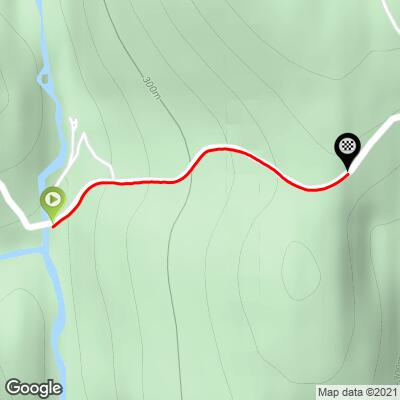
There is a parking lot at the exact location of the start because people park there to picnic and hike around the river. From there the climb goes straight up through some farmland and ends at a nondescript place on top of the hill
![]()
The steepest ½ kilometer begins at 100 meters (15%)
![]()
This Southwestern England climb in Devon County is smack in the middle of Dartmoor National Park (95,312 hectares / 235,520 acres) established in 1951 as a National Park of England:
“Dartmoor is an area of moorland in southern Devon, England. Protected by National Park status as Dartmoor National Park, it covers 954 km2 (368 sq mi).
The granite which forms the uplands dates from the Carboniferous Period of geological history. The moorland is capped with many exposed granite hilltops known as tors, providing habitats for Dartmoor wildlife. The highest point is High Willhays, 621 m (2,037 ft) above sea level. The entire area is rich in antiquities and archaeology.
Dartmoor is managed by the Dartmoor National Park Authority, whose 22 members are drawn from Devon County Council, local district councils and Government.
Parts of Dartmoor have been used as military firing ranges for over 200 years. The public is granted extensive land access rights on Dartmoor (including restricted access to the firing ranges) and it is a popular tourist destination.” Wikipedia - Dartmoor National Park
“Dartmeet is a short and very sharp climb – staring (presumably?) on the river Dart at Badger’s Holt (where some crazy people were in kayaks), you start climbing up a steep hill straight away and keep going for 9 minutes and then get off your bike quite tired! I was regretting bombing along the road previously (should have saved some energy) right from the get go. . . . The climb was beautiful though – even I could look across the moor as I suffered and respect the beauty and wildness of it all – a really lovely landscape.” http://100hillsforgeorge.blogspot.com/2012/01/hill-no-82-8-dartmeet.html
Dartmeet:
“Dartmeet is a popular tourist spot in the centre of Dartmoor, Devon, England at grid reference SX672731.
It lies at the end of the B3351 road, about 4.5 miles (7.2 km) east of Two Bridges. From here, the road continues eastwards as a minor road with restrictions on the size of vehicles,[1] past Poundsgate and over Holne Bridge and New Bridge to Ashburton on the edge of the moor. Immediately east of the river crossing, this road ascends Dartmeet Hill, a long steep hill that climbs 130 metres (430 ft) up the valley side.
As the name suggests, Dartmeet is the meeting point of the two major tributaries of the River Dart: the East Dart and West Dart. The road bridge, built in 1792,[2] spans the East Dart; just above it, at the side of the large carpark is an earlier, possibly medieval, clapper bridge, now partially collapsed. The actual confluence of the two rivers is just downstream of the bridge. Dartmeet is the official put in for the Upper Dart section of the River Dart for whitewater kayakers and canoeists.” Wikipedia - Dartmeet