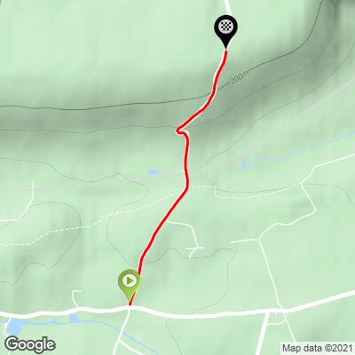
White Downs (SW #18) Bike Climb - PJAMM Cycling

0.8
FIETS
1.2 mi
DISTANCE
420 ft
GAINED
6.2 %
AVG. GRADE

FULL CLIMB STATS

INTRO

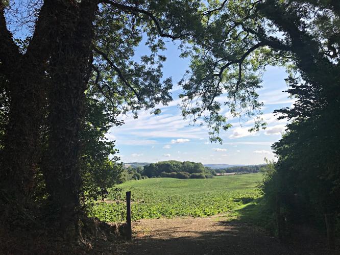
White Down Lane is a narrow and dark road in the heart of Surrey Hills Area of Outstanding Natural Beauty. This quaint and quiet country road, located about 21 miles outside of London, is surrounded by thick forest most of the climb.

See more details and tools regarding this climb's grade via our interactive Profile Tool.
Information Not Available

If you have any information regarding this climb, we'd like to hear from you. Click the CONTRIBUTE button to share your thoughts with us.

Information Not Available

If you have any information regarding this climb, we'd like to hear from you. Click the CONTRIBUTE button to share your thoughts with us.

Before heading out on any cycling adventure check out our Things to Bring on a Cycling Trip and use our interactive check list to ensure you don't forget anything.
Information Not Available

If you have any information regarding this climb, we'd like to hear from you. Click the CONTRIBUTE button to share your thoughts with us.

ROUTE MAP

MEMBER RATING

Not Yet Rated
-
Road
-
Traffic
-
Scenery

CURRENT WEATHER

PJAMM TRIPS ADVENTURE STARTER BUNDLES

Check out PJAMM Adventure's prepackaged (self-guided) cycling trips. They will help you plan, document and conquer your next adventure.
ALL TRIPS
Browse all of our prepackaged trips and find your next adventure!

NEARBY CLIMBS (0) RADIAL PROXIMITY

FROM
No Climbs Found

MEMBER REVIEWS & COMMENTS

Let us know what you thought of this climb. Signup for our FREE membership to write a review or post a comment.
Already have an account?
ROUTE MAP
PROFILE TOOL
Route Data
S.G. (%)
hide
Segment Data
hide

Climb Profile Not Found
CLIMB SUMMARY

Cycling White Downs

Ride 2 kilometers gaining 127 meters at 6.1%

There are a few breaks in the tree-lined roadway border, but not many.              


Steepest ½ kilometer begins at  the hairpin at 1.3 km (13.5%)

The Climb:

This quaint and quiet country road, located about 21 miles outside of London, is surrounded by thick forest most of the climb -- no sweeping scenic views on this one.  You’ll find this 2 kilometer climb heading out from Dorking along the A25.  

Don’t let this charming rural lane fool you, as RoadCyclingUK.com puts it, this is a climb that “bites in its second half, thanks to a false flat of a run up before hitting the corkscrew at the base of the steep rise.”  The first 400 meters of the climb are mild at 5.4% followed by a half kilometer of flat to descending roadway.  The “flat” section is followed immediately by a brutal half kilometer of double digit gradient (13.7% to be precise)!  As Broleur.com notes, on this ride, “the warning sign that things are about to get worse is literally a sign -- it reads 18%.  From there, it's time to get out of the saddle. You hit a hairpin and it's a solid grind.”  The remaining 700 meters of climb consist of intense grades, all the way up to 20%, all while gaining 90 meters of elevation (More).   Thankfully there is a flatter section of road right before the final 100 meters, and the road itself is in excellent condition, allowing for some minor respite on an otherwise killer ride (More).


At 900 meters, just at the end of the 170m 3.6% descent, is a bridge that crosses a railway.

This one isn’t as scenic as others on the UK Top 100 list, but, hey, we gotta check ‘em all!  

The surroundings:  

This climb begins at southern edge of the Surrey Hill Area of Outstanding Natural Beauty:

“Surrey Hills is a 422 km2 (163 sq mi) Area of Outstanding Natural Beauty (AONB) in Surrey, England. The AONB was designated in 1958 and covers one quarter of the county of Surrey. Surrey Hills AONB adjoins the Kent Downs AONB to the east and the South Downs National Park in the south west.

The highest summit of the Surrey Hills AONB, Leith Hill near Coldharbour, is 294 metres (965 ft) above sea level. It is part of the Greensand Ridge, which traverses the AONB from west to east, and is the highest point in southeast England.

The Surrey Hills area has three long-distance walks running through it: the North Downs Way, the Greensand Way and the Pilgrims' Way. Blackheath Common is also part of this area.

The northern ridge of these hills, predominantly formed by chalk, is separated by the Vale of Holmesdale which continues into Kent from the southern ridges which are predominantly greensand. They provide a haven for rare plants and insects. Parts of the area are owned and managed by the National Trust, including Ranmore Common, Leith Hill and Box Hill.

Chiddingfold Forest, a Site of Special Scientific Interest (SSSI), lies within the area.

Surrey Hills AONB is surrounded by an Area of Great Landscape Value which covers a further 8% of the county.”  
Wikipedia - Surrey Hills AONB 

Access to full Climb Summary requires a PJAMM Cycling PRO Membership!

It takes less than a minute to sign up & with your PRO membership you can:
  • Rate climbs, post comments and share your experiences on any of our climb pages
  • Create bucket lists of climbs & mark the dates you complete them
  • Weather data for all climbs - Start & Finish
  • Upload photos to your member page to customize your PJAMM Cycling experience
  • Utilize all of our interactive tools - Profile & Routes in Area
  • Download climb route .gpx files
LEARN MORE
SIGN UP

Already have an account? LOG IN HERE