![]()
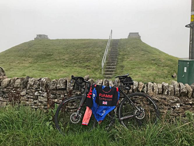
Finish - Socked in with fog on day we were here -
ancient stone walls along the way
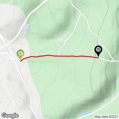
“Peaslows” as Simon Warren refers to it is essentially a straight 1.5 kilometer climb bordered by stone walls and wide open farmland and pasture. The climb hovers in the 8-10% range throughout and the steepest section is 140 meters at 13% beginning about 800 meters from the start.
![]()
Why and the heck is it referred to as “Peaslows”? While there is no sign for “Peaslows Lane” on Google Maps, or posted on the road that we could locate when there in September, 2018, nor via a Google Street View search back at the office, our research indeed reveals that “Peaslows” is in fact “Peaslows Lane.”
![]()
Sign at start - road turns to Peaslows Lane soon after (but not marked as such)
![]()
Steepest ½ kilometer begins at 800 meters (12%)
RoadCyclingUK.com:
“ Peaslows cuts a direct line up from the eastern edge of Chapel-en-le-Frith (no, we haven’t strayed into France), towards the locale of Sparrowpit. You can access it just off Sheffield Road, which cuts out the busy A6 junction.
If Peaslows is relatively unremarkable viewed on the map from above, it’s certainly challenging when you look at the profile that counts. For the first kilometre, you won’t see less than ten per cent, with peaks of up to 14 per cent along the straight road.
That makes it incredibly tough as there’s nothing to distract you from the task at hand, with the final 500m acting as a tease – it eases, but only just, necessitating you to switch on the afterburners, if you have any, to top this deceptively tough climb.” More
This climb is almost entirely in Peak District National Park - the UK’s first national park:
“The Peak District is an upland area in England at the southern end of the Pennines. It is mostly in northern Derbyshire, but also includes parts of Cheshire, Greater Manchester, Staffordshire, West Yorkshire and South Yorkshire. An area of great diversity, it is split into the northern Dark Peak, where most of the moorland is found and the geology is gritstone, the southern White Peak, where most of the population lives and the geology is mainly limestone, and the South West Peak, with landscapes similar to both the Dark and White Peaks.
The Peak District National Park became the first national park in the United Kingdom in 1951. With its proximity to the cities of Manchester, Stoke-on-Trent, Derby and Sheffield, and easy access by road and rail, it attracts millions of visitors every year.” Wikipedia - Peak District
The climb begins at the eastern edge of Chapel-en-le-Frith (population 8,638, 2011):
“Chapel-en-le-Frith - is a small town and civil parish in Derbyshire, England. Dubbed the "Capital of the Peak"—see Chapel-en-le-Frith Rural District Council—parts of the parish lie within the Peak District National Park, though the town itself is outside the Park boundary. The settlement was established by the Normans in the 12th century, originally as a hunting lodge within the Forest of High Peak. This led to the French-derived name of Chapel-en-le-Frith ("Chapel in the forest"). The population of 'Chapel', as locals commonly refer to it, was 8,635 in the 2011 census. For some years Chapel was the location of the High Peak Borough Council offices. The settlement has several public houses, hotels and guesthouses, a tearoom, a golf club, a cricket club and a football club.
Church of St Thomas Becket - The first chapel in the town (now the Church of St. Thomas Becket) was originally built by the Normans but was replaced with a larger building a hundred years later. It stands at the highest point in the town proper. The current building is now almost entirely of 18th-century construction above a crypt of 1225. Buried in the churchyard are soldiers of the Scottish army of the Duke of Hamilton who marched south in support of Charles I in 1648. After their defeat at Preston, they were marched to Chapel and imprisoned in the church for sixteen days in such squalid conditions that forty died; a further ten died when they were marched towards Cheshire. The Eccles Pike Cross stands in the churchyard, having been moved here from Ollerenshaw Farm in 1925. It is believed to be Anglo-Saxon and is covered in very worn carvings.” Wikipedia - Chapel-en-le-Frith