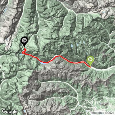
35.7
PDI
24.8 mi
DISTANCE
6,693 ft
GAINED
4.9 %
AVG. GRADE
FULL CLIMB STATS
INTRO
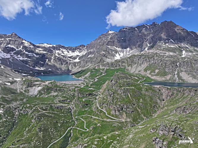
OH MY! Yes, this is a MUST DO climb, no doubt about it. This route has been described as one of the most beautiful climbs you have never heard of. However, judging from the many cyclists we encountered on the route on an early September Monday, the secret is out! The last third of this climb is among the most spectacular and breathtaking you will ever find. We were blessed with perfect weather, clear skies and blooming wildflowers for our one shot at this jewel. We rank this bike climb as THE World's Most Scenic Bike Climb - See our Top 10 World Most Scenic page.
PLAN YOUR ROUTE
The average grade is 4.9% (5.6% with descent eliminated from the gradient equation). 44% of the climb is at 0-5% grade, 41% is at 5-10%, and 7% is at 10-15%. The steepest 500 meters is 12.6% and steepest kilometer 11%.
See more details and tools regarding this climb's grade via the “Profile Tool” button.
Roadway: Narrow two lane road with no center stripe that ends just past the summit. The roadway is in good condition.
Traffic: Mild to moderate for the first third of the climb and minimal for the last two thirds.
Tunnel: You encounter a 3 kilometer tunnel at kilometer 14.8. We took the old road around the tunnel which was a fun (epic) experience (see Photos & Videos and also Full Summary for details).
Parking: There is public parking on the left soon after you enter Locana from the east - Map; Street View.
Provisions: There several cafés or bars to eat and get beverages on the way, the last at Lago di Ceresole at kilometer about kilometer 22.5.
Before heading out on any cycling adventure check out our Things to Bring on a Cycling Trip and use our interactive check list to ensure you don't forget anything.
We stayed in Turin and drove to the climb. From Turin you can also access several other great climbs such as Colle delle Finestre.
Use the “Routes in Area” button on the menu bar to see other bike climbs in this area.
ROUTE MAP
MEMBER RATING
CURRENT WEATHER
PJAMM TRIPS ADVENTURE STARTER BUNDLES
Check out PJAMM Adventure's prepackaged (self-guided) cycling trips. They will help you plan, document and conquer your next adventure.
NEARBY CLIMBS (0) RADIAL PROXIMITY
FROM No Climbs Found
MEMBER REVIEWS & COMMENTS
Let us know what you thought of this climb. Signup for our FREE membership to write a review or post a comment.
Already have an account?
LOG IN HERE
noahharney
most beautiful climb in the world
zvoneh
Beautiful and famous cycling paradise. ;-)