![]()
A Dream that became reality: Cycling on the roof of the world!
Two years ago, my wife Patricia landed by chance on the website of "Vlieg en Fiets" or "Fly and Bike" as the English translation is. They offered a cycling trip from Lhasa to Kathmandu via the Friendship Highway. The website also contained some pictures of the turquoise Yamdrok Tso Lake and of the snowcapped Himalaya Mountains. We were both interested and the plan to take this as our next holiday destination was born. The problem we ran across is that the complete cycling trip would be way too tough for Patricia, also a BIG member by the way, and hence she opted for a less tougher version were parts of the ascents would be done by car. This did not appeal to me as in that way I would not be able to claim the passes for the Asian continent as part of Zone 12. So eventually we dropped the idea and that was that. It was only last year when our daughter, who studies medicine, got the news that she could perform a part of her practical training in Nepal and she asked if we would visit her in Nepal. Which made Patricia say: "If we go then I would like to visit Tibet." Which intern made me say: "If we go to Tibet, then I would like to cycle!" So I contacted “Fly and Bike" and checked if they also provided an individual program besides of the group program they offer for the Friendship Highway cycling trip. They didn’t. So I searched the Internet and found some companies that might provide a package that was tailored to our needs. I.e. I would cycle, but only the ascents and the descents and flat parts would be covered by car. After some searching I came in contact with a travel agency called Passaat Verre Reizen (Passaat Distant Travels). A small company that were willing to help out and the owner helped me to come to a package that would fulfill our needs and that would take care of the altitude adjustment. I had many, many questions and all were answered and suggestions went back and forth until we finally settled on a final travel ternary. We would fly to Chengdu in China and spend one night there and the next day visit the Giant Panda breeding center. Which we liked as it was fun to see and hear the lazy Giant Panda's chewing away the bamboo.
![]()
From Chengdu we flew to Lijiang, our first step to get accustomed to the height as Lijiang lies on2600m. Lijiang has a beautiful old town where the Naxi people dance on the main square in their traditional clothes. And little streams run along the middle of the cobbled streets and there are the turning water wheels of course. We also visited the Black Dragon Pool Park. The owner of the guesthouse we stayed at, Eric Yang from The Moon Inn, learned us about pu-ehr tea and Dianhong tea. And I can recommend both kinds of tea to you. But note that you have to brew the tea totally different than what we are used to here in the west! From Lijiang we moved on to Zhongdian or Shangri-La as it is nowadays also known. And on the way we visited a very tiny part of the Tiger Leaping Gorge. On our way to Zhongdian we saw more and more the Tibetan influence as it used to be the part of the most southeastern area of Tibet before the Chinese invasion of 1950. Zhongdian would be the second step to get used to the height as Zhongdian is at 3300m. I had found a website from a Swiss cyclist (Beat Heim and the website is: http://www.betzgi.ch/en/) who had cycled in the Himalaya's amongst others and he described a pass near to Zhongdian. Ideal as a test to see if we would be ready to cycle at altitude. At start Patricia had said she would not come along when I would cycle but over time
she agreed that we would rent a 2nd MTB so she could give it a try on the passes that were not so long. And so she accompanied me when we tried for the first time to cycle at altitude to Zhongdian Pass. We rented 2 good MTBs for 300 Yuan (~ 30.00 Euro) for the whole day. And we paid 1000 Yuan bale as we did not want to leave our passports behind.
I had taken the waypoints from the Swiss cyclist and had programmed these into my GPS. The map I hadtaken from Open Street Map (http://garmin.openstreetmap.nl/, tick the box for manual selection and then select the parts of the map you want and it will be mailed to the email address you filled in. Dutch manual on: http://www.gps-info.nl/tips-trucs/openstreetmap/) as I did not have a map that covered the part of China nor Tibet or Nepal that we visited.
This map served us very well! So based on the GPS indications we cycled out of Zhongdian as the foot of the pass is just outside Zhongdian and we started to cycle from 3294m. Traffic in Zhongdian was busy, noisy and smelly! Outside Zhongdian, traffic got less but the trucks still produced a lot of smelly exhaust fumes when they passed us by :-( It took 15km or so before the road got nice and quiet and we could appreciate the nice sunny weather and the cycling. We saw Yaks in the rocky, barren fields with their calves and nature took over from men (no houses). Nice! The ascent towards the pass is 22.5km long and on our way up we also noticed a small stupa made out of stones and Mani stones. Mani stones are stones where a mantra has been engraved in like for instance: Om mani padme hum. This is the most well-known mantra. We reached the top of the pass at 3576m but the waypoint I had from the Swiss cyclist indicated it was a little further away still. I should have trusted on the fact that we saw prayer flags above the pass as when we cycled further the road only went down.
![]()
Zongdian Pass
And since the BIG meeting in Oberstdorf, I now know that the top of the pass is where the road has reached the highest point. I.e. just before the road goes down again ;-) So the climb was not too tough as over the 22.5km we gained 282m. On average just 1.25%. When looking closer to the profile we can distinguish 2 parts. The 1st part is 16.22km long and then we gained just 89m (0.55% on average). The second part is steeper and is 6.14km long and 194 altimeters need to be gained (3.15% on average). Yeah, I know, it's still not very demanding but remember that we are cycling above 3200m here! And it was good to find out how our bodies coped with cycling at an altitude. We did not encounter any problems. Except for some dogs that chased us when we descended. But we increased speed, as dogs here can have rabies (so get the injections), and that solved that problem also. In the afternoon we visited the Gompa (temple fortification) that is located on the top of hill in the old town and next to it is a gigantic prayer wheel, 24m tall. One of the biggest prayer wheels in the world. And it took at least 8 people to get it rotating clockwise to spread the prayers.
![]()
Gompa & Giant Prayer Wheel
There was also a nice stupa in the town with prayer flags hanging down from the top and many small prayer wheels in the base.
![]()
Stupa
Zhongdian is a nice town well worth a visit.
The next day we flew to Lhasa. We were very lucky that we had received a permit for Tibet while we were in Zhongdian as from one day to another the rules of the Chinese government changed and it was only allowed to enter Tibet in groups of 5people with the same nationality. We were among the last ones who were allowed to enter Tibet with just 2 persons. In Lhasa our driver (Jambel) and guide (Dhundup) welcomed us by putting a Khata (white scarf) around our neck. They would accompany us for 13 days when we would travel through Tibet via the Friendship Highway from Lhasa to Kathmandu in Nepal. We first spend 3 days in Lhasa at 3600m and visited the Potala and Norbulinka palaces of the Dalai Lamas.
![]()
Potala Palace
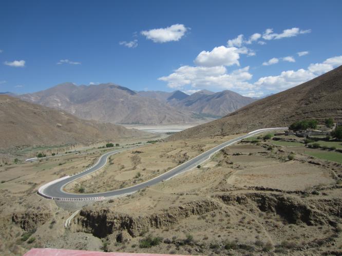
And the Jokhang temple, the spiritual heart of Tibet as many pilgrims come to it. And we visited the Deprung and Sera monasteries. We cycled the last 2km to the Deprung monastery which have an average gradient of 7.2%. And even that felt OK at 3600m! Again a good indication. Note that the MTBs we had were arranged via the traveling agency in The Netherlands already. So after 3 days we left Lhasa and got going on the Friendship HighWay (FHW). I had bought a book called "Himalaya by bike" (from Laura Stone) that describes 7 routes in detail with maps and profiles and 1 in text and one of these detailed routes is the FHW from Lhasa to Kathmandu. I had read about the blue Buddha 25km outside Lhasa and so we visited this place before we drove another 60km to the foot of the first pass called Kampa La. La is the Tibetan word for Pass. And Kampa La is one of the bigger passes on the FHW as the height difference is 1186m and with a length of 23.8km this results in an average gradient of 5.84%.
Laura Stone writes that passes in the Himalaya are never that steep as the old busses and old trucks that are used in Tibet also need to climb them :-) It was warm and sunny so before I started cycling I used enough sun burn cream to avoid a sun burn as that is easy to get when it is sunny at this altitude. So I cycled in shorts and with short sleeves and it went extremely well. On the flatter parts I even could put the chain on the middle cog in the front and increase my speed. On the way up I saw yaks and people who passed me by hung out the window to encourage me or to take pictures of this strange person who took a bike instead of a car to get up. The views on the way up are not that special as Tibet is rather barren. It's only when you arrive at the pass, greeted by many prayer flags, when a fantastic view is offered on the turquoise colored Yamdrok Tso lake.![]()
Tamdrok Tso Lake
I realized that this was the highest point I ever reached by bike. In Peru I cycle up to the Portichuelo de Llanganuco pass and though I did not reach the pass I managed to cycle up to 4,440m. The summit of Kampa La is at 4,773m and I had to ask someone else to take a picture as Patricia had gone to the Yamdrok Tso lake to walk there with our guide. So I called them and then descended downwards to the lake. I seem to have passed them at as some stage they came driving next to me. We stopped at the first available place where we had our lunch. Our guide arranged for every "biking" day a lunch box with some bread, a hardboiled egg, a piece of fried chicken, an apple and something to drink. The content depended on what he could get his hands on in the different villages we stayed. The lunch tasted good after the exercise and when ready we drove along the lake shore to our next stop: Nagartse. There was only one hotel that looked good in Nagartse but they refused free admission for our guide and driver and hence we decided not to stay there but take a very simple hotel together. No shower nor running water in the room. There was however a thermos bottle filled with warm water. The toilet was outside and one had to flush by taking water from a large barrel and poor it into the French toilet. I might have done too much on the climb as I felt a mild headache and I did not fancy dinner (tough I did eat something). The classical symptoms that point to altitude sickness. Nagartse is situated at an altitude of 4,452m and that also has an impact of course. There are some simple rules to obey to prevent altitude sickness:
- Take the time to get used to the altitude (we did that by going to 4452m via Lijiang at 2300m (stayed 1 day) drove in one day to Zhongdian at 3300m (stayed 1 day) and then flew to Lhasa at 3600m (stayed 3 days).
- Drink enough as the altitude tends to dehydrate the body. We knew this from the time we were in Peru and where our guide kept insisting us to drink. So we drank a lot of tea in Tibet and I took water along whenever I cycled.
- Take it easy. I.e. don't do too much.
- The altitude of the place where one sleeps in the evening should not be more than 300m higher then where on started when being above 3000m. Note that it's OK to cross a pass with a greater height difference as long as the overnight fulfills the above requirement.
It's these last 2 rules that I did not adhere to as we gained 852m that day and I had cycled up Kampa La as fast as I could. My body indicated clearly that I was overdoing it. There is not much to say about Nagartse. There is no reason to go there but in our ternary it was to most convenient stay over. The next day I had planned to cycle Karo La and Simi La. But I again did not fancy eating something. I had a vegetable soup for breakfast just so I had eaten something.
Patricia did not want me to cycle. But I wanted to try first to see how it would feel before I would give up. And I indicated that I would quit if it did not feel good. The foot of Karo La is in Nagartse so that's easy. Patricia would also cycle this pass as it's not a very tough pass. The first 23km you only gain 346m and the average gradient is just 1.5%. Some8km outside Nagartse the road starts to follow a small river. Winds coming from the glaciers are funneled into the valley and hence it's a cold ascent even though the sky was clear. I borrowed my Gore-Tex jacket to Patricia and took her loose arm sleeves to keep my arms warm. This ascent provides superb views on the snowy peaks of Jetung Chusang (6,242m) and Jansang Lhamo (6,324m) and due to the low gradient the cycling went fine and my slight headache did not increase. It was cold though as Patricia cycles slower than me and I could not get warm from the cycling. The last 6.2km have an average gradient of4.68% but the ascent really starts when the road turns away from river up to the pass after 26km. We were glad that we finally saw the colorful prayer flags that mark the Karo La pass at 5046m so we could get in to the warm car. I even enjoyed my lunch and the fried chicken tasted great. We also enjoyed the stunning view on the glacier that comes down from Nojin Kungstang (7,190m) and almost reaches the road.
![]()
Glacier Nojin Kungstang
Ok, on to Simi La. This is a tiny pass that is just 1.7km long so it's goo I started cycling earlier. The temperatures were better here and though I stared with the arm sleeves on it did not take long before I could do without them. In this 1.7km I gained 85m. So again the average gradient is just over 5%. The pass lies at 4361m and is there so the road can bypass an artificial lake that is used as a reservoir for a dam to generate electricity. Again many prayer flags at the top but also Tibetans were there trying to sell prayer wheels, prayer flags, etc. And also small square pieces of paper with mantras and a windhorse on it. These are used to throw into the air when you reach the pass and you have to yell:"Tsu, tsu!" It's a ritual to increase your well-being or good luck. As in this way you spread the mantra over the world.
![]()
Simi La lake
Simi La is just a glitch in the descent towards Gyantse. The Gyantse Dzong (fortress) can be seen from far as it lies on a rock high above the city.
![]()
Gyantse Dzong
Two other things to visit in Gyantse are the Pelkor Chode monastery and Kumbum. Hence we stayed 1 day in Gyantse. In this monastery you are allowed to take pictures (unlike in the Jokhang Temple or Potala Place) and the price is fair! Unlike other monasteries like Tashilumpo in Shigatse. After the Pelkor Chode monastery we visited the Kumbum. The Kumbum is in fact a three-dimensional mandala. A mandala is used to focus your thoughts when meditating and it consists of a square with four gates containing a circle with a center point. So picture this as the ground floor and on top of that another mandala has been built that is a little smaller and again and again. And then the top has a stupa like golden structure with the parasol on the top as a protection for the evil ones. The Kumbum is filled with many Buddha's as Kumbum means: One hundred thousand holy images.
![]()
Kumbum
From Gyantse to Shigatse (the 2nd largest city in Tibet) is not so interesting. As the road is nearly flat. In fact it descents 200m even. Our guide tried to make it a bit interesting by visiting a Tsampa grindery. Here roasted barley is grinded into Tsampa flour which is the basic Tibetan breakfast together with butter-tea. In Shigatse we visited another monastery: Tashilumpo. By now we have seen enough monasteries. You tend to get monastery-tired so to say even though the frescoes of Buddha and the status are beautiful. We did perform a Kora around Tashilumpo. It's a pilgrimage and meditation by making a walk, clockwise, around a sacred site or object (stupa, monastery). I gave every prayer wheel a spin that we passed and stopped counting them at 3,000. Spinning the prayer wheel is good for your Karma in case you wondered why I spun all of them. From the monastery walls we also saw the Shigatse Dzong. Which is not as nice as the one in Gyantse. On the square in Shigatse that lies in front of the monastery there is also a bronze statue of a cyclist. Worth a picture of course! OK, time to move on to the next pass: Tra La. This is again a glitch in the road. From Shigatse it's about 27.5km to the top of Tra La at 4041m so you only gain 194m.An average gradient of 0.7%. This is due to the fact that after an initial ascent a short descent followed before the road took us again to the pass. Did you notice the "us"? Yes, we cycled this pass together! OK, on to Lagpa La. Lagpa La starts like Karo La with a more flat piece which is 45km long and this part has an average gradient of just 1.1%.It's only after the 5005km marker (that is 5005km from Beijing) that the ascent really kicks in. Over the last 8.1km we gained 279m to get to the summit at 4538m (still just 3.4%).This pass was the one decorated with an abundance of prayer flags. Really nice!
![]()
Foto Lagpa La
On our way up we again saw strange transports. Cows side to side on a small pickup truck or a complete family with their stuff packed on a trailer pulled by a tractor-like contraption. Amazing!
![]()
From the top we descended to Lhatze. Again just a convenient stop over for us as there is really no other reason to stop in Lhatse. On Patricia's birthday we moved from Lhatse to Shegar. Just outside Lhatse started my climb to the highest pass on the FHW: Gyatso La (5,253m). But first we had to go through yet another police checkpoint. I have not mentioned these but at several places our guide had to show our so called Alien Travel Permit (ATP) to show we were allowed to travel in that part of Tibet. Anyway. on to Gyatso La. It's just over 28km of cycling at 4.44% on average. The road up follows Druwu Chu (river) for most of the distance. I saw people at work on the land and it's amazing to see how much labor is still done by hand. There are some tractors but most of the plowing is done with cows or yaks that are dressed up with red plumes. The first 2/3rd of the climb went good but the last part I had quite some headwind that slowed me down and made me cold also. I had to stop to put on my windproof jacket and gloves. I saw a cloud lingering just above the mountains. It looked so close that I could touch it by just stretching out my hand. I was so glad when after the last turn I saw the prayer flags hanging down from the Quomolangma National Nature preserve sign. This gave new energy, a little though, to cycle the last 1.5km. The last meters a Chinese chap ran along while his mate was taking pictures. Tears came to my eyes when I cycled below the Quomolangma National Nature preserve sign. I made it, tired but satisfied of course that I reached this highest point of our journey.
![]()
Gyatso La
Ok, quickly into the car to get warm and to descend to Shegar where I decorated our room with balloons and postcards of friends and family that I had smuggled along for Patricia's birthday. Our guide sung a birthday song in Tibetan after I sung a Dutch birthday song. A nice gesture from our guide. The next day I had my first graveled pass as the FHW has good tarmac but the detour to Everest Base Came (EBC) is all gravel road. Yes, on to Mount Everest! I had found a beautiful picture on the Internet taken from Pang La (pass) showing in front of a blue sky Lhotse & Mount Everest framed by prayer flags above and below. Beautiful! But the chance to catch Mount Everest free of clouds is slim. Well, not to worry, let's first take on Pang La. The graveled road is bumpy and every passing car covers me in dust clouds. But I pushed on of course! As I make my way up I see the hairpins below me as a giant serpent crawling up against the mountain. It's due to the bumpy road and 924 altimeters that need to be covered that the ascent does not come easy and again I was glad to see the prayer flags of Pang La (5,199m). We were really lucky as we had the perfect view on the Mahalangur Himal range with 4 out of the in total 14 eight thousanders against a blue sky. From left to the right we saw Makalu (8,4635m), Lhotse (8,516m), the famous North Face and summit of Mount Everest (8,848m), Gyachung Kang(7,952m) and Cho Oyu (8,201m). It was stunning!
![]()
![]()
Pang La
Mount Everest's North Face is like a magnet it keeps pulling your view. I sat down and enjoyed my lunch together with Patricia. We did not need any words. It was tough to get up and get into the car for the bumpy ride to the Rongbuk Monastery. While we came closer to the Rongbuk monastery Mount Everest filled the view completely. The North Face is huge! I had read about the summit attempt of Irvine and Mallory and hence I could recognize with the naked eye the yellow band and the first, second and third step on the ridge that leads to the summit. I could see how steep the notorious second step is even. The step that plays such an important role in the Irvine and Mallory mystery.
![]()
Everest North Face
We stayed in the tourist camp with a Tibetan couple who hosted us in their tent. From there we walked up to the EBC. Well, as far as you are allowed to go that is as even there we had to show our permits. We climbed up a small hillock and got out of breath at that altitude (5,200m). We could imagine how tough it would be for climbers on Everest. The night was cold but fortunately we had good sleeping bags. In the morning Everest was again the eye catcher. The air was crystal clear and so was the awesome view. Ok, we had to leave and I was able to squeeze in another climb. As soon as we crossed the bridge near to Chosang I started to cycle up to Lamna La (5,086m). This is again a graveled road but even worse than the one that lead up to Pang La. Even the front suspension was not enough and I could have done with a full suspension MTB on this ascent. The front wheel moved to all sides and it was hard to keep going due to this. I could not recall the reasons that I wanted to cycle this pass also. The pass itself is barely marked as a pass. Just some stones and Khatas. But it was good that the marking was there as it did not look like a pass at all as it's located on a plain.
![]()
Lamna La
On to Tingri which was hard labor but now for our driver. The end of our Tibetan adventure got into sight now as the next day I had the last 2 passes in Tibet on the program. The road from Tingri to the foot of the first pass is flattish (222m over 66km). The first pass is Lalung La and it's just 11.2km to the summit at 5,015m but this pass and the one that follows are well known for the strong headwinds. So I started with a jacket, long trousers and gloves even as there was a cold wind in the valley where the Men Chu River flows. The climb is not so hard, 3.8% on average, but due to the headwind it didn't come easy. I thought that by now also the altitude would no longer be a problem. So I had hoped this pass went easier. But the sun was shining and as I went higher the wind was no longer a problem and I could do without the extra clothing. Patricia, our guide and driver were waiting at the pass. Ok, on to the next pass of this double pass: Yarleshung La (5,125m). A 5km descend brought me to the foot and then only 272m have to be gained over 7.6km to get to the last Tibetan pass. On my way up I got a better and better view on the Labuche Himal range. But it's the view from Yarleshung La that is really stunning.
![]()
Yarleshung La
A 180 degree view on snowcapped Himalayan mountain peaks like Labuche Kang (7,637m) and Shishapangma the smallest of all 14 eightthousanders (8,014m). A beautiful and impressive view. This pass is also being used for sky burials. The Tibetan burial ritual and one can see the remains like clothes of the deceased. Time for the longest descent in the world as we descend from 5,125m down to Dolaghat at 638m over 150km. But we made a stop in Zhangmu (2,320m) first as we needed to cross over via the Friendship bridge to Nepal. When going down, the scenery gets greener and it was only when we were in our hotel in Zhangmu that we heard birds sing that we realized we didn't hear that for the last weeks. Zhangmu is glued to the mountain side and the hairpins that make up the only street it has are jammed with colorful Nepali trucks making their way down to the border. We crossed the Friendship Bridge the next day and had to say goodbye to our Tibetan guide and driver. After a thorough inspection of our luggage by the Chinese soldiers we could pass and we were handed over to a Nepali man who guided us along the Nepali customs and then handed us over to our Nepali driver who drove us over a much worse road (the Chinese part up until the border is a very good road) further down to Dolaghat. I had one more ascent planned. The climb from Dolaghat (638m) up to Dhulikhel (1,502m). So after we had our lunch I got going. I was glad I brought a bandana as this helmet was old and smelly. And the MTB was also not so good. Note that cycling in Nepal also means that you cycle on the left hand side of the road. While I made my way up I was followed by our driver and Patricia.
![]()
On Dhulikhel
It's so green here after Tibet and so busy also. Much more people and houses everywhere. I was passed by by cars and busses. And the busses are packet with Nepali and even have Nepali on the roof sometimes! I also saw a goat on the roof of a bus :-) Incredible. Shifting gear was tricky so I only shifted gear on the front but at some stage even that went wrong and the chain got off and stuck between the frame and pedal. I got dirty hands when untangling the chain and putting it back on. It was only when I reached Dhulikhel when I found out that our driver had picked up an extra passenger. Who he did not introduce even. Initially our travel agent had planned that we would stay in Dhulikhel but we had asked to be rebooked to Bhaktapur which was once the capital of Nepal during the great Malla Kingdom until the second half of the 15th century. This I can recommend to you. Bhaktapur is beautiful and really worth a visit! As we stayed there we could explore the town also after the majority of tourists were gone which is perfect.
![]()
Bhaktapur Durbar Square
Then on to Kathmandu. Kathmandu is chaotic, noisy and full of life. I liked it! As with Bhaktapur, I will not write what you should visit here. But if you are planning to go there then you can always send me a mail (helmuth_dekkers@hotmail.com) and I will tell you from our experiences what you should see. We did by the way not visit our daughter in Dharan as there was a huge strike there due to the new constitution that should become active. But our daughter came with some difficulties to Kathmandu where we enjoyed some nice days together. Not what we had in mind but we have learned that even when things work out differently that we should accept that and make the best out of it. Overcoming setbacks is good for your karma.