![]()
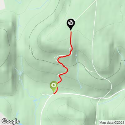
This is a popular climb (4,226 Attempts By 5,964 People - Strava OFFICIAL 100Climbs No56 White Horse Bank) and quite challenging from the start. The first 1.2 kilometers of the 1.5 total average 13.8% before relaxing to 1.6% for the final 300 meters.
![]()
Namesake of the climb.
This climb gets its name from the white horse figure cut into the hillside, originally in 1857 (restored 1925) 800 meters up the climb, just above the White Horse Car Park on your right. The horse was created by removing the topsoil to expose the white sandstone beneath.[1]
![]()

Welcome to White Horse Bank climb!
![]()
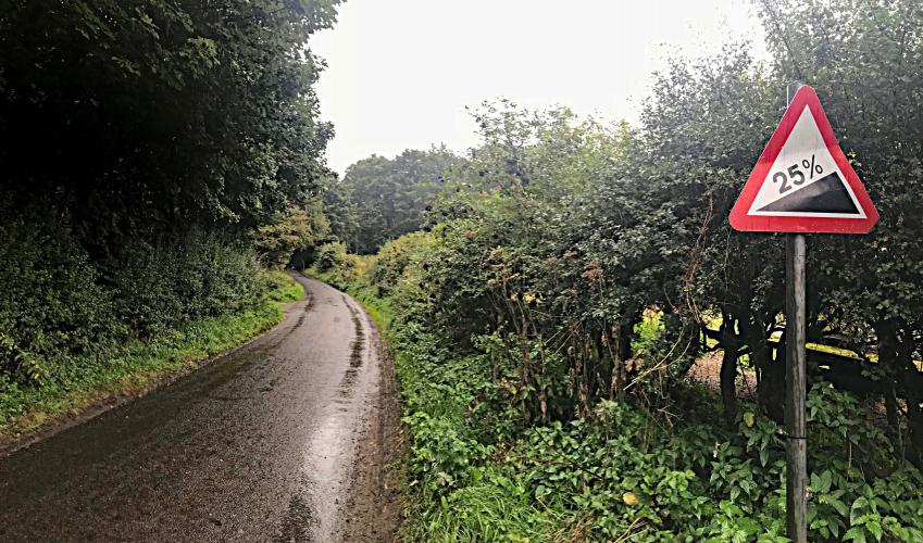
Steepest ½ kilometer begins at 100 meters (14.9%)
Steep lil thing in what feels like the middle of nowhere. It was wet and fogged in when I rode it. There is a parking lot near the start where it looks like people hike from. There is nothing at the top. I think there is mountain biking on the mountain nearby. Saw a couple mtb’s
#56 of Simon Warren’s 100 Greatest Cycling Climbs in Britain begins just north of the tiny North Yorkshire village of Kilburn (pop. 227, 2011):
“Kilburn is a village in the civil parish of Kilburn High and Low, in the Hambleton district in the county of North Yorkshire, England. It lies on the edge of the North York Moors National Park, and 6.2 miles (10.0 km) north of Easingwold.
History
The village is mentioned in the Domesday Book as "Chileburne" in the Yalestre hundred. At the time of the Norman invasion the lord of the manor was Arnketil, but was subsequently granted to Hugh, son of Baldric. During the reign of Henry I the manor was passed to Rouen Cathedral in Normandy and subsequently to Roger de Mowbray who passed the lands to the Colvilles. In return for receiving these lands, Thomas de Colville had to swear allegiance to Roger de Mowbray. The Colvilles held the manor until 1405 when the eighth Thomas Colville was murdered outside York and died without male heirs. The lands were held by the Archbishop of York after the dissolution of the monasteries in the 16th century.
Kilburn was historically a township and parish in the wapentake of Birdforth in the North Riding of Yorkshire. After 1837 it was part of the Thirsk and Helmsley Poor Law Unions. The parish, which covered 5,900 acres (24 km2) acres, comprised Kilburn, Oldstead, Thorpe-le-Willows, and Wass, of which Kilburn had the largest population. The etymology of the name comes form two Old English words, ciele & burna, meaning "cool stream".
Robert de Alneto, a monk from Whitby Abbey lived in a hermitage at Hood Grange, 2 miles (3 km) from the village. In 1138 Robert de Mowbray converted it into a Cistercian abbey, which later moved to Old Byland and subsequently moved again to Byland.” Wikipedia - Kilburn, North Yorkshire
CyclingUphill.com:
“Unlike many climbs in the North York Moors, the builders made some effort to build in mini hairpins to reduce excessive gradients. It gives the climb an average gradient of 10%. However, don’t expect a smooth Pyranean climb, because they left in an introductory segment of 20-25% just to keep in with the tradition of North York Moor climbs. After that the worst is over, but it is still a long slog over a variable gradient, making an impressive height gain of 174m in just one mile. The climb takes you to the top of Kilburn Moor. At the base of the climb, you can see the impressive Kilburn White Horse on the slopes of Kilburn Moor.” More
100HillsForGeorge.blogspot.com:
“The climb starts out pretty gently and you can keep the legs just turning over and powering through - it isn't too bad here, but then it really ramps up - and starts to justify the plentiful 25% warning signs that you see both on the way up and the way down!” More
This climb is at the very southeastern tip of North York Moors National Park, established 1952 with 143,000 hectare (353,361 acres):
“The North York Moors is a national park in North Yorkshire, England, containing one of the largest expanses of heather moorland in the United Kingdom. It covers an area of 554 sq mi (1,430 km2), and has a population of 23,380.[1] The North York Moors became a National Park in 1952, through the National Parks and Access to the Countryside Act 1949.
To the east the area is clearly defined by the impressive cliffs of the North Sea coast. The northern and western boundaries are defined by the steep scarp slopes of the Cleveland Hills edging the Tees lowlands and the Hambleton Hills above the Vale of Mowbray. To the south lies the broken line of the Tabular Hills and the Vale of Pickering.
Four roads cross the moors from north to south. In the east the A171 joins Whitby and Scarborough. Further inland, the A169 runs between Pickering and Whitby. More centrally, a minor road departs from the A170 at Keldholme and passes through Castleton before joining the A171 which connects Whitby and Guisborough. The most westerly route is the B1257 connecting Helmsley to Stokesley. The A170 from Thirsk to Scarborough marks the southern boundary of the moors area.
The Esk Valley Line is an east-west branch line rail link from Whitby to Middlesbrough in the north and the North Yorkshire Moors steam railway runs from Pickering to Grosmont with a link to Whitby.” Wikipedia - North York Moors National Park