![Cycling Cat & Fiddle, England Cycling Cat & Fiddle, England - historic Cat & FIddle Inn at climb's finish, old brick building, blue skies]()
Cycling Cat & Fiddle, England’s Peak District.
The Historic Cat & Fiddle Inn at top of climb.
Cat and Fiddle hosted the British National Hill Climb Championships in 2002 (Mark Lovatt).
![Cycling Cat & Fiddle, England Cycling Cat & Fiddle, England - photo collage, road signs noting Police Notice - Aircraft Traffic Enforcement along roadways, long stretches of roadway throughout green pastureland, large stone circular monument, PJAMM Cycling logo in corner]()
Many roadway signs to warn racing motorcycles and automobiles.
This ride is #70 on Simon Warren’s Greatest Cycling Climbs list, and is a long one at 11.3 kilometers. This mild climb (3.5% average) travels along a busy highway and enters Peak National Park at kilometer 5. The road has several turns that are heavily marked with warning signs due to many previous accidents, many of which involved motorcycles.
![Cycling Cat & Fiddle, England Cycling Cat & Fiddle, England - aerial view of long stretch of road stretching through pastureland, sunrays shining down through clouds]()
At the end of the route is the climb’s namesake Cat & Fiddle Inn, which originally opened in 1813 and closed in 2015.[1]
As previously noted, this is a mild climb averaging only 3.5% with the steepest 500 meters only 6%. There are three short descents in the middle of the climb, the longest being 450 meter at -2.9%.
Roadway Surface and Traffic Report: The roadway along this climb is in pristine condition. Traffic is moderate and moves at a good clip, but the roadway is a wide two-lane and we felt safe along the way.
![Cycling Cat & Fiddle, England Cycling Cat & Fiddle, England - rusted posts along roadway in green pastureland]()
Open views of farmland along this climb.
![]()
Steepest ½ kilometer begins at kilometer 4.6 (6%).
Simon Warren’s 100 Greatest Cycling Climbs:
“The A537 out of Macclesfield over to Buxton is named after the remote Inn at the top and is a favourite with cyclists and motorcyclists alike. Beginning in the centre of Macclesfield and heading out of town, you gradually leave the congestion and noise behind you. The surface is very rough to begin, sweeping left and right through the wide corners, climbing gently and then flattening briefly at Walker Barn. Road signs designed to show motorcyclists now adorn most bends, along with countless vivid road markings and other warnings. Steeper now, you enter the Peak District where you have the option to leave the main road and take an alternative route, but stick to the A537. There are numerous twists and turns as you churn up this epic climb. It’s never too steep, and even features a couple of sweeping dips on it’s way up to Goyt’s Moss and the one sign of life in this hostile landscape, the Cat and Fiddle Inn” (100 Greatest Cycling Climbs, Britain, p. 124).
We enter the Peak District National Park, the UK’s first national park, at kilometer 5:
“The Peak District is an upland area in England at the southern end of the Pennines. It is mostly in northern Derbyshire, but also includes parts of Cheshire, Greater Manchester, Staffordshire, West Yorkshire and South Yorkshire. An area of great diversity, it is split into the northern Dark Peak, where most of the moorland is found and the geology is gritstone, the southern White Peak, where most of the population lives and the geology is mainly limestone, and the South West Peak, with landscapes similar to both the Dark and White Peaks.
The Peak District National Park became the first national park in the United Kingdom in 1951. With its proximity to the cities of Manchester, Stoke-on-Trent, Derby and Sheffield, and easy access by road and rail, it attracts millions of visitors every year” (Peak District).
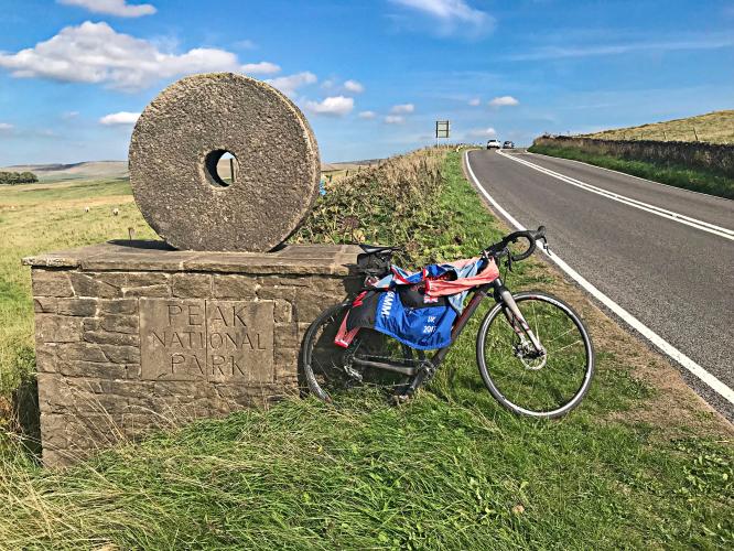
![Cycling Cat & Fiddle, England Cycling Cat & Fiddle, England - stone circular monument along roadway with bike parked in front of it with PJAMM Cycling jersey draped over it, monument says "Peak National Park" and has a hole in the center through which you can see the peak in the distance]()
Peak National Park Monument at km 5[2]
“The Cat & Fiddle is one of the longest climbs in England. It averages 3.2% over 10 km. It is a fairly steady slog all the way to the top, but there are a couple of short sections of downhill. It is steepest when leaving the town of Macclesfield. On leaving town, it is 6% for the first two km. Then it levels off to 3-4%.” https://cyclinguphill.com/100-climbs/cat-fiddle/
The climb begins in the eastern section of Macclesfield (pop. 52,044):
“Macclesfield is a market town and civil parish in Cheshire, England. The population of Macclesfield at the 2011 census was 52,044. A person from Macclesfield is sometimes referred to as a "Maxonian . . .
. . . Macclesfield was granted a borough charter by Earl Ranulf III of Chester, in the early 13th century, and a second charter was granted by the future King Edward I, in 1261. The parish church of All Saints was built in 1278, an extension of a chapel built in approximately 1220.[10]
Macclesfield Castle was a fortified town house built by the dukes of Buckingham in the later Middle Ages.
https://en.wikipedia.org/wiki/Macclesfield

 We've partnered with Sherpa-Map.com to bring you the best route planning tool. With a PRO Membership you can use this climb as a reference when creating your route.

