Cycling Hartside, Melmerby, UK.
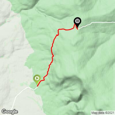
The Hartside climb is a long mild grade along a the fairly busy A686 just north of Melmerby at the western edge of North Pennines Area of Outstanding Natural Beauty. The climb averages only 5.3% but at 7.7 kilometers it is in the Top 10 Longest of the 100 Greatest Cycling Climbs. There are excellent views from the top of this climb, including on to Scotland 40 kilometers north.

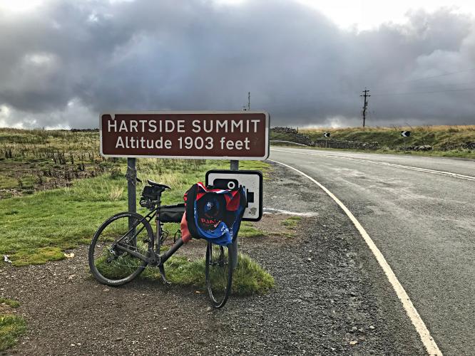
Exceptional views from the Summit (photo bottom right).
The climb may be one of the steadiest grades on the 100 Greatest Cycling Climbs list, never varying more than two percentage points throughout the entire climb.
![]()
We don’t see this unvarying of a grade often.

Views along the climb.
The Hartside Top Cafe had previously been at the Hartside Summit, but as of September 2018 when we made the climb, it had major fire damage and was closed.
Chronicle Live:
“Bikers and cyclists have shared their memories of an iconic cafe which has burned down after years as a well-deserved pit stop for those heading to the Lake District from the North East.
The Hartside Top Cafe, near Alston, went up in flames on Tuesday. The cafe had cult status with bikers and cyclists, who stopped there to admire stunning views of the Lake District while refuelling on tea, coffee and cake after climbing 1904ft to reach Hartside summit” (Full article here).

Before fire.
Photo - Ken Brown

After fire: condition as of September 2018 (fire occurred 6 March 2018).
The climb begins in Melmerby (population ~200) located u Cumbria, England about 9 miles east of Penrith:
“Surrounded by beautiful countryside it sits between the North Pennines with its highest point, Cross Fell to the east and the World Heritage Lake District National Park 10 miles to the west. It is relatively quiet because the area is not as popular with tourists as other parts of Cumbria. It has ample facilities to support visitors who choose to travel outside the Lake District National Park which can sometimes become congested in high season. The River Eden is bridged about 4 miles (6.4 km) away at Langwathby, and Long Meg and Her Daughters, the 3,500-year-old stone circle—the second largest in the country—is nearby at Little Salkeld.
For the purposes of local government Melmerby is within the civil parish of Ousby, informally known as Ousby and Melmerby, in the District of Eden with Penrith at its heart.
History:
Melmerby is supposed to have taken its name from the residence of Máel Muire, a presumed Norse-Gael who lived nearby in the 9th century. The most significant historic buildings surviving in the village today are the 13th century church of St John the Baptist and the Grade II Listed Melmerby Hall, begun as a defensive structure in the early 14th century. A petition received by Edward II between 1320 and 1326 reads:
"John le Denum petitions the King that whereas he has a castle in Cumberland called Melmerby Tower, which could be kept by a dozen men at arms, he has kept it until now and has often been assailed by the Scots to their great loss, and John's lands are so devastated there and elsewhere that he can no longer bear the expense. He craves help in the form of wages or otherwise until times change, because all the country around would suffer great loss peril and loss if it were taken through lack of garrison."
The hall, built from the local red sandstone, was extended in the 17th century and again in the 18th century in a Georgian style. The 20-acre (81,000 m2) grounds include an archery lawn, walled vegetable gardens, a Victorian castle folly and wooded areas. Features inside include a priest hole and a large inglenook fireplace (Melmerby, Cumbria).

Yep - busy highway with no bike lane, so beware.
Simon Warren’s #77 of the Greatest 100 Cycling Climbs in Britain begins in the eastern section of North Pennines Area of Outstanding Natural Beauty. The 770 square mile North Pennines AONB was established as such in 1988 because of its moorland scenery, from centuries of lead-mining and farming. Visitors of this area can expect to see “open heather moores between deep dales, upland rivers, hay meadows and stone-built villages, some of which contain the legacies of a mining and industrial past.” Throughout this area’s history, it has been mind for minerals like coal fluorspar, iron, barytes, lead, witherite, and zinc. This is the second largest of the UK’s 49 AONBs (North Pennines)