![]()
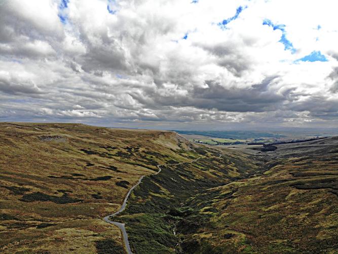
View from the top back down the hill
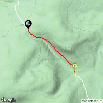
This is a modest and remote climb in the Ribble Valley District of Lancashire County, Northwest England. The climb is surrounded by rolling hills covered in grass. There are rollers through the first 2 (and easiest) kilometers which average 5% - the final kilometer averages 8.8%. This is one of several climbs in the Forest of Bowland Area of Natural Beauty.
![]()
Photo top right - cemetery at 2 kilometers.
There is a cemetary at the 2km mark that is just before the steepest ½ kilometer (10.8%).
At the top of this climb is the The Cross o’Greet:
“To the north of Upper Easington sits the Cross o'Greet, the ancient boundary point and watershed between the medieval lordships of Bowland and Burton-in-Lonsdale, Clitheroe and Hornby; the route up to the Cross across what was anciently called "Gradale" is perhaps one of the most ruggedly beautiful in the Forest.” Wikipedia

Cross o’Greet - Photo Tom Howard

PJAMM at Cross o’Greet
![]()
Steepest ½ kilometer begins at km 2.1 (10.8%)
![]()
“Perched at the highest point of the narrow road that links High Bentham with Slaidburn lies the stone that once held the ancient Cross of Greet. From either side there is plenty of climbing to be had but for the longest ascent, approach the summit from the Slaidburn side.” 100 Greatest Cycling Climbs (Britain).
ClimbingCyclist.com:
“Cross of Greet can be climbed in either direction. If you climb from Slaidburn, apart from a brief section of 10%, it is fairly steady for the first mile, but as you get nearer the top, the climb gets steeper, reaching 13% at its steepest. OVerall, it is a fairly steady climb, never too steep, but climbing a respectable 184m over two miles. The Trough of Bowland is excellent cycling countryside, often the roads are very quiet, the only downside is that it’s often a bit misty up there.
The Cross of Greet takes you over Feltham moor from Slaidburn towards High Bentham. To mark the top of the moor, there is a stone with a hollow in the middle. Legend suggests there was a cross in this spot, but you won’t see any cross these days.
Others have asserted that the hollow in the stone is a plague hole – where washing money in a plague hole would prevent the plague being caught after going from one region to another.
Greet may come from a derivation of Grit – a rocky outcrop nearby. More on Cross of Greet.” More
This climb is in the northeastern section of the Forest of Bowland Area of Natural Beauty
“The Forest of Bowland, also known as the Bowland Fells, is an area of barren gritstone fells, deep valleys and peat moorland, mostly in north-east Lancashire, England with a small part in North Yorkshire (before 1974, some of the area was in the West Riding of Yorkshire). It is a western spur of the Pennines[1] and was once described as the "Switzerland of England".
The Forest of Bowland has been designated an Area of Outstanding Natural Beauty (AONB) since 1964. The Forest of Bowland AONB also includes a detached part known as the Forest of Pendle separated from the main part by the Ribble Valley, and anciently a forest with its own separate history. One of the best-known features of the area is Pendle Hill, which lies in Pendle Forest. There are more than 500 listed buildings and 18 scheduled monuments within the AONB.
Bowland survives as the north-western remainder of the ancient wilderness that once stretched over a huge part of England, encompassing the Forest of Bowland, Sherwood Forest (Nottinghamshire), the New Forest (Hampshire) and Savernake Forest (Wiltshire). While the Trough of Bowland (the valley and high pass connecting the Wyre (at Marshaw) and Langden Brook and dividing the upland core of Bowland into two main blocks) represents the area, to many, on account of its popularity, it is in fact only a small part of the wider Forest of Bowland area.
The hills on the western side of the Forest of Bowland attract walkers from Lancaster and the surrounding area. Overlooking Lancaster is Clougha Pike, the western-most hill. The hills form a large horseshoe shape with its open end facing west. Clockwise from Lancaster the hills are Clougha Pike (413 m or 1,355 ft), Grit Fell (468 m or 1,535 ft), Ward's Stone (561 m or 1,841 ft), Wolfhole Crag (527 m or 1,729 ft), White Hill (544 m or 1,785 ft), Whins Brow (476 m or 1,562 ft), Totridge (496 m or 1,627 ft), Parlick (432 m or 1,417 ft), Fair Snape Fell (510 m or 1,670 ft), Bleasdale Moor (429 m or 1,407 ft), and Hawthornthwaite Fell (478 m or 1,568 ft). Considerable areas of the Bowland fells were used for military training during the Second World War, and there are still unexploded bombs in some areas.
The area contains the geographic centre of Great Britain which is close to the Whitendale Hanging Stones, around four miles (6 km) north of Dunsop Bridge. The historical extent of Bowland Forest is divided into two large administrative townships, Great Bowland (Bowland Forest High and Bowland Forest Low) and Little Bowland (Bowland-with-Leagram), but the modern-day AONB covers a much larger area.” Wikipedia - Forest of Bowland
![]()
St. Andrew's Church, Slaidburn - Photo - Chris Ecclestone
The climb is remote, beginning nearly 10 kilometers from the nearest village/town - Slaidburn, Lancashire County:
“Slaidburn (/ˈslɛdbərn/) is a village and civil parish within the Ribble Valley district of Lancashire, England. The parish covers just over 5,000 acres of the Forest of Bowland.
Historically in the West Riding of Yorkshire, Slaidburn lies near the head of the River Hodder and Stocks Reservoir, both within the Forest of Bowland, an Area of Outstanding Natural Beauty. Farming is still a major employer, but the area attracts tourists; for walking in particular. The civil parish of Slaidburn shares a parish council with Easington, a rural parish to the north of Slaidburn.
According to the 2001 census, the parish had a population of 288, however the United Kingdom Census 2011 grouped the parish with Easington (2001 pop. 52), giving a total of 351.
The parish church of St Andrew has a superb Jacobean screen and a fine Georgian pulpit. The brass band composer William Rimmer (1862–1936) composed the now-popular march, named Slaidburn after the village, for the Slaidburn Silver Band. A new village hall has opened to much fanfare and is being well used.[5] There is a local pub, the Hark to Bounty, which upstairs houses the ancient halmote or courthouse of the Manor of Slaidburn.
History:
From early times, the Manor of Slaidburn formed part of the ancient Lordship of Bowland, being held in demesne from the second half of the 14th century.
The Lordship of Bowland comprised a royal forest and a liberty of ten manors spanning eight townships and four parishes and covered an area of almost 300 square miles (800 km2) on the historic borders of Lancashire and Yorkshire. The manors within the liberty were Slaidburn (Newton-in-Bowland, West Bradford, Grindleton), Knowlmere, Waddington, Easington, Bashall, Mitton, Withgill (Crook), Leagram (Bowland-with-Leagram), Hammerton and Dunnow (Battersby).
There was a major manorial reorganisation of Bowland in the second half of the 14th century, which may have been precipitated by a fall in population caused by the Black Death (1348–50) but was probably also a consequence of the absorption of Bowland into the Duchy of Lancaster. Among other changes, this saw Newton subsumed into the demesne of Slaidburn and the manorial caput shift from Grindleton to Slaidburn.
Two of the Lord of Bowland's mesne manors – Battersby (Dunnow) and Knowlmere – fell within the bounds of the township of Newton but did not become part of the demesne of Slaidburn. See Newton-in-Bowland for further information.
According to a leading local historian, the historic Manor and Liberty of Slaidburn covered a wide area, not equivalent to the Slaidburn parish boundaries, but comprising the villages and town fields of Slaidburn and Newton-in-Bowland, including Ingbreak, a town field to the west of Slaidburn village; Raw Moor, part of the enclosed land of 1619 north of Slaidburn village in the Croasdale area; Brunghill Moor, Burn Moor and Dunsop, also enclosed in 1619 and near Back Lane and Burn Hill; Champion, also enclosed in 1619 and to the east of Slaidburn village; Woodhouse, to the north west of Slaidburn village; Youlstone Wood, also enclosed in 1619, and to the south of Newton village; and most of West Bradford and Grindleton villages and their town fields.
Title to the Manor and Liberty of Slaidburn, West Bradford and Grindleton, including the township of Newton-in-Bowland, was bought by Tory MP, Ralph Assheton, later first Baron Clitheroe, in 1950. In 1977, his second son, the Hon Nicholas Assheton, was granted title. Since 2003, the Lord of the Manor and Liberty of Slaidburn has been Thomas Assheton, son of the Hon Nicholas Assheton and nephew of the second Baron Clitheroe. Steward to the Manor of Slaidburn is Michael Parkinson. Parkinson, a land agent and chartered surveyor, also serves the Lord of Bowland as his Chief Steward of the Forest of Bowland.” Wikipedia - Slaidburn