
33.8
PDI
18.9 mi
DISTANCE
5,830 ft
GAINED
5.6 %
AVG. GRADE
FULL CLIMB STATS
INTRO
Hoya de la Mora is the road up to Sierra Nevada's ski station above Granada, climbing 18.91 miles and 5,830 feet at a 5.57% average grade from just west of Monachil to the barrier at the edge of the Pradollano resort, around 2,460 meters (8,090 feet). It's currently the #212 hardest climb in the world.
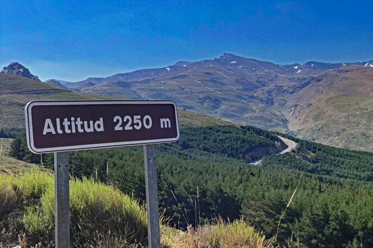
The grade itself is manageable throughout - the steepest full mile still only averages 10.5% - but altitude does the real work here. The final third of the climb sits above 2,000 meters, where thinner air makes even moderate pitches feel harder than the numbers suggest. The road runs through Sierra Nevada National Park almost the entire way, switchbacking up open, treeless slopes with sweeping views back over Granada and, on clear days, out toward the Mediterranean.
This climb hosted its first Vuelta a Espana summit finish in 2017, when Stage 15 ended near the ski station at roughly 2,510 meters - the highest finish the Vuelta has used in the Sierra Nevada. Pradollano itself is Spain's southernmost ski resort and has hosted the country's national ski championships for decades.
Above the barrier at Hoya de la Mora, the road continues as a gated, motor-traffic-closed extension toward Pico Veleta, one of the highest paved roads in Europe - a natural add-on for riders who want to keep going past this climb's finish.
Snow typically closes the upper kilometers from late autumn into spring, so this is fundamentally a late-spring-through-autumn ride above the tree line.
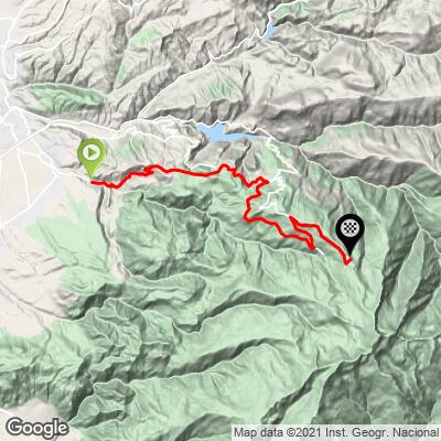
PLAN YOUR ROUTE
 We've partnered with Sherpa-Map.com to bring you the best route planning tool. With a PRO Membership you can use this climb as a reference when creating your route.
 Hoya de la Mora averages 5.57% over 18.91 miles, gaining 5,830 feet in a long, steady grind rather than a series of hard ramps. The steepest 100 yards touches 15.2%, the steepest quarter-mile 13.3%, and even the steepest full mile only averages 10.5% - sustained double-digit pitches are rare on this one.
The final five miles ease to a 7.9% average as the road opens onto the high plateau near the ski station. Most of the real difficulty here comes from length and altitude rather than gradient: the last third of the climb sits above 2,000 meters, where the thinner air makes even the moderate sections feel considerably harder than the profile alone suggests.
Roadway: The road is paved the entire way from Monachil to the barrier at Hoya de la Mora and has been in good condition through Sierra Nevada National Park, though the final kilometers can show winter frost damage before spring repairs. Snow and ice close the upper road for much of the winter and into spring - check Sierra Nevada's resort and road-status pages before planning a climb outside summer.
Traffic: Traffic is light to moderate through Monachil and picks up on the lower switchbacks, where local and tourist traffic to the ski resort mixes with cyclists. It thins out considerably once the road enters the national park and is minimal for the final few miles into Pradollano.
Parking: Monachil is a small town at the base of the climb with a handful of cafes if you want to start there, though many riders instead stage from Cenes de la Vega or Granada itself, since this is one of several roads up to the ski station. Pradollano has extensive resort parking near the top, and the car park at the Hoya de la Mora barrier itself is the standard turnaround point for the closed upper road toward Pico Veleta.
Provisions: There's nothing between Monachil and the Pradollano ski resort near the top, so carry enough water and food for the entire climb - shade is scarce above the tree line, especially in summer heat. Pradollano has restaurants, cafes, and a supermarket if you need to refuel before the descent or before continuing on toward Pico Veleta.
Before heading out on any cycling adventure check out our Things to Bring on a Cycling Trip and use our interactive check list to ensure you don't forget anything.
Granada, about 30 minutes below the base of the climb, is the natural place to stay - the Alhambra, the Albaicin quarter, and the city's tapas culture are worth a day or two on either side of the ride. Pradollano doubles as a summer hiking and mountain-biking base once the snow clears, with a small village of shops and restaurants at the top.
Riders who want more after reaching the barrier at Hoya de la Mora can continue - on foot, or by checking current access - up the closed road toward Pico Veleta, one of the highest paved roads in Europe. Conditions at this altitude can differ sharply from Granada below, so check current conditions with our Weather tool before heading up outside summer.
ROUTE MAP
MEMBER RATING
CURRENT WEATHER
PJAMM TRIPS ADVENTURE STARTER BUNDLES
Check out PJAMM Adventure's prepackaged (self-guided) cycling trips. They will help you plan, document and conquer your next adventure.
NEARBY CLIMBS (0) RADIAL PROXIMITY
FROM No Climbs Found
MEMBER REVIEWS & COMMENTS
Let us know what you thought of this climb. Signup for our FREE membership to write a review or post a comment.
Already have an account?
LOG IN HERE
