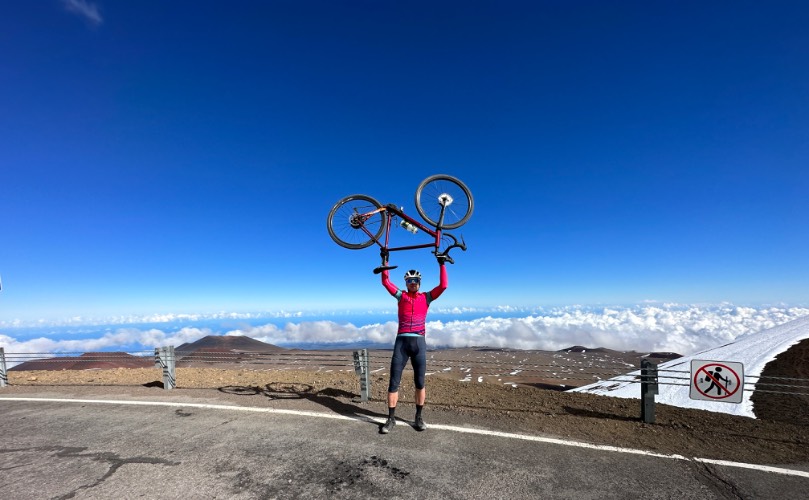
95.7
PDI
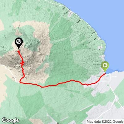
42.5 mi
DISTANCE
13,755 ft
GAINED
6.1 %
AVG. GRADE
FULL CLIMB STATS
INTRO
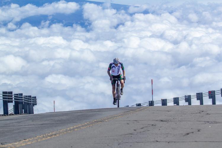
This is hands down and by far the hardest bike climb in the world. The climb begins with the waves of the Pacific Ocean lapping at the shore behind us and ends 42 miles later, 13,803' above sea level at Mauna Kea Summit. In those 42 miles we descend less than 100'. We travel through five climate zones -- from the lush rainforest environment of Hilo, Hawaii to the lunar landscape that surrounds us the final 10 miles of the climb. At the top, you will have 42% less oxygen available as you climb the final miles at grades reaching 16%. Climb above the clouds to the top of the bike climbing world. This is the "Biggest Climb" you can ever do on Strava (Strava Mauna Kea Segment) . . . but, see our dear friend Erwan Treguier's tale of Mauna Kea + Mauna Loa . . . on the same day!!
Our Big Island guided tour App is accessed below.
PLAN YOUR ROUTE
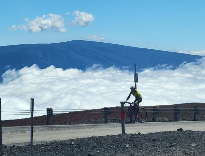
It's all about altitude and gradient on Mauna Kea. There is 42% less oxygen at the summit than start (3% less each 1000'). The 14.5 miles on Mauna Kea Access Road from 6,588' to the summit at 13,842' averages 9.5% (this segment alone qualifies as the #4 hardest world bike climb).
Average grade for 42.6 miles is 6.1%. We climb 13,863' and descend only 98'. 46% (19.6 miles) of the climb is at 0-5%, 37% (15.6 miles) is at 5-10%, 12% (5.2 miles) is at 10-15%, 3% (1.2 miles) is at 15-20%, and a fraction is above 20%. The steepest quarter-mile is 16.5% and steepest continuous mile is 14%
See more details and tools regarding this climb's grade via the Profile Tool button.
Roadway: The roadway is in excellent condition but there are 4.7 miles of gravel and sand to contend with just past the visitor center.
Traffic: For the first nine miles and the final fourteen miles, traffic is not a problem. However, 20 miles on Highway 200 (Saddle Road) can be harrowing with traffic whizzing by often above the posted 55 mph, including commercial trucks traveling the primary east-west traffic artery across the island. There is always a very wide shoulder and deep rumble strips (you\'ll know what I mean if you ride over them on your bike) that separate the "slow" highway lane from the shoulder. This is a tough section for the traffic averse.
Parking: There is street parking near the start, or parking on 301 Kamehameha Ave near the start which also is home to the Hilo Visitor Center (Map Street View).
Clothing: We have been snowed on atop Mauna Kea. It will almost always be around 70 degrees in Hilo and probably raining. The temperature nearly 14,000' higher will be quite different, particularly during the winter. Review the PJAMM weather tool for summit forecast before you begin your ride.
Cycling Gear: You either need to bring a gravel bike with 40mm tires or mountain bike to swap to for the 4.7 mile sand-gravel section. Bring MTB shoes for hike-a-bike on the impossibly steep and sandy portions.
4WD: Required above the Visitor Center. Use SAG/photographer Christian James (christianjamesphoto@gmail.com), or rent a bigger 2WD vehicle for SAG to MK Visitor Center and one of the Jeep 4WD rentals on the Big Island for the segment above the VC.
Provisions: There are sandwiches, chips, water, Gatorade, and the like at VC.
Before heading out on any cycling adventure check out our Things to Bring on a Cycling Trip and use our interactive check list to ensure you don't forget anything.
Booking your travels through one of these links helps us continue to bring you awesome info on climbing and cycling. Thank you!
Mauna Kea is the hardest bike climb in the world. If you are interested in traveling to The Island of Hawaii for a cycling adventure, be sure to consider PJAMM’s travel app and our Hawaii: The Big Island Tour. The app and Big Island trip page feature: navigation, sharing your trip real time, tracking trip participants, blogging, an itinerary to ensure you're on time for all trip events, and PJAMM's choices for things like points of interest, cycling climbs, and routes - all you need to ensure your trip goes smoothly. Our travel app also acts as a digital photo album to use on your computer, tablet, smart TV, and other devices.
ROUTE MAP
MEMBER RATING
CURRENT WEATHER
PJAMM TRIPS ADVENTURE STARTER BUNDLES
Check out PJAMM Adventure's prepackaged (self-guided) cycling trips. They will help you plan, document and conquer your next adventure.
NEARBY CLIMBS (0) RADIAL PROXIMITY
FROM No Climbs Found
MEMBER REVIEWS & COMMENTS
Let us know what you thought of this climb. Signup for our FREE membership to write a review or post a comment.
Already have an account?
LOG IN HERE
georgegresham
Did the ride on Jan 1, 2026. Started about 615am. Like others, I found the ride to the Access Road to be pretty manageable with great pavement and steady grades. Traffic was not a problem. The first portion of the access road was the same but I found the grades on pavement from about 1.5 miles before the visitor center and all of the pavement after the gravel to be very, very challenging. Yes, more challenging than the gravel. I did need to walk a short section of the gravel but overall, I didn't find the gravel to be the primary challenge. Took me just under 5 hours to the visitor center and 7:50 total to the summit. I road my Canyon Grail with 1x40/44 and 40mm tires the whole way. Did about 60 grams of gels per hour, 6 bottles with Tailwind, two large cookies. The only thing I would change is the gearing.
jfarmer191
I completed the Mauna Kea ride on 6 Oct '25, starting before sunrise in Hilo and finishing before sunset at the top. I'm 57 and did a lot of preparation rides this year on 10%+ gradient and in the few weeks before the MK ride, at altitude as well. I used my gravel bike with 28 mm tires on the pavement and switched to wheels with 38 mm gravel tires for the gravel section. I used a 36/52 climbing gear. My son rode along the route in a 4x4, with us meeting up a few times to reload on food and water. The weather was perfect that day with relatively clear skies, no rain, and generally light winds. The gravel is certainly the most unique challenge given that there are 4-5 sections with 15% class grade and a lot of loose gravel/sand along the way. Once through the gravel (round 14 of 15!) you have about 3 more miles of steep pavement (plenty of it at 15%) to reach the summit. Awesome ride, very challenging and a great accomplishment for all who ride it!
JustKeepClimbinb
I did Mauna Kea in October 2025. I rode my gravel bike with road tires and then switched wheels at the Visitor Center to wheels with gravel tires. My gearing was 38 x 52. A friend drove a 4x4 along with food, water, etc. I was really lucky with weather. It wasn’t too hot at the start and it wasn’t too cold at the end. There wasn’t much wind, either.
Hilo to Mauna Kea Access Road - I started at the beach at 6am. My main goal was to not go too hard so I kept an eye on my power and heart rate. This part was not that hard and I felt good at the turn.
To the Visitor Center - The road picks up here but with the low gearing and a slow pace it wasn’t too bad. I felt fine as I pulled in. I took a break here to swap to my wheels with gravel tires (Cinturato Gravel M 650b x 50mm). I also had some food and filled out the form.
JustKeepClimbinb
Gravel Section - The road has a lot of loose dirt so I just focused on finding a good line. This part went well until the last steep section. I spun my wheel and had to clip out. Then I couldn’t get going again so I had to walk a little bit until I could pedal again.
To the Top - This was definitely hard. I wasn’t having any problem with the elevation (altitude sickness, headaches, etc.). But now I just didn’t have a lot of power or sustained power. I had to paperboy a lot of it and take some breaks. It was mentally tough seeing how far it was to go and how much was steep gradient. But I kept plugging away and made it. I felt good and tired but not destroyed.
It felt great at the top and it was nice to have my friend with me. I’m not the strongest cyclist but I have a lot of endurance and can ride all day if I pace myself. I’ve done a lot of climbing and gravel so that really helped mentally.
JustKeepClimbinb
My advice is to do a lot of long rides and make sure you have a good nutrition plan. Have low gearing and do some steep hills just so you know you can do them. But overall fitness is probably the most important thing. There are no hills where I live so I focused on doing long rides and some interval training.
ArdOostra


Ard Oostra: On Monday morning 16th June 2025, a little after 6 am, after the traditional dip of the wheel in the sea, i started in Hilo for the 70 kms long climb to Mauna Kea, the « hardest climb in the world »
After a light rainshower, i was greeted by a colorful sunrise above the ocean. The first kilometers pass through still quiet Hilo and then on to the scenic “old saddle road”. Gradients are mild apart from some short steeper sections. Starting with some 18 C the temperature drops to 12-15 C while I ascend to the intersection with the Saddle road highway at some 600m altitude. Once the sun comes through the clouds it warms up again despite the higher altitudes
For the whole ride I was accompanied by Christian James (photographer) and his wife (driver and medical assistance if needed), they are an excellent support team.
The ride over the (shoulder of the fairly busy) saddle road until the intersection with the Mauna Kea access road (1900 m altitude) is a long stretch, but not ste
ArdOostra
I got lucky because it didn’t rain and there even was a little tailwind in the last kilometers before the right turn to the Mauna Kea access road. Some time to enjoy the view on the disappearing clouds deeper behind me and the stunning views on the Mauna Kea mountain closing in. I made two stops between the start in Hilo and the visitors center to have some food and fill up my bottle. Once I entered the access road, the gradients quickly got steeper and I had a pretty strong side / head wind until a couple of kilometers before the visitor center. Some 45 kms done and 2700 m gained, so far so good.
After a break at the visitors center
I got clearance from the park ranger and could continue to the much feared gravel section. Christian brought a MTB with his car upon my request but I decided at the moment itself to ride the 9km gravel section (and 800 m altitude gain) with my road bike and 28mm all season tires
I managed to ride most of the gravel section, had to walk some of the steeper
ArdOostra
parts with looser gravel. At one moment I fell of my bike, because my rear wheel slipped and I couldn’t get out of the pedal in time.
The gravel section definitely is hard, also because one feels the decreased oxygen levels above 3000m altitude
I made a short stop where the gravel section ended. Once on the asphalt again there is a feeling of relief but that didn’t last long when I saw how steep the road becomes. The steep gradient, thin air, strong sun and energy already spent make it very tough to stay on the bike. I wished I had had a lower gear. But the ultimate goal is the summit, the telescopes at 4200m altitude, of course, that’s why I came to Hawaii Big Island and that’s what I trained for in the previous months. So, I went for it and was welcomed on the summit by the team. An emotional moment to reach Mauna Kea summit in the PJAMM Hawaii jersey (thanks John!) and enjoy the stunning views on the volcanic landscapes and world below
ArdOostra
It’s definitely worth the investment. Greatly recommended to well prepared riders.
Ard Oostra (Nld)
Montreux, Switzerland
poxpower

https://www.strava.com/activities/12910367844
Went to Hawaii just for this bucket list item! The gravel and paved section after are just brutal. Had a support car give me my running shoes to do the gravel since I only had a road bike. Coming from sea level, the altitude wrecked me completely. Need much better gearing than what I had. ( 34/30?)
climbernf
I completed this crazy climb in early October 2024 from Hilo. Started 30 minutes before sunrise.The temperature at the top only required a wind breaker.
Brought my bike with Sugino 44/27 - 11/40. Could have used even more!
Bikeworks Kona has great mechanics and is a good place to rent bikes from. They helped put my bike together, and fixed a bent derailer hanger during shipping.
There is a public bathroom and water fountain at the Kaumana Caves.
Every 1000' climbed, I took a break and stretched.
Many say 4WD like a Jeep Wrangler is required.
They allowed our AWD Ford Expedition SUV to proceed. You need a AWD with a low mode, so you do not burn the brakes out on the way down. They mentioned that a Ford Escape could not handle it.
Big shout out to the wife: Spam Musubi and a big gulp from 7-11 were a welcome change from bars and electrolytes!
Many folks come up to the visitor's center to see the stars. That evening it was cancelled due to fog. Weather changes quickly here.
ColombiaCycling
We have done MaunaKea and some of our clients too, but after them I have to admit that the hardest between MaunaKea
and Letras x Sifón in Colombia this one is much harder by far. Is longer, higher but the most important more enjoyable, the variety of landscapes, the villages fully alive and colorful that you pass, the weather, and of course the days after and before the climb
Jared


Did this ride 2/17/24
I drove over from Kona at 4:30 in the morning to Hilo with my wife and dropped a food bag at the turn off to Mauna Kea. Wouldn’t have support on ride so it worked great.
Full rain in Hilo but warm. Easy climb all the way to turn. Mellow in my opinion it could be hard though with headwinds. The climb to the visitor center was more aggressive, and definitely steep at points. When I arrived at the visitor center, I needed to fill out a card showing my information so they could keep track of me going up to the top of the mountain and back down. The dirt road was loose at parts, but rideable on a mountain bike, which I took my bike packing bike on this ride, which is a hard tail Specialized
After the dirt road ended, you had about four or so miles to the top on one of the steepest paved Roads I’ve ever rode . Had to walk the last mile or so to the observatory because of the steepness and the Highwinds. Make sure you’ve got good fresh disc brakes to come down!
openfancy

While my girlfriend was competing in the Ironman, I embarked on an adventure of my own. I started at A-bay, which turned out to be a tougher version of this climb than I expected. The route began on a straightforward highway-like road but transformed dramatically after a left turn onto Mauna Kea road, about four hours in. Throughout this journey, I had incredible support from Hawaii Epic Cycling. They not only provided transport from my hotel to the start but also stayed with me for the entire ride, offering water, snacks, and helpful tips. Particularly memorable was their support on the ebike during the gravel section, where they also snapped an epic photo of the experience. Their presence truly enhanced my adventure, and I wholeheartedly recommend them to any cyclist looking for an unforgettable ride.
ineptsidekick
Amazing ride, by far the most difficult section is the gravel, possible on CX tires with the right gearing.
I rode on 34 mm semi slicks (WTB byways) and had 22/34 gearing and I would have benefitted from lower.
Don't forget that your sustained power is much lower at elevation, plan for lower gearing accordingly.
I highly recommend hiring Christian James Photo to help you. They were very friendly, provided me with great SAG service for the day and amazing pictures that I will keep forever.
Swift06
Thanks for the info! How many times did you need to stop for water? Did you rent or bring a bicycle?
ineptsidekick
I brought a cx bicycle that I installed mountain bike cranks on, to allow for lower gearing. The gravel section was very steep and extremely loose, you need way lower gears then you think or wide tires. Christian Jame's SAG service had refueling available frequently (30min to 60min range). I probably refilled my bottle 5 times, but that will be highly dependent on weather, the day i went was warm, mostly overcast for the first half of the trip.
Webbcorp


https://www.strava.com/activities/8447277079
Monica


Successful 1st attempt from Hilo on 11/17/22, 9h 7m on Mauna Kea Strava segment. Rented gravel bike (Giant Revolt) from Bikeworks Beach & Sports in Waikoloa; brought my own 11-40 cassette (bike came with 11-34 cassette and 48/31T crank) and chain to have extra low gears. Very happy with this setup, also had decent 38mm tires (Specialized Sawtooth). Checked wind speed and road status at http://mkwc.ifa.hawaii.edu/forecast/mko/index.cgi beforehand, but there is no reliable forecast. My husband drove a support van to the Visitor Center, and then rode along on an eMTB to the summit with a backpack of extra clothing for the descent. Never had to walk, but took the tire pressure way down for traction on the gravel. After reading other trip reports, I thought the gravel was not too bad; the road is very wide so you can pick your line. The final 3 miles on asphalt were daunting, with that final brutal switchback forever in view. After summiting, we rode back to the Visitor Center to our van.
bgersak

This 09/17/2022 was my second attempt to reach the summit. First one was one week earlier on 09/10/2022. I had just road bike at that time (50/34 - 11/36) and the gravel road from VS was too much for it. Tried my best but ended about 2 miles from the summit. One week later without support car I took my MTB (36/24 - 11/36). It was good decision for the gravel, not so good for the paved road. I walked last half a mile on the gravel, from the sign - Ice age -which is brutal because of the 15% but mostly because of badly damaged road and high altitude. The weather was perfect, no inversion clouds and fog below. Three miles before VS the chain got trapped between last cog and the wheel. I realized I cannot shift anymore. Tried to fix this at VS, rangers were very friendly, Mike especially, but they had no appropriate tools. So I went on with just one gear. On the way down full suspension on gravel was perfect. EPIC CLIMB, I recommend two bikes, one for the paved road and one for the gravel.
Pknavr


8/5/22 - Left Hilo before sunrise to get ahead of the afternoon snow forecast at the summit- clouds rolled in as I started down (in support vehicle- would have been drenched and miserable otherwise). Switched wheels to 31/42 gear ratio with 42mm tires at the VC using the same Diverge frame. Last half mile of the gravel at sustained 15+% was the hardest part of the entire climb. Altitude really sapped the power above 11,000 ft; I conserved effort on the lower part of the climb, but ultimately couldn't burn any matches at altitude when I wanted them. Epic climb.
Chaddad

Climbed on Sept 1, 2022. A perfect day of cycling for me. Cool and overcast in Hilo, a little sun about half-way to the access road, then a tailwind up to the turn. I rode through the clouds between 7 and 8,000 feet but then it was clear skies and pleasant temps all the way to the summit.
I brought my own bike built for this kind of ride. It's a no-name chinese carbon mtb frame, built up as an all-road/gravel bike, 40x24 and 11-42. Front Furious Fred/Rear Speedking. Aerobars for the flats. I rode my target watts and arrived at 10,000 feet feeling great. Which was good because the last mile of the gravel was steep, loose and washboarded. I was pretty relieved when that was over only to have a headwind on the super steep grind to the 2nd to last turn. My advice to add: no gear is too low when the road is this steep, this high up the mountain. I never had to walk or paper-boy.Big thanks to my wife, who supported me for the last half of the ride (and the 25 years before that).
cfgrogan

Attempted on 4/6/2022 from Waikoloa Beach. First 17 miles had a decent cross headwind which made for slow going. Steep pitches start on the access road and I was happy I had the proper gearing on a rented Cervelo Aspero (30 front 34 back). Made it to the visitor center in another 90 minutes or so despite feeling like I was barely moving. Once at the VC, what looked like fog was clearly rolling in but they let me continue up the gravel part. Made it 2.5 miles or so up the gravel (only had to walk once on a very steep loose section) before a ranger drove past and told me they were closing the road and I needed to turn around. It started pouring ice rain and my goretex jacket was still in the support vehicle that now couldn't come up the road with the closure. Unfortunately turned around at 10,600ft :( The 38c tires on the gravel bike came in handy, might be able to do it on a 28c road bike but would be tough and probably slip a ton/require walking.
bbypy
'Rode' this 6/23/21 from Waikoloa Beach unassisted. Ritchey breakaway, 30C, 50/34 X 11-34, 3L camelbak (12 lbs full). Without support, go Kona side as you can pit stop at the Kahehe rest area off Inouye Hwy. Take Old Saddle Rd - much quieter and absolutely beautiful - best part of whole ride imo. Phone coverage is good all the way so you can call for bail-out. Part above VC at 9000ft is as bad as most ppl say. Probably doable on road tires if you are >4-5 W/kg FTP. I'm not - ergo did 'some' high altitude bike hiking. Normal-ish riders need >35c tires + MTB gearing imo. Above 11000ft, altitude really hit and could not push 34/34 @ >10%. Don't know if it was just me, me that day, or something physiologically fundamental. Been up that high before and not had problems. Have small rain jacket for descent. Sort of sketch dodging tour vehicles coming up gravel part and got wet below VC to Hwy. Weather tends to come in late day. Would not want to descend Hwy to Hilo.
caedwards


Completed 5/19/2021
Gear: Fuji Sportif 2.0LE | Shimano Tiagra | Compact Crank 50-34t | 11t-36t cassette (w/ Wolf Tooth Road Link) | 35mm Clement XPlor Ush tires.
Such a sufferfest. First 7 miles from Hilo was great. Then a steady Hawaiian rain from mile 7-22ish. Fortunately it was warm rain and I had a rain jacket. From Mauna Kea Access Road to finish the weather was perfect - sunny and 50-60ºF. The Pjamm summary is spot on: it only gets increasingly more difficult from Saddle Rd to the summit. Gravel section was near impossible - sand/gravel mix. Walked a good portion of it. From end of gravel to summit is still brutally steep, requiring plenty of breaks to breathe (despite my living at elevation in Denver). The last mile has a few easier spots which provide just enough hope to finish out the climb.
I was self-supported from Hilo to Access Road. Had support vehicle (i.e. family) for food/water from Saddle Rd to Summit.
Thanks to PJamm for all the great info and inspiration!
lowestgearpossible


If you love climbing on a bike, this is the most you could probably get, from Waikoloa Village Resorts to summit it's 85km almost continuous climb. Gravel section didn't feel as bad as others posted, but the 3mi after the gravel is the hardest sucker I've ever climbed. Seriously, it takes everything out of you. PERFECT
lowestgearpossible


If you want to make it not only a long climb but also a long ride, you can start at Waikoloa Village. That gives you 53 miles and 4300+m to the summit. Best ride ever, incredibly demanding, 67 finishers on STRAVA as of May 2021.
TiesArts
Once in a lifetime! The last part from above Visitors center is hell! Loosely lava gravel and last 7km altitude impact, postman technique is required. The view at the summit is magnificent!!!


