![IMG_2099.JPG]()
Cycling Shirley Meadows: a challenging Top US 100 bike climb in the southern Sierras.
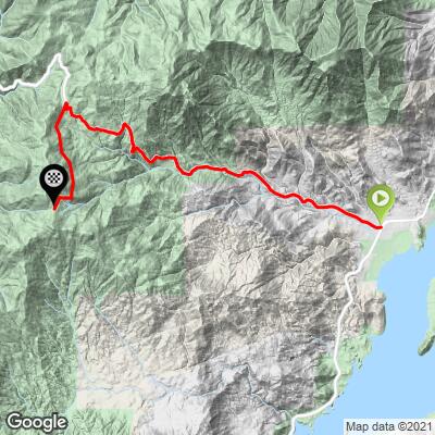
Ride 9.9 miles, gaining 4,255’ to 6,786’ at 7.9% average grade.
Shirley Meadows bike climb is a serious climb (#29 U.S.) in the southern Sierra Nevada Mountain Range in California at Sequoia National Forest. The average grade for the entire 9.9 mile climb is 7.9%, and there are a couple of mile stretches in double figures, with a 12% average grade for one mile beginning at mile 4.3. Top U.S. climbs within 75 miles of this climb are: #13 Sherman Pass at 24 miles, #33 Nine Mile Canyon at 67 miles, #69 Portuguese Pass at 26 miles, and #107 Breckenridge Road at 19 miles. The climb ends at the Alta Sierra Ski Resort & Terrain Park. We enter Sequoia National Forest at Mile 3, but the forest does not really start in earnest until around Mile 6.
See also Shirley Meadows West.
![IMG_2099.JPG]()
The bike climb begins in Wofford Heights and we enter Sequoia National Forest at Mile 3.
“The east side of Shirley Meadows along Route 155 near Isabella Lake is a very difficult climb along a highly variable grade that ends at a ski area. A bit isolated, it includes one of the most difficult five-mile stretches of climbing in the United States along multiple double-digit grade ramps. All that said, please be prepared before you tackle this one as it is one of the most difficult climbs in the country and some think it may be the most difficult in California.
![]()
The climb begins in the small town of Wofford Heights and there is a short stretch of double digit grade immediately to get you ready for the torture to come. Soon the slope eases as you continue west. There are a few homes along the way over this opening stretch and tree cover generally increases as you climb the hill. Little traffic most days, particularly once you get a mile or so from town can make for a pleasant climb (if climbing at his slope can be considered pleasant). Just over one mile into the ascent however the grade rears up steeply through twisty turns in places and is variably steep for the next 5 miles. This section averages almost 10% grade and is one of the most difficult in the United States over this distance and is the key to a successful summit of the east side of Shirley Meadows. A short straight stretch contains the maximum grade on the hill that approaches 20%. After this section the roadway continues to be variably steep for several miles and contains multiple tight turns. Towards the top you encounter some mountain homes in the community of Alta Sierra and a few short descents as the slope eases. At mile 7.5 you reach Greenhorn Summit. Statistics to this point are 7.5 miles at 8.6% average grade; very similar to Whiteface Mountain in New York and the famous l’Alp d’Huez in France. Turn left here on Rancheria Road where the grade eases further. This final section is fairly steady and through thick trees and the listed climb ends at a large parking lot for a ski area. As mentioned, some believe this is the most difficult climb in the Golden State but regardless of its placing within the state it is certainly one of the most difficult you will encounter in the U.S.
This side of Shirley Meadows is more steep and almost as long as the Tourmalet, and essentially statistically identical to Plateau de Beille, two of the most famous and difficult climbs used regularly in the Tour de France. This hill is a challenging in places descent so watch the multiple blind curves heading down as the steep grade will generate speed in places. The west side of Shirley Meadows is a long and mostly shallow climb from Woody, CA...” (This quote is presented with the approval of John Summerson, from his book, The Complete Guide to Climbing (by Bike), 2nd Edition, pg. 152.)
![IMG_2104.JPG]()
Strava member J. Wolfe of San Luis Obispo describes the climb: "If you're talking about the ride as a whole, it is unrelentingly steep, and felt decidedly more brutal than, say, the longer Whitney Portal. The beginning is dry, brown and residential - and carries some traffic, which is a little challenging considering the road's twisty profile & narrow shoulder. However, with the rapid elevation gain, the setting changes to a more alpine feel with beautiful hardwoods. At the top of the pass you take a left toward the ski area (Rancheria Road) and proceed through a dense, stunningly gorgeous forest of massive trees with peekaboo views down a beautiful canyon flanked by impressive mountains. This section is short (2-3 miles) but amazing for its remoteness. You won't see a soul. The ride ends at a tiny ski area (called Alta Sierra) which has seen better days. My advice for amateurs like myself: pack a granny cassette or be prepared to get out of the saddle.”
All right, we at PJAMM have now climbed this monster! Wow -- you absolutely get more bang for your climbing buck on this baby than on most other climbs. We liken the Shirley Meadows bike climb to Utah’s Powder Mountain (#23), the last four miles of which are 12.1%. While not quite reaching the Powder Mountain quad-popping 12.1%, Shirley Meadows stands tall with 10.2% average grade from miles 1.8 to 5.8 (11.4 from miles 4.0 - 5.5). Surprisingly, but perhaps a testament to the slightly “outlier” status of this climb, there was no Strava segment for the entire climb until we created our own (see Veloviewer, below).
![IMG_2106.JPG]()
That is a very steep road that will challenge the best climbers.
![IMG_2125.JPG]()
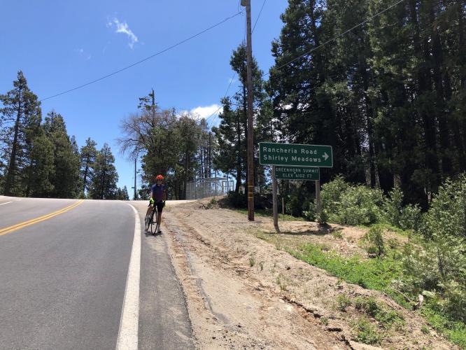
While we are on lightly travelled Highway 155 for the first 7.65 miles, the final two miles along Rancheria Road to Alta Sierra Ski Resort were new as of July 2015, and in excellent shape with minimal to no traffic.
![IMG_2134.JPG]()
Signs say Shirley Meadows, but the Ski Resort and internet say Alta Sierra Ski Resort.
![IMG_2138.JPG]()
![]()
Finish
Thank you Lisa Irizarry!!
The descent is very fast and you will pick up speed quickly as you travel down Highway 155. There are some of the fastest descent stretches in the country along this road.
Roadway Surface and Traffic Report: Traffic is light and the road is in excellent condition. Most areas along the route do not have much shoulder, but minimal traffic mitigates that problem.