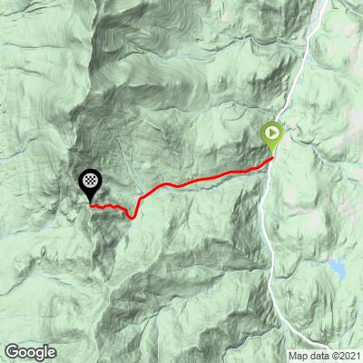
Lincoln Gap East Bike Climb - PJAMM Cycling

2.9
FIETS
4.1 mi
DISTANCE
1,440 ft
GAINED
6.6 %
AVG. GRADE

FULL CLIMB STATS

INTRO

This is a peaceful climb on a rural gap road in Green Mountains of northeastern Vermont to the highest point on pavement you can ride in Vermont. This climb is an absolute beast, particularly the last mile which is the second steepest in Vermont at 15.5%, just after Burke Mountain's 15.8%.
One word - STEEEEEEP!  While the average grade of the entire 4.1 mile climb is a respectable 6.7% (7.5% with descent eliminated), it is the last 1.4 miles (14%) that will get you.  14% of the climb is at grade 10-15%, and 16% is at 15-20%.  The steepest quarter-mile is 17.7% and there is a continuous mile that averages 15.5%. 

Use the “Routes in Area” button in the menu to see what other climbs are in the area. 
Roadway:  Excellent condition other than a brief stretch of dirt on the flat section in the middle of the climb that is easily manageable on a road bike. 

Traffic:  Mild.

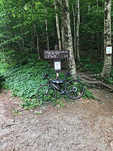
Parking:  You can park in Warren, just a quarter-mile from climb start at the public parking lot - Map
Gear:  Bring proper gearing or you'll be walking on this one - 😓.

ProvisionsWarren Store, near climb start. 
Before heading out on any cycling adventure check out our Things to Bring on a Cycling Trip and use our interactive check list to ensure you don't forget anything.
There are several climbs in the area - see the Routes in Area Tool.  There are a few quaint places to stay in the area.  If your cycling plans have you staying for a longer visit, there are many great condo and villa rentals in this popular ski area. 

ROUTE MAP

MEMBER RATING

Difficulty: Extreme
3.5
Road
5
Traffic
4
Scenery

CURRENT WEATHER

PJAMM TRIPS ADVENTURE STARTER BUNDLES

Check out PJAMM Adventure's prepackaged (self-guided) cycling trips. They will help you plan, document and conquer your next adventure.
ALL TRIPS
Browse all of our prepackaged trips and find your next adventure!
Northeast Fall Colors
United States (MA,ME,NH,NY,VT)
24 ROUTES
37 POIs
ROUTE STATS (TOTAL)
98
mi
DISTANCE
35,116
ft
ELEV. GAIN

NEARBY CLIMBS (0) RADIAL PROXIMITY

FROM
No Climbs Found

MEMBER REVIEWS & COMMENTS

Let us know what you thought of this climb. Signup for our FREE membership to write a review or post a comment.
Already have an account?

Aug 30, 2022
difficulty: Extreme
scenery: 4
traffic: 5
road: 3
Aug 30, 2022
scenery: 4
traffic: 5
road: 3
This climb is no joke due to the gradient and length. I’ve completed three Vermont Gran Fondos and I’ve never seen so many cyclists walk a climb until this one. Every cyclist should try doing this one.
Mar 20, 2021
difficulty: Extreme
scenery: 4
traffic: 5
road: 4
Mar 20, 2021
scenery: 4
traffic: 5
road: 4
Steeeeeep is right and not until the end of the climb of course🤣
ROUTE MAP
PROFILE TOOL
Route Data
S.G. (%)
hide
Segment Data
hide

Climb Profile Not Found
CLIMB SUMMARY

Cycling Lincoln Gap East - Garmin device showing 26% grade, lush tree-lined road with dense canopy and road sign for winding road next two miles, bike propped up against tree overlooking pastureland, bike with PJAMM cycling jersey draped across it propped up on trail sign for Lincoln Gap

Cycling Lincoln Gap East

Ride 4.1 miles gaining 1,453’ at 6.7% average grade.

Climb summary by PJAMM’s John Johnson.

This is a peaceful climb on a rural gap road in Green Mountains of northeastern Vermont.  The climb begins near the small and quaint town of Warren (pop. 1,705) and is just south of Sugarbush Ski Resort.

Cycling Lincoln Gap East - photo collage, Warren Village visitor's informational sign, bike propped against wooden wall of covered bridge with red building in background amidst greenery, small white gazebo with patriotic decoration, front of wooden covered bridge with American flag hanging from it, white two story building with The Warren Store sign, bike propped against deck of The Warren Store

Warren, VT is a quarter mile north of the climb start.

Cycling Lincoln Gap East - light yellow colonial era two story building with "Town of Warren, Vermont 1789" circular placard, bike leaning against front porch of building

Public parking at the Warren Municipal Building.

While this climb has peaceful and lush green surroundings, the last mile is brutally steep (¼ mile at 18% average grade and a full mile at 15.5%).  There is a flat/descent segment to the climb for 1.6 miles beginning at mile one that averages 1%, and the remainder of the climb (first and last segments) average 10%.

Cycling Lincoln Gap East - photo collage, old wooden covered bridge crossing small river, Covered Bridge Road sign in foreground with bike leaning against it, draped with PJAMM cycling jersey, multiple road signs along road surrounded with dense forestation

Top photo:  Covered bridge on the ride from Warren to the start of our climb.

Cycling Lincoln Gap East - photo collage, red wooden building with four white-trimmed windows, bike leaning against building, Danger Sharp Curves yellow road sign along greenery on roadway, bike parked in dense, tall grass with pink flowers

Section of the climb before the 15.5% final mile.

About a mile of the road is gravel, but easily manageable on a road bike.

Cycling Lincoln Gap East - dense tree canopy along two lane road, bike propped against road sign noting winding road for next two miles

The calm before the 15.5% storm. 😓

Cycling Lincoln Gap East - photo collage, bike propped against Lincoln Gap trail sign, dense tree canopy along two lane road, curve in road with steep grade road sign, yellow flowers in grass along road, bike laying down across double yellow line along a straightaway in the roadway

Lincoln Gap is the highest paved road in Vermont.

Photos are of the area within 100 yards of and at the gap.

VERMONT GRAN FONDO

“Each year the course’s four gaps are drawn from a selection of seven gaps; Appalachian Gap, Lincoln Gap, Roxbury Gap, Moretown Gap, Rochester Gap, Middlebury Gap, and Brandon Gap. The popular 6-gap ride includes all but Moretown Gap. Depending on road construction projects, which have been many, the course will vary from year to year creating a unique ride  each time.

The 2021 Gran course will again push the limits with 11K+ feet of climbing over 130+ miles and 4 mountain gaps. The course will included a double ascent of Middlebury Gap (climbing both sides), once over Brandon Gap and of course, the pinnacle climb, Lincoln Gap. The course begins in the village of Bristol, Vermont, and heads east towards Lincoln. Climbing, albeit light to begin with, starts just 1.5 miles in. You’ll climb up towards the center of Lincoln and then on towards Ripton and the first mountain climb, Middlebury Gap. From Middlebury Gap, you’ll desend into Hancock and then climb out of the valley heading north towards Warren and the turn to Lincoln Gap; this is where the real challenge begins.

With a 24% maximum grade and an average grade of 15%, the east side of Lincoln Gap is reported to be the steepest paved mile in the U.S., according to Bicycling Magazine (June 2008) and now one of the world’s steepest climbs by Global Cycling Network (GCN).”  VTGF

Stats

Distance – ~130 miles (209 km)

Max Elevation – 2,556 ft

Max Grade – 24%

11,700 ft (3566 m) of climbing

Gravel surface – ~24-34** mi

Climbs – 4 Gaps

Middlebury (west to east) 2,123 ft

Lincoln (east to west) 2,415 ft

Brandon Gap (west to east)

Middlebury Gap (east to west) 2,123 ft

Access to full Climb Summary requires a PJAMM Cycling PRO Membership!

It takes less than a minute to sign up & with your PRO membership you can:
  • Rate climbs, post comments and share your experiences on any of our climb pages
  • Create bucket lists of climbs & mark the dates you complete them
  • Weather data for all climbs - Start & Finish
  • Upload photos to your member page to customize your PJAMM Cycling experience
  • Utilize all of our interactive tools - Profile & Routes in Area
  • Download climb route .gpx files
LEARN MORE
SIGN UP

Already have an account? LOG IN HERE