
19.7
PDI
8 mi
DISTANCE
3,045 ft
GAINED
6.9 %
AVG. GRADE
FULL CLIMB STATS
INTRO
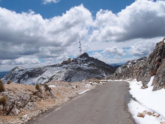
Sierra de la Pandera from Valdepeñas de Jaén is a 12.9 km (8.0 mi) climb that gains 928 m (3,045 ft) at a 6.9% average grade, from 906 m (2,972 ft) to 1,792 m (5,879 ft). It starts roughly 300 m higher than the longer approach from Los Villares, so it is shorter and punchier, and it finishes on the same summit road below the military installations on the ridge.
The climb is a pair of efforts. The first 7 km (4.3 mi) are moderate, averaging 6.2% through Mediterranean forest, but from km 8 to km 10 (5.0-6.2 mi) the road averages 11.6%. The steepest kilometer reaches 13.0%, the steepest 500 m 13.2%, and then the road eases to 7.2% before flattening to 1.5% over the last 0.9 km (0.6 mi). The slopes become more arid as you gain altitude, with lavender, thyme, rosemary and gorse along the verge.
This is the approach the Vuelta a España has used. The Pandera has hosted stage finishes since 2002, and on stage 14 of the 2026 race the peloton descended the Puerto de Locubín and passed through Valdepeñas de Jaén on its way to the foot of the climb. On a clear day the summit looks out toward the Sierra Nevada, with the olive groves of the Sierra Sur spread beneath you.
PLAN YOUR ROUTE
 We've partnered with Sherpa-Map.com to bring you the best route planning tool. With a PRO Membership you can use this climb as a reference when creating your route.
Sierra de la Pandera from Valdepeñas de Jaén averages 6.9% over 12.9 km (8.0 mi), gaining 928 m (3,045 ft), but the average hides a savage middle.
Km 0-3 (0-1.9 mi): 6.4% through forest, with a gentle first kilometer.
Km 3-7 (1.9-4.3 mi): 6.1%, with a brief breather around km 4-5 before the road kicks up again.
Km 7-8 (4.3-5.0 mi): 6.3% as the road tilts up toward the hard part.
Km 8-10 (5.0-6.2 mi): 11.6% - the heart of the climb.
Km 10-12 (6.2-7.5 mi): 7.2% on the upper slopes.
Km 12-12.9 (7.5-8.0 mi): 1.5% to the finish.
Km 3-7 (1.9-4.3 mi): 6.1%, with a brief breather around km 4-5 before the road kicks up again.
Km 7-8 (4.3-5.0 mi): 6.3% as the road tilts up toward the hard part.
Km 8-10 (5.0-6.2 mi): 11.6% - the heart of the climb.
Km 10-12 (6.2-7.5 mi): 7.2% on the upper slopes.
Km 12-12.9 (7.5-8.0 mi): 1.5% to the finish.
The steepest 500 m averages 13.2%, the steepest kilometer (0.6 mi) 13.0%, the steepest 2 km (1.2 mi) 12.0%, the steepest 5 km (3.1 mi) 9.0% and the steepest 10 km (6.2 mi) 7.8%. The single steepest 100 yards (91 m) reaches 13.9%.
Roadway: The road is paved the entire way. The A-6050 is wide and in good condition, but the summit road was built to serve the military installations on the ridge, and it is narrower and rougher as it climbs. Jaén's tourism board notes the first major ramps begin near a quarry, where gradients reach about 15%, and that motor-vehicle access to the summit road is restricted by a key system. The very highest point on the ridge has been reported fenced off.
Traffic: Light on the A-6050 around Valdepeñas de Jaén and minimal on the summit road, where vehicle access is restricted. You may meet quarry trucks near the lower ramps.
Parking: Valdepeñas de Jaén is a small town of about 3,500 people at roughly 920 m, so street parking near the edge of town puts you on the A-6050 within minutes. Riders based in Jaén city face a transfer of about 31 km (19.3 mi) to the start.
Gear: The middle of the climb averages 11.6%, so a compact crank with a 32-tooth or larger rear cog is strongly advisable. The upper slopes are exposed, and wind can be a factor near the ridge.
Provisions: Carry at least two full bottles. There is no shelter on the upper mountain, and Andalusian summer heat can be severe - spring and autumn are the smart seasons to ride. Refill in Valdepeñas de Jaén before you start.
Before heading out on any cycling adventure check out our Things to Bring on a Cycling Trip and use our interactive check list to ensure you don't forget anything.
Valdepeñas de Jaén was founded in 1539 as part of the repopulation of Jaén's mountain areas, and its Renaissance Church of Santiago Apóstol anchors the main square. Nearby, the restored Santa Ana mill houses an ethnographic museum, and the single-arch Santa Ana bridge over the Ranera river is probably medieval. For a post-ride walk, the Quebrajano reservoir and the Las Chorreras water spots are close, and the town is also known for the centuries-old Quejigo del Carbón oak. Dishes to look for include lamb (carnerete), migas with potatoes and roscos de vino. The Cristo de Chircales pilgrimage on the first Sunday of May and the Realenga festival in mid-August are the big dates.
The Los Villares approach to this same summit is covered on our Sierra de la Pandera (Los Villares) page, and the Vuelta stage descends the Puerto de Locubín on the way here. See what else is within reach with our Routes in the Area tool.
ROUTE MAP

MEMBER RATING
CURRENT WEATHER
PJAMM TRIPS ADVENTURE STARTER BUNDLES
Check out PJAMM Adventure's prepackaged (self-guided) cycling trips. They will help you plan, document and conquer your next adventure.
NEARBY CLIMBS (0) RADIAL PROXIMITY
FROM No Climbs Found
MEMBER REVIEWS & COMMENTS
Let us know what you thought of this climb. Signup for our FREE membership to write a review or post a comment.
Already have an account?
LOG IN HERE
