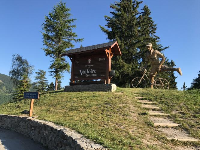
![Cycling Col du Télégraphe Cycling Col du Télégraphe - wooden chalet style sign reading Valloire]()
Cycling Col du Télégraphe
Ride 11.7 kilometers gaining 829 meters at 7.1% average grade.
We have documented the Col du Telegraphe PLUS route (Telegraphe + Galibier), but the true Col du Telegraphe climb is 11.7 km beginning in Saint-Martin-de-Maurienne. Most cyclists use the Col du Télégraphe as a link to Col du Galibier, one of the most famous bike climbs in the world.
![Cycling Col du Télégraphe Cycling Col du Télégraphe - photo collage shows street signs along the climb]()
Climb begins in Saint-Michel-De-Maurienne which just south of the epic cycling center of Saint Jeanne de Maurienne.
.
![Cycling Col du Télégraphe Cycling Col du Télégraphe - photo collage shows pastoral country scenes on first few KM of climb.]()
First few kilometers of the climb.
![Cycling Col du Télégraphe Cycling Col du Télégraphe - PJAMM Cyclist rides on side of roadway and takes selfie showing two tour busses passing him]()
Since this is the primary route to the popular ski resort town of Valloire, there can be a fair amount of traffic (and buses!) depending on the time of year and day you climb.
![Cycling Col du Télégraphe Cycling Col du Télégraphe - photo colage shows Valloire KM marker signs on side of roadway]()
Col du Télégraphe got its name from the television and radio towers near the summit.
![Cycling Col du Télégraphe Cycling Col du Télégraphe - photo collage shows street signs along the climb, one-lane roadway surrounded by greenery]()
The gradient is steady throughout and the steepest kilometer only 8.5%.
We are surrounded by forest much of the climb, which blocks the wind and makes for a calm and peaceful climb. This is a contrast to Col du Galibier - the next climb on this route - which is above tree line most of the climb.
![Cycling Col du Télégraphe Cycling Col du Télégraphe - photo collage shows beautiful French Pyrenees mountain views along the climb, Maurienne Valley]()
There are some wonderful views of the Maurienne Valley as we climb.
![Cycling Col du Télégraphe Cycling Col du Télégraphe - photo collage of kilometer markers along the route]()
Kilometer monuments keep us informed of what’s ahead as we climb.
![Cycling Col du Télégraphe Cycling Col du Télégraphe - photo collage shows kilometer markers along the route]()
![Cycling Col du Télégraphe Cycling Col du Télégraphe - photo collage, climb finish, Fort du Telegraphe, street signs]()
Have a meal or snack at Fort du Télégraphe at the finish.
Google Reviews.
CYCLING COL DU TÉLÉGRAPHE AND COL DU GALIBIER
![Cycling Col du Télégraphe Cycling Col du Télégraphe - photo collage, cyclists climb on two-lane roadway toward snow dotted mountain tops, PJAMM Cyclist stands with bike in front of green mountain views, road sign for Galibier]()
From Col du Télégraphe descend 4.8 kilometers at -3.5% (188m) to the ski resort of Valloire, and from there experience one of the greatest cycling experiences in France and the world - Col du Galibier. The BIG climb (Telegraphe + Galibier South) elevates Telegraphe to one of the most challenging climb segments in France and ranks it high in the Top 200 World Climbs at 35.2 km (20.7 mi), 2,115 m (6,648’) ascent at 5.4% average grade (7.1% climb only - removing the Col du Telegraphe to Valloire descent).
![Cycling Col du Télégraphe Cycling Col du Télégraphe - photo collage, signs for Galibier, KM marker, large statue of elk]()
![Cycling Col du Télégraphe Cycling Col du Télégraphe - photo collage shows green mountain views on the Galibier climb]()
![Cycling Col du Télégraphe Cycling Col du Télégraphe - PJAMM Cyclist John Johnson poses with bike at mountaintop finish for Col du Galibier]()
COL DU TÉLÉGRAPHE APPEARANCES IN THE TOUR DE FRANCE
The Tour has made Col du Télégraphe a famous climb in France and the world, first appearing in the Tour in 1911, along with Col du Galibier (the highest point in any tour for a long time to come). Riders of the TdF have ridden up or down this climb twenty times between 1947 and 202. The 2022 tour will mark it’s twenty-first appearance. Télégraphe is never a mountaintop finish and always a link to the mighty Col du Galibier.

 We've partnered with Sherpa-Map.com to bring you the best route planning tool. With a PRO Membership you can use this climb as a reference when creating your route.

