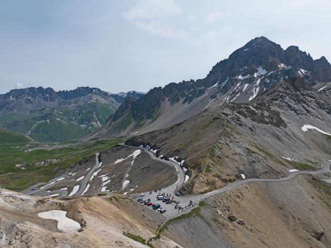
![Cycling Col du Galibier from Valloire: panoramic view of roadway snaking up snow-dotted alps]()
Cycling Col du Galibier from Valloire
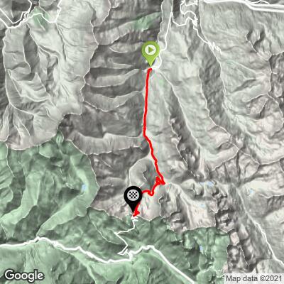
Ride 17.4 kilometers gaining 1,199 meters at 6.9% average grade.
Col du Galibier is located in the French Alps and is the fourth highest paved pass in Europe, after Col de l'Iseran (2,764 meters), the Col Agnel (2,744 meters), and the Col de la Bonette (2,715 meters).

Cycling Col du Galibier, one of the world’s most scenic cycling climbs.
World Top 10 Most Scenic Bike Climb.
This one is one of the world’s great cycling climbs. Col du Galibier is located in one of the great climbing areas of the world and is a must if you’re in or near France’s southeastern Auvergne-Rhone-Alpes Region or Savoie Department. Of course, a five to seven day climbing trip to Saint-Jean-de-Maurienne is an experience of a lifetime and would definitely include this exceptional Col. The pass is named after Le Grand Galibier, which towers over the Col and is the highest mountain in the Massif des Cerces of the French Alps (3.228 meters). The route from Valloire is the most popular route up Col de Galibier.

Climb begins in the ski resort of Valloire.
Valloire is a commune in the Savoie Department, Auvergne-Rhône-Alpes region.
Population 1,132 (2014), elevation 735 m.
![Cycling Col du Galibier from Valloire: photos along the first third of the climb include mountain views, road conditions, and yellow and white kilometer markers]()
Photos along the first third of the climb.

This is one of three common routes to Col du Galibier:
- From Valloire (most popular: climbed by 53,445 Strava members as of January 25, 2020);
- From Villar-D’arene (11,154 Strava members); and
- From Briancon (5,511 Strava members).
![Cycling Col du Galibier from Valloire: photo collage shows road conditions, street signs, and greenery and mountain views on middle third of the climb; roadway spray painted with "TDF"]()
Photos along the middle of the climb.
![Cycling Col du Galibier from Valloire: photo collage shows aerial drone and panoramic views of hairpin turns at kilometer 10]()
There is a two kilometer set with six hairpins at 8.5% beginning at kilometer 10.

This sign is on Col du Télégraphe on the way to Valloire and the beginning of the Galibier climb.
Col du Galibier is part of the Route des Grandes Alpes, a tourist itinerary that begins in Thonon-les-Bains and travels over many of the most spectacular passes in France and Europe, including Col de L’Iseran, Galibier, d’Izoard, and Bonette; (alternate route includes Croix de Fer and Madeleine). The route connects Lake Geneva to the Mediterranean Sea.

Route des Grandes Alpes.

Livestock aplenty on the climb.

La Ferme du Galibier
Kilometer 13 of Col du Galibier from Valloire.

Stunning scenery the entire route.
There are no permanent residents on the mountains after passing the village of Bonnenuit at kilometer 5 at 1670 meters.
![Cycling Col du Galibier from Valloire: photo collage shows green hillsides, cobble bridge over small stream, and patches of snow along the final third of the climb]()
Photos along the final third of the climb.

Stay left at the fork (photo top right).
Tunnel (no) to the right, Col du Galibier (yes) to the left.
![Cycling Col du Galibier from Valloire: photo collage shows final set of hairpin turns before climb finish, with Col du Galibier and vehicle tunnel pointed out]()
Final set of hairpins before the summit.
![Cycling Col du Galibier from Valloire: photo collage shows final hairpins at climb finish, patches of snow lining the roadway]()
Seven hairpins for 1.3 kilometers at 9.3% near the top, then 400 meters straight at 10.6% to the finish.
![Cycling Col du Galibier from Valloire: aerial drone view shows final 50 meters of climb, roadside painted with colorful blocks, remnants of Tour de France]()
You will be reminded of the Tour de France in many spots along the climb . . .
. . . not the least of which will be the final 50 meters.
KILOMETER MARKERS

There are markers nearly every kilometer of the climb.


The steepest kilometer is the last, averaging 10.5%.
![Cycling Col du Galibier from Valloire: photo collage shows road signs, kilometer marker signs, and views at climb's finish]()
Col du Galibier
![Cycling Col du Galibier from Valloire: photo collage shows lookout point and vista views just passed climb finish]()
Hike about 50 meters up the mountain from the Col parking lot for spectacular views.
COL DU GALIBIER TOUR DE FRANCE HISTORY
TOP 10 MOST FREQUENT CLIMBS OF THE TOUR DE FRANCE
AND 10 FAMOUS ONES AFTER THAT
As of 2022 Col d’Galibier has been featured 64 times in the TdF
More TdFs than all but four other climbs.
© PJAMMCycing.com
© Climb name | Elevation (meters) | Times highest point of TdF (as of 2022) | Mountain Range | Times Featured in Tour de France | Most recent | First included |
Cime de la Bonette | 2,802m | 4 | Alps | 4 | 2008 | 1962 |
Col de l'Iseran | 2,770m | 8 | Alps | 8 | 2019 | 1938 |
Col Agnel | 2,744m | 1 | Alps | 2 | 2011 | 2008 |
Col du Galibier | 2,642m | 50 | Alps | 63 | 2022 | 1911 |
Col du Granon | 2,413m | 0 | Alps | 2 | 2022 | 1986 |
Top Five high points of the Tour de France
Col du Galibier has also been the highest point in a TdF 50 times.
Also see Top 10 Highest Points of the TdF.
Included in the Tour 63 times from 1911 through 2022, Galibier was passed as the highest point in the Tour each year from 1911-1914 (suspended 1915-1918 WWI) and 1919-1937. In all, Col du Galibier has been the highest point in any individual TdF significantly more times than any other climb (50 times; Col de L’Iseran is second with only eight).

Bartali handing Coppi a water bottle on the Galibier in the 1952 TdF,
Or Coppi sending it back to Bartali -- the debate rages . . .
Photo: iconicphotos.com
Haute Route quotes Henri Desgrange in his praise of this climb:
The Galibier became a legend at the very first time it was used by the Tour de France, in 1911. This is how Henri Desgrange, creator of the Tour de France, introduced it to his readers: “Oh! Sappey! Oh! Laffrey! Oh! Col Bayard! Oh! Tourmalet! I will not fail in my duty in proclaiming that next to the Galibier you are as weak as dishwater: before this giant there’s nothing one can do but doff one’s hat and bow down low,” (translation by Marvin Faure; Hauteroute.org - Col du Galibier).
When first crossed in 1911 by the Tour de France, no tour rider had ever ridden higher. Although until 1976 the Galibier route took the tunnel at 2,556 meters, since 1976, the Tour has gone over the pass at the top which is 2,642 meters.

Andy Schleck, Stage 18 of the 2011 Tour de France.
Col du Galibier -- highest mountain top finish ever.
Photo: roadbikereview.com
As with many of the challenging and beautiful climbs of France, Galibier is fabulously famous because it has been justifiably blessed by the Tour de France on many occasions (35 times since its first post WWII appearance in 1947, which was the first TdF since 1940). Most recently (as of 2020) Galibier was featured in The Tour in 2019 (Nairo Quintana won the stage from Embrun to Valloire). In 2017 debutante Primoz Roglic became the first Slovenian to win a TdF stage when he came out on top in Stage 17 from La Mure to Serre-Chevalier.

Primoz Roglic, Stage 17 Tour de France.
First Slovenian to win a TdF stage.
Photo: Cyclingtips.com
Of Galibier and the Tour de France, Wikipedia writes:
The Col du Galibier was first used in the Tour de France in 1911; the first rider over the summit was Emile Georget, who, with Paul Duboc and Gustave Garrigou were the only riders not to walk.
![Cycling Col du Galibier from Valloire: bike parked against base of large stone memorial for Henri Desgrange, first director of Tour de France]()

Emile Georget, Col du Galibier, 1911
Photo: Emile Georget.
The original summit was at 2556 m; while the tunnel was closed from 1976 until 2002, the tour route went only over the pass closer to the mountain peak at 2645 m. In 2011, the Tour de France went through the tunnel for the first time during the 19th stage from Modane Valfréjus to L'Alpe d'Huez.
At the south portal of the tunnel, at the edge of the road, there is a monument to Henri Desgrange, instigator and first director of the Tour de France. The memorial was inaugurated when the tour passed on 19 July 1949. Whenever the tour crosses the Col du Galibier, a wreath is laid on the memorial. The "Souvenir Henri Desgrange" is awarded to the first rider across the summit of the highest mountain in each year's tour. In 2006, the prize of 5,000 euros was claimed on the Col du Galibier by Michael Rasmussen.
Since 1947, the Col de Galibier has been crossed 31 times by the Tour de France. It was scheduled to be used in 1996, but was left out at the last minute due to bad weather. As a result of snow on both the Col de l'Iseran and the Col du Galibier, the scheduled 190 km stage from Val-d'Isère to Sestriere in Italy was reduced to a 46 km sprint from Le-Monetier-les-Bains which was claimed by Bjarne Riis, resulting in him taking the yellow jersey which he retained to the finish in Paris.
In the 2008 Tour, the Col du Galibier had been crossed on 23 July in the 210 km stage 17 from Embrun to Alpe d'Huez.
The 2011 Tour climbed the Col du Galibier twice to celebrate the 100th anniversary of the first appearance of the pass in the Tour de France, including the first ever summit finish, won by Andy Schleck after a 60 km solo breakaway. This was the highest ever stage finish in the Tour de France. It was scheduled to be used again in stage 20 of the 2015 Tour, but was left out nine days before the race start due to landslides in the Chambon Tunnel, situated towards the bottom of the descent of the climb.”
The Telegraphe, and Galibier, are the scene of the greatest racing day in the life of Marco Pantani. It was here and in this Stage 15 of the 1998 TdF that Pantini attacked on the Galibier and ultimately turned a three minute deficit into an 11 minute lead against Jan Ullrich. Pantini went on to win the Tour de France that year.

Pantani attacks 4.2 km from Galibier summit.
Photo: Cycling-passion.com