![]()
You will not find a more distinctive mountain anywhere in the world than Mt. Fuji.
Climb summary by PJAMM’s John Johnson.
![]()
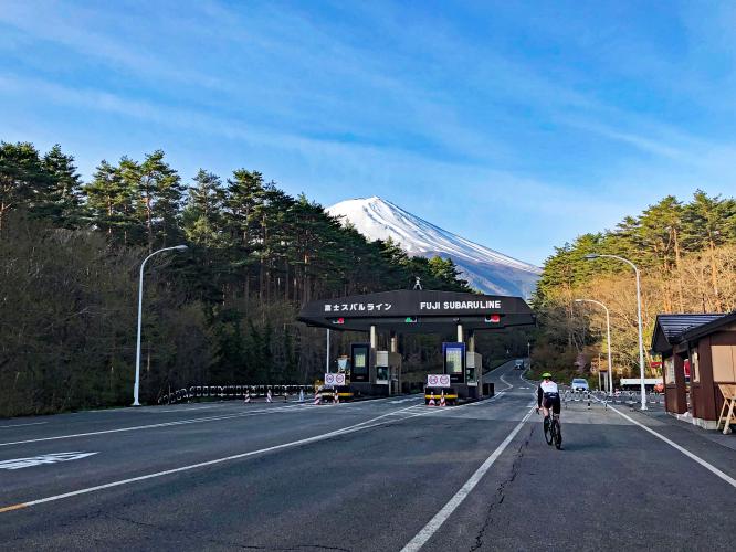
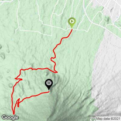
Cycling Mt. Fuji’s Subaru Line to Subaru 5th Station.
25.4 kilometers (15.8 miles) 2,281m (7,485’) gaining 1,279m (4,195’) at 5%.
Summit of Mt. Fuji: 3,776 m (12,388’).
![]()
![]()
Mt. Fuji as seen from the International Space Station.
CYCLING MT. FUJI TO SUBARU 5TH STATION
Mt. Fuji’s Subaru Line is by far the most popular of the four 5th Lines. A 5th line is the end of the road and start of the hiking routes to the summit of Mt. Fuji. This approach is also the most scenic and busiest of the 5th Line approaches.
![]()
Near the start of the climb.
There are more views of Mt. Fuji on the Subaru Line bike climb than any other approach.
The climb up Subaru Line itself is fairly mild, with a steady 5% grade for the most part throughout. If you have the opportunity to ride just one approach to a Mt. Fuji 5th Station, we recommend this one. The steepest kilometer is only 7.4% (Azami Line 15.4%; Gotemba 12.9%; Fujinomiya 12.4%) and you are never seriously challenged – at least not the way you are on the Azami, Gotemba or Fujinomiya Lines.
![]()
Breathtaking views on this route.
Subaru Toll Road as of May 2019 is 2000 yen ($18 USD).
![]()
Japanese Alps in the background.
![]()
Station 4, kilometer 18.5.
![]()
![]()
Subaru Station 5th Line -- year-round, weather permitting.
The Subaru Line is also the venue of the largest bicycle race in Japan, and perhaps all of Asia. Each year in early June, about 8,500 cyclists participate in the Mount Fuji Hill Climb. Note that our guide, Tim Smith, advises that the weather is often cold and rainy at this time of the year on Mt. Fuji.
![]()
Start of Mt. Fuji Hill Climb
Photo: Brompton Wharton
THE BEST LAID PLANS . . .
Our Mt. Fuji cycling experience was complicated by one major oversight which, in the end, turned out to be an unqualified blessing in disguise – PJAMM good fortune if you will.
We travelled to Japan for the sole purpose of climbing Mt. Fuji by bike and this extraordinary volcano did not disappoint. The rides were exceptional, but the adventure getting there was as much the story as the climbs themselves.
![]()
PJAMM’s May 2019 Asian Trip Itinerary.
We flew direct from San Francisco International to Tokyo’s Narita International (not the best choice we later learned). Our troubles at Narita date back to my misfortune in Paris during our European cycling trip the summer before. My camera gear, passport and other miscellaneous possessions were stolen in Paris at the end of our trip. I had replaced most of what had been stolen, but made one major oversight that would define our Mt. Fuji trip from the beginning.
Our flight was smooth and landed on time. We breezed through immigration and then customs at Narita. Our luggage and bikes were waiting for us at baggage claim – our bikes were actually delivered directly to us by Narita baggage handlers – that was pretty cool.
We had rented a van and had our mini Sea Sucker roof racks with us so we could transport the bikes on top of the car, freeing up valuable space inside the car for our steamer trunk-like luggage pieces that necessarily accompany us on these multi-country trips.
And then . . . PJAMM began its own version of:
![]()
The trip hit the skids at the Hertz counter when the clerk asked a question that sent a chill down my spine: “May I see your international driver’s license.” Eeek – What International Driver’s License!? That question refreshed my shaky recollection that my IDL had been stolen in Paris – and, what’s worse is that I had not remembered to replace it. Learning that at the Hertz window in Tokyo is really bad timing . . .
![]()
Plan C
Planes, trains, buses and automobiles . . .
Travel Tip #1: You must have an international driver’s license to operate (and rent) a vehicle in Japan.
We had no plan B.
Attempt at Plan B #1: What about Uber – nope - 50,000¥ ($456 USD). Taxi? No - 52,776¥ ($480 USD). It was 197 kilometers to Kawaguchiko, where we were staying for our two days and four climbs of Mt. Fuji.
The problem we would have without a vehicle is that our Colombian photographer and drone operator extraordinaire, Javier, would not be able to accompany us up the mountain without a vehicle – this eliminated the otherwise good option of just using the train and bus to get to the start of each climb with our bikes.
![]()
Javier on drone duty . . .
Another complication that was out of our control was that our photographer/videographer/droneographer Javier’s flight from Colombia had been re-routed to Haneda International Airport, about 1½ hours from Narita International where we were. We had planned on picking Javier up on our way to Kawaguchiko, but that plan went in the trash bin along with the rental car reservation. Javier hopped a bus to Kawaguchiko where we would (much later) meet up with him.
Attempt at Plan B #2: I had two contacts in Japan that I had met online while researching cycling Mt. Fuji. I had planned on meeting both at Mt. Fuji for some of our climbs. I emailed Caleb and Jerry and they both set to working on alternative transportation for us. The first decision we made was to take the train from Narita to Shinjuku Station, the bus from Shinjuku Station to Kawaguchiko Bus Station, and finally a taxi from the bus station to our hotel two kilometers from the bus station.
Enroute to Kawaguchiko we were contacted by Tim Smith of Astuto Cycling Center (tims@gsastuto.com) who I had communicated with before traveling to Japan. Tim had been quite responsive and knowledgeable about Mt. Fuji in advance of our trip, but we had originally intended to self-guide our rides up Mt. Fuji, as is PJAMM’s custom. To our good fortune Tim was available and willing to guide us for our two days on Mt. Fuji. Tim is a custom builder of high-end cycling wheels who also oversees cycling tours throughout Japan.
Tim picked us up from our hotel at 5 a.m. on Saturday to begin our four Fuji climbs in two days. The next two days were pure joy – not only does Tim know every inch of Mt. Fuji from each of the four approaches to the 5th Stations, but, having cycled extensively in Europe and Asia, he is also an expert at cycling in general, cycling in Japan, nutrition, and coaching and training (he is a UCI cycling coach).
![]()
Tim in Full Support Mode!
![]()
Astuto support crew.
We learned that there is a gorgeous Five Lake Bike Loop in and around Mt. Fuji. There are also many excellent and beautiful climbs in the Japanese Alps not far from Mt. Fuji. Tim’s company has a residence in the Japanese Alps and offers tours of Mt. Fuji, the lake loop, the Japanese Alps and more.
![]()
Mitch with the Japanese Alps in the background.
Station 4, kilometer 18.5.
Tim is originally from the US and speaks English and conversational Japanese, having lived and worked in Japan for 10 years. As with all PJAMM endorsements, they are purely to assist our readers in experiencing climbs throughout the world, and are made only in relation to products and services that we sincerely believe in and appreciate – we receive absolutely no financial benefit from our endorsements. With that qualification, we unequivocally and wholeheartedly recommend using Tim Smith and Astuto for any cycling trip you are interested in that is anywhere near Tokyo, Mt. Fuji and/or the Japanese Alps. Tim’s business has “ongoing cycling excursions and rentals available almost year round” for anyone wishing to climb or ride Fuji. Find out more on Astuto’s website here.
HIKING FROM 5TH STATION TO MT. FUJI SUMMIT
Big-time adventurer Kyle Stanton-Wyman of Bremerton, WA writes for the hike up to Mt. Fuji (as part of our bike-hike sometime in the future):
In regards to a Fuji summer summit - yes I have done that once and it is much more achievable. I climbed the Gotemba route in August of '18 during the official climbing season. Strava link for details and photos.
Fuji (when snow free) is a 'simple' hike and doesn't require any technical climbing skills or equipment, but it is still a very strenuous hike. Gotemba is the longest of the four routes at 7,400 vft, and the other three are around 4,000 vft. Beware that you might suffer from the high altitude, given the summit is at 12,388 ft. It is most popular to start the hike pre-dawn, and summit in time for sunrise as that is typically when the weather is clearest. Given the peak's isolated nature, it is often obscured in clouds by the afternoon. Also be warned that the three shorter trails are EXTREMELY busy during the official climbing season, especially on weekends (check out the picture of the traffic jam of hikers on my strava link). During the official climbing season there are also open noodle huts selling food and water on the summit. Outside the official climbing season, the summit may still be relatively snow free and easy to hike, especially in early fall, and there will be far fewer people, but no services.
Lastly, here are the three rules for off season climbing.
Although the website says it's "prohibited", that's a mis-translation. They just want to make sure you are fully prepared for the conditions.
I'm sure you got the road riding beta from Caleb. Based upon that, I think a bike and hike is perfectly possible on any of the 4 routes!
As the most popular tourist site in Japan, more than 200,000 people climb to the summit of Mt. Fuji each year. There are “huts” along the route to cater to climbers (National Geographic). Our awesome guide Tim explains that there are “now many guide services, bus excursions and suppliers for hiking Fuji...the classic method is to leave late at night, then spend a few hours in one of the mountain shacks, then trek to the summit for sunrise. Fuji is stunning anytime of the day or night -- so you could just climb it anytime. But make sure you can descend in the daylight.” As “the land of the rising sun,” it makes sense that many hikers prefer to see the sunrise from Fuji’s summit. The sunrise upon Mt. Fuji even has a special name, Goraiko (National Geographic). Tim also reminds us to stay safe and come prepared when hiking on Fuji, as “weather on the mountain changes rapidly...you can be in snow, hail, rain, or completely clear skies all within a day. So always pack a light rain jacket and/or gloves for chilly descents, and for sure remember some sunblock.”
This website is excellent and tells you all you need to know about hiking to the top of Mt. Fuji.
SOME HISTORY OF THE MOUNTAIN
According to Encyclopedia Britannica’s entry on Mt. Fuji, this near-symmetrical mountain is the highest point in Japan, rising to 12,388 feet (3,776 metres) near the Pacific Ocean’s coast in central Honshu, about 60 miles (100 km) west of the Tokyo-Yokohama metropolitan area. Mt. Fuji is still generally classified as an active volcano by geologists, though it has been dormant since its last eruption in 1707. Additionally, Mt. Fuji is the major feature of Fuji-Hakone-Izu National Park (1936), and it is at the centre of a UNESCO World Heritage site designated in 2013.
The meaning of Mt. Fuji’s name is actually highly debated. Here are some theories: In the 10th century text The Tale of the Bamboo Cutter, Mt. Fuji’s name is said to come from the word “immortal” and the idea of soldiers ascending the mountain’s slopes (ancient samurai used the base of Mt. Fuji as a training area), other tales claim that Fuji’s name means “never ending,” while still others posit it means “without an equal” or “peerless one.” Even British missionary Bob Chiggleson chimed in at some point to suggest that the name comes from the Ainu word for “fire.” So many different definitions exist, but “perhaps Mount Fuji means all of the above. In Japan’s long and winding history, this mountain has always stood there strong, holding different meanings for anyone who ever stood in awe under its shadow” (The Meaning Behind the Name). Because of the location of the mountain (within what was the main route of travel in Japan in the 1600s), many people throughout history have had the opportunity to witness Fuji in all its splendor, meaning that it has been a focal point in many historical texts and artworks throughout the years. It’s said that in 663 a monk was the first to ascend the mountain, and that the first ascent by a foreigner was by Sir Rutherford Alcock in 1868 (The History Behind the Mountain).
There is also a strong spiritual element to Mt. Fuji, as it is one of Japan’s sacred mountains. Since at least the 7th century, Fuji has been a sacred site for practitioners of Shinto, the indigenous faith of Japan. Shinto shrines can be found all along the base and ascent of Mt. Fuji, honoring the Shinto supernatural deities, called kami. With a whole series of shrines (the Segan shrines) dedicated to her, Mt. Fuji’s kami is the Princess Konohanasakuya, whose symbol is the cherry blossom (National Geographic). The Smithsonian has an awesome article about Mt. Fuji’s enduring power as a spiritual force in Japan. You can read the full text here. The article explains that for followers of Shinto, “Kami wield power over various aspects of life and can be mollified or offended by the practice or omission of certain ritual acts. ‘The notion of sacrality, or kami, in the Japanese tradition recognizes the ambiguous power of Mount Fuji to both destroy and to create,’ says H. Byron Earhart, a prominent American scholar of Japanese religion and author of Mount Fuji: Icon of Japan. ‘Its power can demolish the surrounding landscape and kill nearby residents. But its life-giving water provides the source of fertility and rice.’”