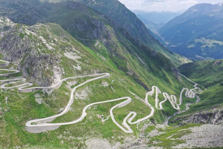
![Cycling St. Gotthard Pass, Switzerland: panoramic view looking down on mountainside, with hairpins snaking their way up the climb route]()
Cycling Gotthard Pass (St. Gotthard Pass), Switzerland.
The world’s greatest Hairpin-Cobble combination in the world.
World Top 10 Epic Bike Climb
Climb summary by PJAMM’s John Johnson.
This route over the “old road” traverses the Saint-Gotthard Massif and has connected northern and southern Switzerland since medieval times. The southern route from Airolo is the most epic and famous because it passes over four kilometers of time honored cobbles. As of 2023, the pass has been included in the Tour de Suisse 40 times, most recently Stage 7 in 2019.
, Switzerland")
Gotthard Pass is, and has been historically, a very important roadway. It is one of the two main connecting roads through the Swiss Alps, between northern and southern Switzerland (the other, in the west, is Lötschberg). Before the 13th century, this pass was not frequently used, since traveling the area would require fording the turbulent Reuss river, which was often swelling with snowmelt coming down the mountains. After the first wooden bridge crossing the area was built in 1220, Gotthard Pass gained prominence as an important traversing point through the Swiss Alps. Because of Gotthard’s importance in transit throughout the country and beyond, the area became the hub of the Swiss Confederacy in the early 14th century.
The name “Gotthard Pass” has been commonly used to describe the area as far back as 1236, shortly after the southern slope of the mountain was consecrated by the archbishop of Milan (in 1230). The name comes from Saint Gotthard of Hildesheim, the patron saint of mountain passes. You can read more about the history of the area here.
, Switzerland")
Tour de Suisse Stage 7 finished at Gotthard Pass in 2019
Image: Cycling Stage
“At 2108m above sea level, the Gotthard Pass may not be the highest Alpine pass in the Tour de Suisse, but no other pass has been crossed as often in the 81-year history of the TdS – a total of 40 times [as of 2023], closely followed by the Lukmanier Pass, which has featured in the tour programme 34 times,” (Tour de Suisse).
It’s all about the road and the experience -- the road itself is a visual marvel.
, Switzerland")
![Cycling St. Gotthard Pass, Switzerland - photo collage shows bike laying on roadway at the end of the pavement and beginning of the cobblestones; bike leans against kilometer marker sign, marking km 122]()
Get ready to RUMBLE!
Cobbles begin at kilometer 7.1; from here it is 5.4 km to the top at 7.2%.
![Cycling St. Gotthard Pass, Switzerland - photo collage shows PJAMM Cyclist riding on cobblestone roadway, traversing switchbacks]()
It’s the 1-2 punch of amazing hairpins and ancient cobbles that make this one of the most remarkable cycling experiences in the world -- and worthy of most bucket lists. While the climb is not challenging by Top World Climb standards, we were sure not to miss it on our 2017 Top World European Climb Trip, even going a bit out of our way to ride it.
![Cycling St. Gotthard Pass, Switzerland - photo collage shows PJAMM cyclist riding on hairpin turn on cobbled roadway, aerial drone view of three huge hairpin turns in cobbled road]()
![Cycling St. Gotthard Pass, Switzerland - photo collage showcases panoramic and aerial drone views of Gotthard Pass' famous hairpin turns]()
Gotthard’s hairpins rival Stelvio, Alpe d'Huez, and Lacets de Montvernier.
![Cycling St. Gotthard Pass, Switzerland - aerial drone view shows iconic hairpin turns snaking up entire mountainside]()
, Switzerland")
We begin our climb in Airolo (population 1,500 as of 2016), in the state (canton) of Ticino, and province of Leventina in south-central Switzerland, near the relatively close tip of the Italian border. If you couldn’t tell based on the location and names of the area, the language spoken in this part of Switzerland is Italian.
, Switzerland")
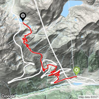
There are a couple of forks in the road that can cause slight confusion, so it is best to have a GPS map loaded or a hard copy map or directions with you if you are new to the climb and don’t have anyone familiar with Gotthard Pass with you. There is an initial set of 12 switchbacks between miles 1-4, but the famous set are further up the old road, with 24 switchbacks during a 2.2 mile 6.9% segment (through miles 4.9 to 7.1).
The climb itself is 7.8 miles, gaining 2,870’, at 7.15% average grade. The steepest quarter-mile is 8.4%, half-mile is 3.2%, one mile is 8%, and 2.5 miles is 7.4%. In other words, it is a consistent grade throughout.
, Switzerland")
The hairpins and cobbles make this a world class bucket list climb; the cobbles are well maintained.
We are also treated to rangeland cattle and a couple waterfalls along this fairly brief climb.
, Switzerland")
, Switzerland")
Gotthard Pass is included in the Grand Tour of Switzerland, a famous motor vehicle route that takes in many of the amazing and scenic views of Switzerland.
, Switzerland")
Grand Tour of Switzerland
1600 kilometers, 22 lakes, five alpine passes, and twelve UNESCO World Heritage sites.
In addition to Gotthard Pass, the Grand Tour includes Furka Pass, Sustenpass, and Grimselpass in this area.
, Switzerland")
![Cycling St. Gotthard Pass, Switzerland - PJAMM cyclist rides on cobbles at climb's finish]()
Finish.
At the top of the climb is a lake, Lago della Piazza, along with a couple nice cafès.
, Switzerland")
, Switzerland")
Finish at Lago della Piazza.
We took the smoother route back to the bottom via the highway (Route 2), but one of our group was very distressed at the finish as he is not a fan of fast descents on major highways. There was minimal traffic, but one could consider that route marginally safe. Thus, for those averse to highway riding, consider returning down the cobbles -- bumpy but certainly safe -- bring padded gloves.
, Switzerland")
Highway N2, the alternate route back to the start.
Includes a long tunnel, so bring lights.
Note: PJAMM Cyclist Helmuth Dekkers recommends against riding much on N2 -- see below.
Further climb summary by our friend and PJAMM contributor Helmuth Dekkers (NL).
From Airolo there are in three roads to Hospental. The first is the A2 motorway that uses the Gotthard Tunnel. The other two roads go via the Gotthardpass. There is a new and an old road. The new road, the N2, is not an option as it's the preferred route for the traffic and hence too busy for cyclists. Add to it that it runs through two tunnels of 300m and 1600m long. Need I say more? And when you know the picture of the old road via the Val Tremolo (the shaking valley) from Mountain Higher (the book from Daniel Friebe & Pete Goding) then there is only one choice! Up to the Gotthardpass via Val Tremola, the old cobble road. Did you say cobbled?
Yes I did. And it's not the whole ascent that is cobbled, but the only the second half (5.5km out of the 12.9km) and the cobbles (or maybe “setts” is a better word, but I'll hang on to cobbles if by cobbles we mean granite cubes) are not like the big cobbles that are found on the ascents of the Tour of Flanders or Paris-Roubaix. I did it on my road bike but have to admit I have 28mm tires. But I am sure that any road bike will be fine to be used as these cobbles are a lot smaller and much better laid out too.
Anyway, I arrived in Airolo coming down from Nufenenpass and followed the Via dell Stazione until I noticed a sign indicating to turn left to the Passo San Gottardo. This small road takes you to the N2. Yes, at the start you will need to follow the N2 road for a bit. Fortunately cyclists can turn right after 1.3km on the N2 (or 1.7km after the turn off as described above which is considered as the foot of the ascent) to take the old road and leave the N2 behind. After 1.7km from the foot you'll pass below the N2. And after 2.5km cars from the N2 can join from a road coming from the right.
After 4.1km we pass the N2 again but now it runs below you. At 5.4km you again get the chance to go to the N2. And again we ignore it and follow the old road. To the right you can see the N2 higher up running through a rockfall protection gallery. At 6.9km we again pass below the N2. The N2 can be seen from many points and after you reached the cobbled second half of the ascent you'll see the N2 high up to the left of you running through a rockfall gallery.
The Val Tremola valley has opened up by now and soon after the cobbles have begin you'll also encounter numerous cobbled hairpin turns that twist and turn to take you higher up in the valley. I loved this part. The hairpins are so beautifully constructed with rough stonework on the outside to support them. And then the repeating pattern of the cobbles is mesmerizing. It's not a fan pattern that is used but repeating, stacked arc patterns. Doesn't matter, I like the repeating arcs.
Here and there, there are red cobbles used to indicate the center of the road. You'll also see regularly an indication how far it is to the Hospiz which is located next to the Lago della Piazza (lake) at the pass. After many hairpins, the last 1km to the top lacks hairpin turns and has only one 90 degree left hand turn in it. Then you cycle the last part up between two buildings and see the Eagle sculpture, next to the Lago della Piazza. The sculpture is not there for the pass but to commemorate the downed military pilot Adrien Guex who crashed here in 1927 with his Fokker D VII biplane during a reconnaissance flight due to poor visibility.
So, you reached the Gotthardpass (2108m). In case you enjoyed this road, I recommend you cycle a little bit back down on the N2 to get to a viewpoint where you can see the old 'Val Tremola' road in all its glory. In fact, you can take your own 'Mountain High' picture from that point. When you stand in front of the Eagle sculpture, turn left and then turn left again to get on the N2. This part of the N2 has a decent shoulder where you can cycle on until you are close to where the rockfall gallery starts. To the left you'll see the beautiful road you just cycled sneaking its way up through the Val Tremola with the numerous hairpins.
, Switzerland")
The PERFECT vantage of the greatest hairpins in Switzerland (and the world?).
, Switzerland")
Arrow to viewpoint for best hairpin photos.
Ride down about 400 meters from the pass to just before the tunnel.
What a view! Then turn back to cycle to the pass. You can take the yellow Postbus here to get back to Airolo if you don't want to descend via the cobbles, or on to Hospental on the other side of the Gotthardpass in case you want to avoid the traffic. When I was there at the end of September on a weekday I just took the N2 down to Hospental and that was fine. Not much traffic and it was not dangerous at all. But, look at the traffic when you are there and decide for yourself. You can install the SBB app on your smartphone to find out the time the bus leaves from the pass.
, Switzerland")
Thank you Helmuth!!